


Albanchez de Mágina – Cima del Aznaitín
A direct ascent from Albanchez de Mágina to one of the most iconic peaks of the Sierra Mágina. A short but demanding climb over varied terrain, combining traces of mountain life with a panoramic finish offering sweeping views.
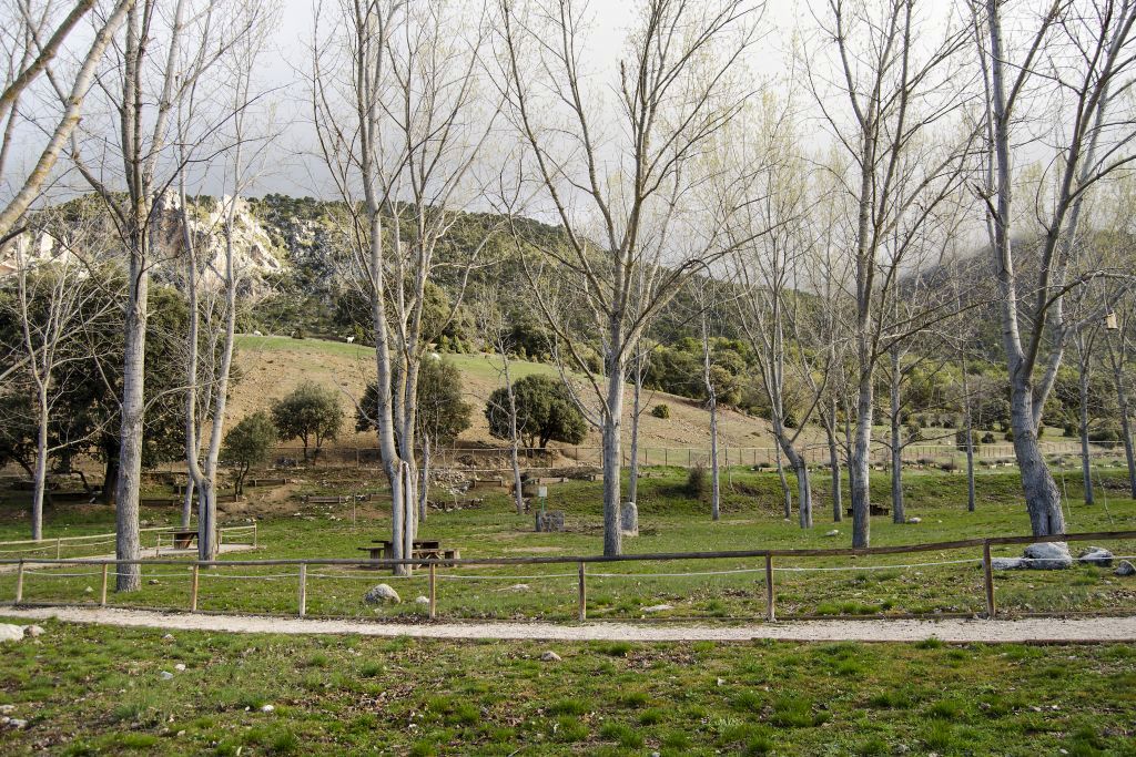
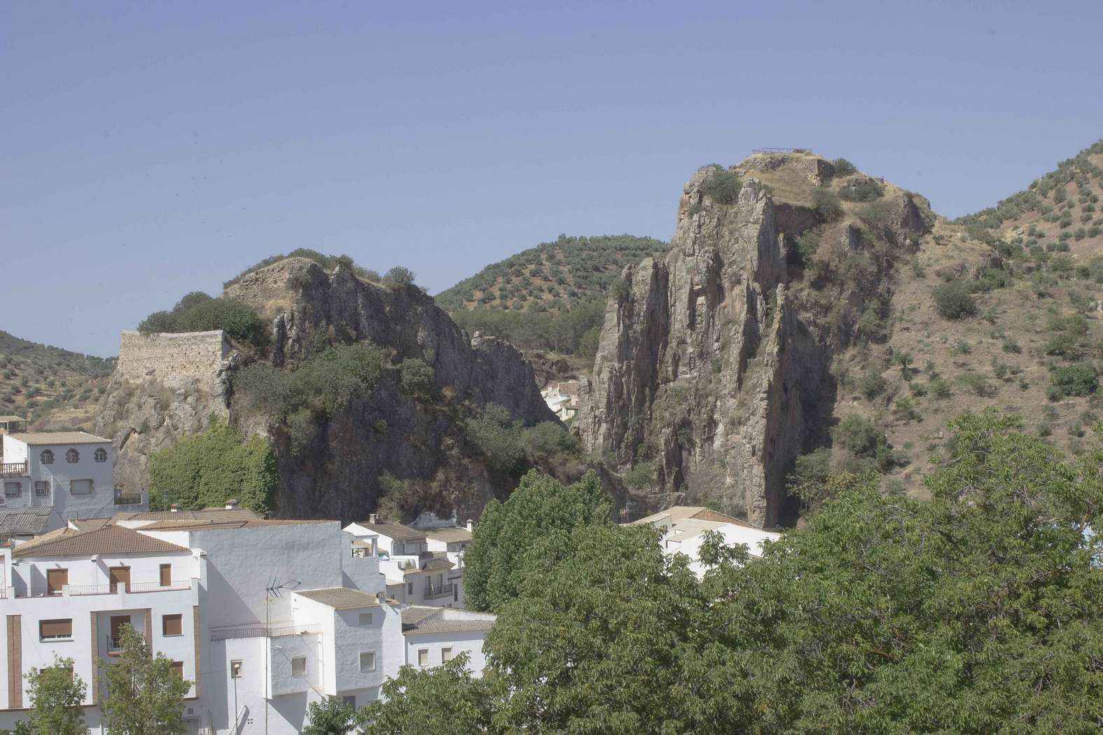
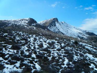
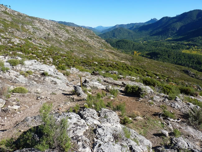
The route offers a direct ascent from Albanchez de Mágina to the summit of Aznaitín (1,745 m), following an initial stretch of asphalt, then a forest road, and finally a rocky trail. The route begins next to the Town Hall and gains elevation along Calle Horno, passing whitewashed houses until reaching the edge of the village and facing the north-northeast slope of the mountain range.
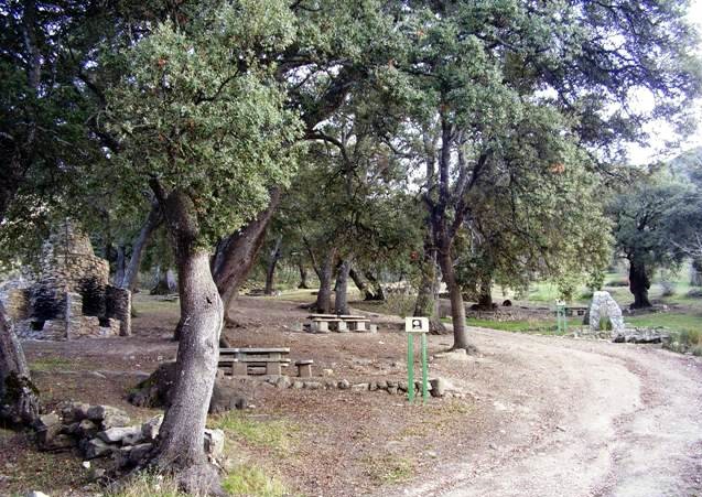
As you ascend, the landscape becomes more austere and distinctly mountainous. The slope is steady, and the elevation gain is concentrated over just a few kilometers, so it’s best to maintain a steady pace. In the middle section, the first signs of traditional high-altitude life appear: the remains of a snow pit, used for storing and transporting ice between the XVIII and XIX centuries, and the ruins of a shepherd’s hut, simple dry-stone structures associated with shepherding and the use of the mountains.
The final stretch leaves the trail to follow a well-defined path that climbs steeply through scree and limestone, until it reaches the summit of Aznaitín, a true natural balcony. From here, the views open up in every direction: the heart of the Sierra Mágina, the region of La Loma and the Guadalquivir Valley, the dark silhouette of the Sierra Morena, the mountain ranges of Cazorla and Las Villas, and the peaks of the Sierra Sur. A panoramic viewpoint that rewards the effort of the climb.
The route ends at the summit, returning along the same path.
General Recommendations
This route is recommended for hikers in good physical condition. Check the weather forecast before setting out, wear hiking boots with good traction, and we recommend using trekking poles on steep and rocky sections. Bring plenty of water and avoid hiking in extreme heat or strong winds.
Rutómetro
Galería de fotos


Explora cerca de este punto
Descubre otros lugares cercanos en el mismo municipio.
Valdepeñas de Jaén – Noalejo – Campillo de Arenas (C1)
Descripción corta para el card
Albanchez de Mágina
Albánchez de Mágina
Turismo activo
Participación Activa
Paisaje
Flora
Fauna
Geología
Tradiciones
Patrimonio
Bedmar y Garcíez
Oficina de Turismo de Huelma
Noalejo
Bélmez de la Moraleda
Cabra del Santo Cristo
Cambil
Campillo de Arenas
Cueva de la Graja – Los Caracoles – Pinar de Cánava (R1)
Albanchez de Mágina – Cima del Aznaitín
Columpio Gigante de Torres – Barranco del Arroyuelo – Portillo de la Zarzadilla
Área Recreativa Fuenmayor – Albanchez de Mágina
Jaén – Puente de la Sierra – Otíñar – Carchelejo – La Guardia (C2)
Fuenmayor, Navaparis, altos de Mágina (C3)
Cambil – Mata Bejid – Huelma –Arbuniel (C4)
Torres – Mata Bejid – AR Río Cuadros –Bedmar – Pinar de Cánava – Puerto de Trisla (C5)
Bélmez de la Moraleda – Cabra de Santo Cristo -Solera (C6)
Cabra del Santo Cristo · Estación de Huesa · Alicún de Ortega · Estación de Cabra del Santo Cristo (C7)
Bedmar – Jódar – Paraje Natural Alto Guadalquivir - Úbeda – Baeza (C8)
Área Recreativa El Peralejo – Área Recreativa Fuenmayor
Área Recreativa El Peralejo – Pico Mágina - Miramundos (R6)
Barranco del Gargantón
Área Recreativa Río Cuadros – Caño del Aguadero
Piedra del Palo

Mirador del Pico Almadén
Mirador de la Alberquilla
Centro de vuelo de Pegalajar - 7 Pilillas
Cárcheles
Huelma
Jimena
Jódar
Pegalajar
Larva
Torres
Mancha Real
La Guardia de Jaén
Antiguo Ayuntamiento de Larva
FUENTE DE LA SEDA
Agua e historia se entrelazan en un manantial que recuerda la antigua prosperidad sedera del municipio.
Ermita,Santuario de cuadros - Bedmar
Castillo de Albanchez de Mágina
Refugio de Miramundos
Paraje de Hútar
Barranco y Área Recreativa El Peralejo
Área recreativa la Peñuela
Área Recreativa de Gibralberca
Área recreativa La Cañada
Paraje y manantial de Fuenmayor - Área recreativa
Oficina de Turismo de Cambil y Arbuniel
Oficina de Turismo de Cabra del Santo Cristo
Oficina de Turismo de Noalejo
Centro de Visitantes Mata Bejid
Centro Interpretación del Aceite de Sierra Mágina D.O.P
Centro de Interpretación "La Leyenda y la Frontera"
Museo de Historia Local de Jódar
Centro de Interpretación Pioneros de la Fotografía - Casa Arturo Cerdá y Rico
Centro de Interpretación “El Pajarillo”
Aula de la naturaleza
Refugio del Cerro de Enmedio
Oleoturismo
Gastronomía
Ecoturismo
Castillo Viejo de Bedmar
Castillo Nuevo de Bedmar
Castillo de Bélmez
Castillejo del Cortijo de Neblín
Castillejo del Barranco de Aguas Amarguillas
Castillejo del Cerro de San Juan
Castillo de Cambil
Castillo de Alhabar o Al Habar
Castillo de Mata Bejid
Castillo de Arenas
Castillo de Solera (s.XIII)
Castillo-Fortaleza de Alburquerque (s.XVI)
Castillo de Jimena
Castillo de Jódar
Castillo de La Guardia de Jaén
Castillo de Ríez
Zonas de escalada de Pegalajar
(1. En bloque: Perdigón, El Ático, Escondite; 2. Deportiva: Arabaico, Aromático, Iniciación; 3. Clásica: Portichuelo, Peña de los Buitres, Peña Grajera)
Vía Ferrata Al Manzur en la Serrezuela de Bedmar
Vía ferrata Cambil
Museo del Agua en el lavadero del Chopo
Conexión con Larva (C9)
Sectores de Escalada Deportiva en Torres
Zona de Escalada de Jódar
Cerro Golondrina
Zona de Escalada de Bedmar / La Serrezuela
Castillo de la Guardia
Piedra del Palo – Embalse del Quiebrajano
Peña del Castillo de Cambil
Sector Santa Lucía
Zona de Escalada de Cueva Palomera
Despegue de la Peña del Águila
Despegue del Almadén
Cultural
Etnografía
Arte rupestre
Paraje del Caño del Aguadero
Torre del Reloj
Fuente de los siete caños
Casacada Caldera del Tío Lobo
Iglesia Parroquial de Santo Domingo
Palacio de los marqueses de Camarasa o de los Cobos
La Puente
Columpio Gigante de Torres
Cueva del Morrón
Cimbras y Pasarelas colgantes
Sendero “Muro Alto”
Torre del Reloj
Iglesia Parroquial de Nuestra Señora de la Asunción
Castillos Viejo y Nuevo
Centro de Interpretación Paleomágina
Via Ferrata Al-Manzur
Palacio de los Marqueses de Viana de Garcíez
Ermita de Nuestra Señora de Cuadros
Mirador del Torreón de Cuadros
Sociedad Cooperativa Andaluza Bedmarense Magnasur
Consejo Regulador Denominación de Origen Sierra Mágina
Adelfar del río Cuadros
Cascada del Zurreón
Centro de Interpretación de las Caras de Bélmez
La casa de las caras de María Gómez
La Torre del Lucero
Fuente del Gargantón
Cuevas del Chato y Baltibañas
Barranco del Arroyo Gargantón
Iglesia Nuestra Señora de la Expectación
Centro de Interpretación Casa Arturo Cerdá y Rico
Casa de la misericordia
Paraje del Nacimiento
La encina milenaria - Cabra del Santo Cristo
El Cerro de Cabeza Montosa
Puente sobre el arroyo Salado
Puente de tierra
Iglesia de Nuestra Señora de la Encarnación
Ruinas del Castillo de Arenas
Ermita de Santa Lucía y Paraje de Puerta de Arenas
Ermita y Museo de la Patrona Santísima Virgen de la Cabeza
Centro de Interpretación “La Leyenda y la Frontera”
La Casa forestal de Prados Bajos
Sierra de Campillo : Barranco del Monasterio, Mirador de La Alberquilla, El Paraje de la Piedra del Palo
Iglesia de Santiago el Mayor
La Cueva de la Graja
Paraje de Cánava
La Ermita de Nuestra Señora de los Remedios
El Pilar y la Albarrada de la fuente del Moro
La Cruz de la Atalaya
Los caracoles
Pinar de Cánava
Iglesia de la Asunción
Centro de Interpretación “Xodar” de la historia del castillo
Colección museográfica “La artesanía del esparto en la historia de Jódar”
Huerto de la Cora
Iglesia Nuestra Señora de los Ángeles
Iglesia de San Juan Evangelista de Mancha Real
Antiguo Convento de los Carmelitas Descalzos
Mirador El Morrón
Mirador de Peña del Águila
Pico Mojón Blanco
Sistema hidráulico: Fuente de la Reja - La Charca – Huertas
La Serrezuela de Pegalajar
Área Recreativa “Siete Pilillas”
La Cueva de los Majuelos
Arco de la Encarnación
Iglesia de la Santa Cruz
Ayuntamiento de Pegalajar
Centro de interpretación de la Caminería de La Cerradura
Lavadero Municipal de Pegalajar
Iglesia de Nuestra Señora de los Remedios
Convento de Cazalla
Iglesia Parroquial de San Pedro Apóstol
Antiguo Ayuntamiento de Larva
El Cerro de Castellón
Museo de Artes y Costumbres Tradicionales de Larva
Pilar–Lavadero de Larva
Área recreativa “La Cañada”
Castillo de La Guardia de Jaén
Iglesia de Nuestra Señora de la Asunción
Lavadero público de la Segunda República y Museo
Conjunto Monumental Plaza Isabel II
Necrópolis Visigoda de Cerrillo Salido
Cueva Cabrera
Ruinas de Castellón de Cazalla
Iglesia Santuario del Santo Cristo de la Misericordia
Ermita de San Marcos
Fuente de Carchalejo
Paraje Cazalla
Cueva del Puerto de las Palomas
Los Llanos de Palomares
Iglesia de Nuestra Señora de la Asunción
Ayuntamiento de Noalejo
Ermita de la Virgen de Belén
Réplicas de las sábanas Santas de Turín
Ruta del Santo Custodio
Centro de Interpretación de La Santería
Ermita de la Virgen de la Cabeza en Hoya del Salobral
Paraje de Navalcán
Casa de la Fundadora Doña Mencía de Salcedo
Iglesia de la Inmaculada Concepción
El Museo del Agua
Ermita de Nuestra Señora de la Fuensanta
Casco urbano de Huelma
Pico Mágina y Miramundos
Ermita de San Sebastián y Fuente del Santo
La fuente de Carchelejo
Descubre nuestra pasión, paso a paso
ExpoHuelma: Feria de Muestras del Parque Natural Sierra Mágina
Procesión del Rosario de Los Hachones
Fiestas Patronales en honor del Santo Cristo de Cabra
Las Fiestas de Moros y Cristianos de Bélmez de la Moraleda
Recreación de “Batalla de 1823”
La fiesta de “Moros y Cristianos”
Castillo de Cambil y Alhabar
Iglesia Parroquial de Nuestra Señora de la Asunción
Casa Palacio
Antiguo Hospital de Pobres Pasajeros
Casa de los Salazares
Nacimiento del río Arbuniel
Iglesia Parroquial San Juan Bautista de Arbuniel
Las Fiestas y tradiciones de Huelma
Conjunto histórico
Castillo de las Peñuelas
Ayuntamiento de Pegalajar
El Festival de Arte flamenco
Puente sobre el Arroyo “Salao”
Paraje de “El Pozuelo”
Mirador Campos de Larva
Feria de San Marcos
Fiestas Patronales de la Virgen de Belén
Fiesta de la Floración del cerezo
Fallas de San José
Moniduras
Conjunto Monumental Plaza Isabel II
Follow us #JaénParaísoInterior


