


This municipality is part of:
La Iruela
La Iruela is a small, pretty village in the north-east of the Sierra de Cazorla region. The western part of the town is made up of farmland, while the rest of the municipality is a mountainous area reforested with pine forests. It belongs to the Parque Natural de las Sierras de Cazorla y Las Villas, being its main gateway.
The municipality of La Iruela, as if it were a jigsaw puzzle, is made up of numerous nuclei, 17 districts that make up the municipality. Burunchel, El Palomar, El Burrueco, Arroyo Frío, Fontanares, La Estrella, Mortalejos, Tramaya, El Pocico, San Martín, Pasada Barrero, Los Tíscares, Arroyos de Plaza, Juntas de Muriel, Nubla, Don Roque and Cañamares.
The municipality's economic activity is based on two basic pillars: olive growing and nature tourism, with forestry activity also standing out.
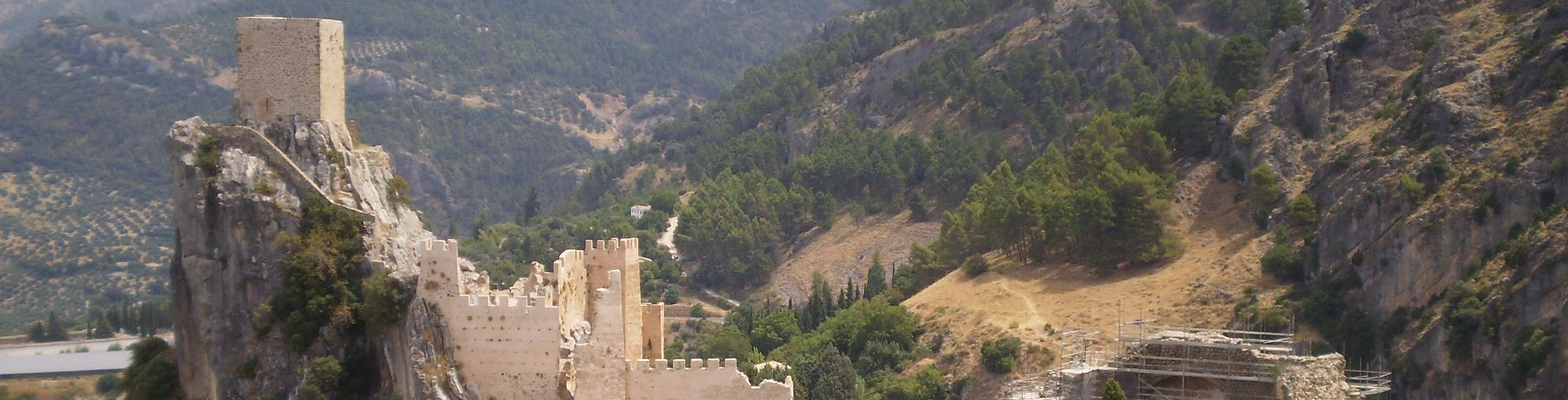
Its historical heritage includes the Medieval Castle, the ruins of the Church of Santo Domingo de Silos and the Town Hall.
La Iruela was declared a Historic-Artistic Site in 1985.
Information
Culture
- Castle of La Iruela. The imposing castle stands on a steep crag and at its feet is a medieval quarter of unquestionable architectural value. It is of Almohad origin and is built on pre-Berber foundations. In the 8th century, La Iruela was occupied by the Muslims and in order to cultivate the land they created farmhouses, later walls to defend themselves from enemies, and in the 12th century, the first of the three fortress enclosures that it has today. The second, also built by the Almohads, was a parade ground surrounded by a series of defensive towers linked together by thick walls. Inside the parade ground are the remains of a large cistern. When Ferdinand III conquered this area, the Christians reformed the castle and built the keep on the highest part of the crag. It was the headquarters of the Order of the Knights Templar. Nowadays, an auditorium has been created between the castle and the rock, where artistic and cultural activities are held. It was declared a Historic Monument in 1985.
- Ruins of the Church of Santo Domingo. Renaissance church from the 16th century, built inside the walled enclosure of the castle. The church consisted of three naves, the central nave being the widest and where the presbytery was located, while the side naves housed chapels. A building annexed to the churc ...
Culture
- Castle of La Iruela. The imposing castle stands on a steep crag and at its feet is a medieval quarter of unquestionable architectural value. It is of Almohad origin and is built on pre-Berber foundations. In the 8th century, La Iruela was occupied by the Muslims and in order to cultivate the land they created farmhouses, later walls to defend themselves from enemies, and in the 12th century, the first of the three fortress enclosures that it has today. The second, also built by the Almohads, was a parade ground surrounded by a series of defensive towers linked together by thick walls. Inside the parade ground are the remains of a large cistern. When Ferdinand III conquered this area, the Christians reformed the castle and built the keep on the highest part of the crag. It was the headquarters of the Order of the Knights Templar. Nowadays, an auditorium has been created between the castle and the rock, where artistic and cultural activities are held. It was declared a Historic Monument in 1985.
- Ruins of the Church of Santo Domingo. Renaissance church from the 16th century, built inside the walled enclosure of the castle. The church consisted of three naves, the central nave being the widest and where the presbytery was located, while the side naves housed chapels. A building annexed to the church was the old tower-door of Muslim origin that gave access to the interior of the Almohad fortress and which the Christians reused as a bell tower. During the French invasion, La Iruela suffered attacks and fires, one of which in 1810 left the building badly damaged. Today some of its noble areas are still standing.
- Town Hall. This is a Mudejar-style monument in the Toledan style that was once a granary and grain store. It dates from the end of the 15th century. It was sacked and burnt down during the War of Independence. In the mid-19th century it was used as the Town Hall of La Iruela. A remodelling carried out at the end of the last century gave it its current appearance.
Nature
La Iruela is located in the foothills of the Sierra de Cazorla mountain range, crowning the Guadalquivir valley. It is situated at 932 m. above sea level, which makes it the highest municipality in the whole region, and the one with the largest portion of the Sierras de Cazorla, Segura y Las Villas Natural Park.
If anything characterises the area it is the variety of landscapes and ecosystems, with altitudes ranging from 2,100 m. in the Sierra de La Cabrilla to 360 m. in the vicinity of the Puente de La Cerrada.
The region is characterised by landscapes where high peaks mingle with deep ravines, gentle reliefs and wide valleys, forests, olive groves and high mountain pastures, orchards, wet, dry and arid areas. The altitude rises from west to east, but not continuously, but in the form of mountain ranges, whose slopes rise and fall with progressively steeper gradients, alternating between river courses and ridgelines.
The traditional uses made by the inhabitants of these lands have been pasture for livestock, forestry, small areas of traditional crops (olive groves, cereals, vegetable gardens), hunting, fishing, mushroom and wild fruit gathering, and a variety of popular handicrafts, mainly esparto grass and wickerwork.
These traditional uses have given way to new economic activities, mainly service businesses, especially tourism, in the area of the Natural Park. Today La Iruela has a large tourist infrastructure which, together with those of the cities of Úbeda and Baeza, are the most important in the province of Jaén.
Nowadays the olive groves have been displacing the rest of the crops, the hills are occupied by a sea of olive trees interrupted, sometimes, by orchards, all framed by the surrounding mountain ranges. In the driest and most arid areas, almond trees splash the spring with white.
A space with a multitude of ecosystems in which an infinite number of species make up its rich and varied fauna: from birds of prey, carrion eaters, game species, both large and small game, fish, amphibians, reptiles, as well as the characteristic birdlife of the riverside vegetation along the banks of streams and rivers.
Undoubtedly, a true natural paradise for recreation. It is almost obligatory to establish direct contact with some of the marvellous spots hidden in this territory, where, in addition to observing the vegetation and fauna in situ, we can enjoy fabulous panoramic views of the mountains and the countryside of Jaén.
Most of the land in La Iruela belongs to the Monte Público Guadahornillos, with just over 6,740 hectares.
In the municipality of La Iruela the following public facilities are of note:
- Aula de la Naturaleza "El Cantalar".
- Tejerina" Recreational Area.
- Viewpoint "Paso del Aire".
- Borosa River Path (partial)
- Path from Arroyo Frío to Cerrada de Utrero (partial)
- Viewpoint "Ribera del Guadalquivir", located on the path from Arroyo Frío to Cerrada de Utrero.
- Various sections of the GR-247 Bosques del Sur. Stage 10 "Refugio CF La Zarza - La Iruela" and branch stage "Puerto de las Palomas-Arroyo Frio".
- Most of the GR-7 "Coto Rios to Vadillo Castril" and some sections of the Vadillo Castril - Quesada section.
Fiestas and Events
We begin the festive season in La Iruela in January::
- San Antón, on the 17th of January. It is a tradition to light bonfires and bless the animals so that San Antonio Abad protects them throughout the year
- San Blas, on 3 February. The traditional doughnuts are handed out and a raffle is held with the products donated by the villagers. A few days before the celebration of the fiesta, the image is brought from its hermitage in Nubla. During the procession, the saint is the subject of many offerings in gratitude for the favours received.
- Festivities in honour of the Virgen de los Desamparados and Santo Domingo de Silos. These are held in the last days of August. There are many and varied activities: fireworks, barter championships, mountain bowling, domino tournaments, local produce and gastronomy competitions, children's theatre, parades, recitals and open-air dances. The Virgin is brought from her hermitage in La Heredad to the parish church, where she will remain until autumn, when she will return again.
- San Martín and the Virgen del Rosario. This pilgrimage has been held on the first weekend in October since time immemorial. In the hamlet of San Martín
- Festivity in honour of the Assumption of the Virgin Mary. It is celebrated between the 13th and 15th of August and takes place in the districts of Arroyo Frío and El Palmar.
- Festivities in honour of the Immaculate Conception and San Julián. From 22nd to 25th August. It is held in the hamlet of Burunchel. The saint is taken from the hermitage of San Julián to Burunchel, where he is carried in procession.
Gastronomy
It shares its gastronomy with that of the mountainous region where it is located. In general, the stews are made with local products. Among the most characteristic are the following:
- Gachamiga, which is made with olive oil, flour, water and potatoes. It can be eaten with chorizos, torreznos (bacon)...
- Gachas de harina con caldo (flour porridge with broth), which is made with hard dough.
- Tagliatelle. It consists of a meat, vegetable and mushroom stew in which wafers of dough are baked and left in pieces.
- Rin-Ran. With red pepper meat, onion, potatoes, cod, black olives and olive oil.
- Serranos eggs. Usually served in a casserole with pork products such as chorizo, streaky bacon and game meat.
- Other: At Easter, dishes made with cod and fried artichokes are traditional.
Confectionery:
Pastries:
- Fleurs de lis. They are made with a very liquid mass of flour and fried in a pan in a hot iron mould.
- Leche frita (fried milk) and Roscos de azúcar (sugar donuts).
History
The first signs of human presence in the area around La Iruela date back to the Copper Age, with heavy occupation until the Bronze Age. After that there was a depopulation of the area for which researchers have no explanation, since over time we witnessed a proliferation of settlements. One of these is Nubla, with the remains of a fortification, which was active from the Iberians until the Middle Ages, as was also the case in Roman times, and the Molino bridge that crosses the river Cañamares is attributed to this period.
It has been said that the Carthaginians founded the town, that it was populous in Roman times and that the Arabs destroyed it and then populated and rebuilt it.
During the Islamic period it must have been one of the farmhouses that populated the region. Around the 11th century this town was walled and the top of the promontory served as a refuge.
In the time of King Ferdinand III and thanks to the troops of the Archbishop of Toledo, the castle and the rest of the municipality were conquered. In gratitude, the king gave him the jurisdiction of these lands within the Adelantamiento de Cazorla. At the end of the 13th century, in order to reinforce the alfoz of Cazorla, La Iruela was donated as a hamlet, but La Iruela did not want to accept this privilege given to Cazorla.
On some occasions it was granted the privilege of Villa, but only for very short periods of time.
Francisco de los Cobos, secretary to Carlos I, managed to get the monarch to cede the town to him to the detriment of the Archbishop of Toledo, who fought until 1606, when he regained it again. During this short period of time, the Cobos family, great patrons of the lands of their Lordship, ordered the construction of the Church of Santo Domingo de Silos inside the castle grounds.
The archbishops of Toledo always maintained possession of this town until 1811, the year in which the Cortes of Cadiz suppressed the territorial jurisdiction of the archbishopric of Toledo. Spiritual jurisdiction over these lands lasted until 1958, when it passed to Jaén.
Source of information
Ayto. La Iruela
Imágenes
Contenido Audiovisual
? ![]()
Destinations
Nature
Culture
Destinos
Culture
Nature
Culture
Discover Essential


Plan your trip
Plan your trip
An error occurred while processing the template.
Syntax error in template "20101#20127#1641310" in line 8, column 44:
Unknown built-in: "Longitud". Help (latest version): https://freemarker.apache.org/docs/ref_builtins.html; you're using FreeMarker 2.3.29.
The alphabetical list of built-ins:
abs, absoluteTemplateName, ancestors, api,
boolean, byte,
c, capFirst, capitalize, ceiling, children, chopLinebreak, chunk, contains, counter,
date, dateIfUnknown, datetime, datetimeIfUnknown, default, double, dropWhile,
endsWith, ensureEndsWith, ensureStartsWith, esc, eval, exists,
filter, first, float, floor,
groups,
hasApi, hasContent, hasNext, html,
ifExists, index, indexOf, int, interpret, isBoolean, isCollection, isCollectionEx, isDate, isDateLike, isDateOnly, isDatetime, isDirective, isEnumerable, isEvenItem, isFirst, isHash, isHashEx, isIndexable, isInfinite, isLast, isMacro, isMarkupOutput, isMethod, isNan, isNode, isNumber, isOddItem, isSequence, isString, isTime, isTransform, isUnknownDateLike, iso, isoH, isoHNZ, isoLocal, isoLocalH, isoLocalHNZ, isoLocalM, isoLocalMNZ, isoLocalMs, isoLocalMsNZ, isoLocalNZ, isoM, isoMNZ, isoMs, isoMsNZ, isoNZ, isoUtc, isoUtcFZ, isoUtcH, isoUtcHNZ, isoUtcM, isoUtcMNZ, isoUtcMs, isoUtcMsNZ, isoUtcNZ, itemCycle, itemParity, itemParityCap,
jString, join, jsString, jsonString,
keepAfter, keepAfterLast, keepBefore, keepBeforeLast, keys,
last, lastIndexOf, leftPad, length, long, lowerAbc, lowerCase,
map, markupString, matches, max, min,
namespace, new, nextSibling, noEsc, nodeName, nodeNamespace, nodeType, number, numberToDate, numberToDatetime, numberToTime,
parent, previousSibling,
removeBeginning, removeEnding, replace, reverse, rightPad, root, round, rtf,
seqContains, seqIndexOf, seqLastIndexOf, sequence, short, size, sort, sortBy, split, startsWith, string, substring, switch,
takeWhile, then, time, timeIfUnknown, trim, truncate, truncateC, truncateCM, truncateM, truncateW, truncateWM,
uncapFirst, upperAbc, upperCase, url, urlPath,
values,
webSafe, wordList,
xhtml, xml
1<#--
2Nombre: JPI - Lista contenidos para mapa
3Tipo : Evento
4<#include "/templates_SERVLET_CONTEXT_/0/global/cms/evento/lista-contenidos-para-mapa.ftl" />
5-->
6
7<script>
8console.log("Longitud: ${Longitud?exists ? Longitud.getData() : 'No existe'}");
9console.log("Latitud: ${Latitud?exists ? Latitud.getData() : 'No existe'}");
10console.log("Titulo: ${Titulo?exists ? Titulo.getData() : 'No existe'}");
11console.log("ImagenDestacada: ${ImagenDestacada?exists ? ImagenDestacada.getData() : 'No existe'}");
12</script>
13
14<#if (Longitud?exists) && (Latitud?exists) && (Longitud.getData()?? && Longitud.getData() !="" ) && (Latitud.getData()?? && Latitud.getData() !="" )>
15 <li
16 data-color=""
17 data-structure=""
18 data-longitud="${Longitud.getData()}"
19 data-latitud="${Latitud.getData()}"
20 data-title="${Titulo.getData()?default('Sin título')}"
21 data-image="${ImagenDestacada.getData()?default('')}"
22 data-url="">
23
24 <div class="img-miniatura" title="foto-evento" style="background-image:url(${ImagenDestacada.getData()})">
25 </div>
26 <span>
27 ${Titulo.getData()}
28 </span>
29 </li>
30
31 <script>
32 console.log("** Lista de contenidos para mapa datos existen");
33 </script>
34
35 <#else>
36 <script>
37 console.log("ERROR: No existe algun dato: ${Titulo.getData()} ${ImagenDestacada.getData()} ${Longitud.getData()} ${Latitud.getData()});");
38 </script>
39 </#if>


