


Complejo Arroyo de la Rambla (PB-4)
Singular places
, Peal de Becerro
Arroyo de la Rambla Complex
Discovered in 1992. Currently it reaches a total of 5,117 m of development with important prospects for exploring new galleries. This very important complex is located in the vicinity of the Pantano de la Bolera, in the Barranco known as Arroyo de la Rambla, the two access points open in the municipality of Peal de Becerro (Jaén) and a large part of the cavity develops under the term of Cazorla (Jaén). Along with this great complex, several more cavities have been located that to date have not been able to communicate (PB-1, PB-2, PB-5, PB-7), which undoubtedly once formed part of it These cavities are currently being explored.
The main entrance, of small dimensions, provides access to a room with a rough floor due to the blocks that upholster it, ceilings between two and four meters high and spacious, allowing it to accommodate several dozen people. In the background, between blocks, the winding continuation opens. Narrow passages and several descending projections lead almost to the level of the ravine, being frequent to find it flooded. The water inlet is through the PB-6 drain. A narrow corridor with the floor covered with clay, followed by several climbs leads, again, to the level of the entrance hall, out of reach of the waters. The traffic through them is marked, to try to alleviate as much as possible the alteration of the floor, after the steps. To be able to continue you have to climb to an upper floor with the help of a small staircase of about 10 m.
This floor is characterized by a succession of steps between blocks that, once crossed, descend again to the level of the gallery. From this point the continuation is more problematic, since the succession of ramps, steps between blocks, des climbs, etc. they make their description very monotonous. After going up the second staircase, a large room and an almost horizontal corridor of about 100 meters opens with the floor covered with gours and ceilings with large stalactitic mantles, flags, etc. We are about 700 meters from the mouth. A new descent to a siphon (normally dry) allows the passage, also between blocks, slopes, and narrow passages of about 300 meters of very uneven gallery that leads to the final room or the siphon. Large room with different continuation possibilities.
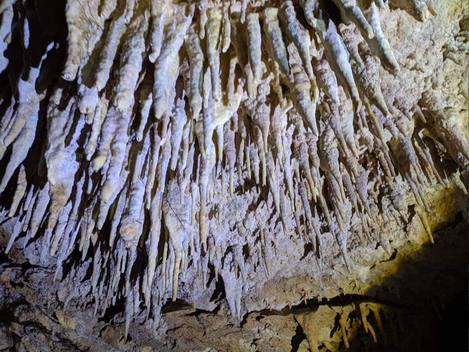
The siphon of about 60 meters in length with a penetrable drop 6 meters under the water, leads to a descending gallery that connects with a large cavity, circulated by an active river that discharges its waters into the Fuente de Valentín (PB-1 and PB-5). Currently under exploration by speleologists. This succession of rooms are beautifully decorated by speleothems of various forms, among which ceilings covered with stylized stalactites predominate.
About a hundred meters from the mouth, a new succession of descents brings us back to the theoretical level of the water, strongly changing the morphology of the cavity. After several lifts and descents the dimensions of the gallery increase. The two possible entrances to the Red de los Talegas are located in this area (flooded sectors, Red Gallery, Alicia Room, etc.). Continuing along the main gallery, you arrive at Paso Javi, a small rolling mill that short-circuits a rock barrier (this pass is very common to find it flooded), if it is under water, the pass is made ascending a strong ramp to the right of the pass , followed by a vertical descent -easy to overcome- that descends to the level of the main gallery, after the Javi Pass. The continuation is obvious, you just have to follow the gallery, yes, with the odd narrowing and passage between blocks, until you reach the Gallery of Levels, easy to recognize by the calcite sidewalks that run through all the walls, blocks and other speleothems.
From here a new comeback between blocks and streams leads to the head of some escarpments. A few meters before reaching them and on the left wall several narrow passages open up, between blocks, which reach the base of these escarpments. You are entering the Zebra Gallery, named for the successive levels of floating calcite that have been fixed on the clay walls; corresponding to different stages of flooding.
Source: Inventory of Georecourses of Andalusia. Ministry of Environment. Junta de Andalucía.
Follow us #JaénParaísoInterior


