


Vía Verde del Guadalimar
From the gallery forest of the Guadalimar river to the olive plain of the Guadalquivir.
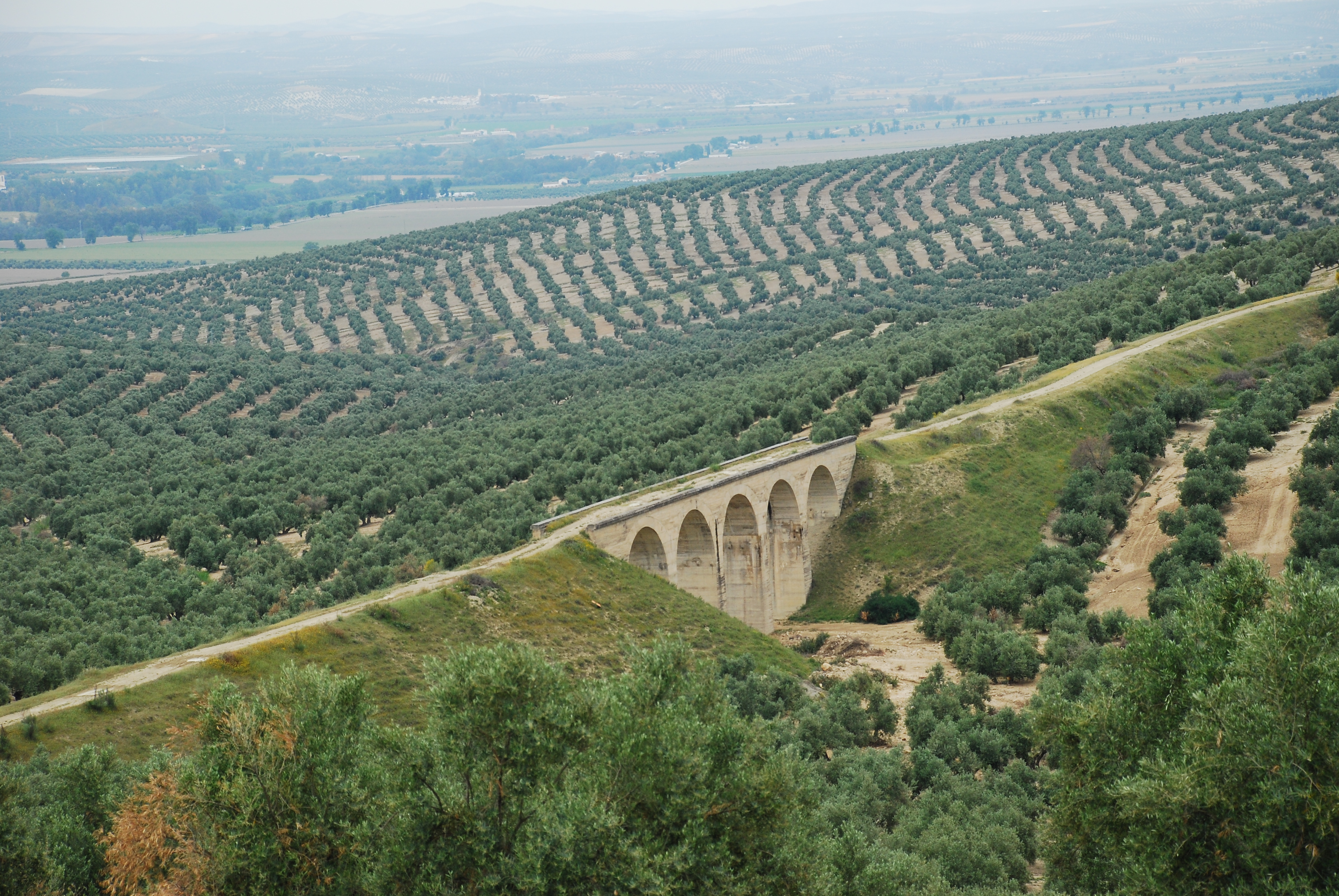
This road runs almost entirely between fields of olive groves, approaching the Guadalimar river in its northern half, which allows you to enjoy exuberant views. The route is dotted with numerous viaducts and tunnels that circumvent steep ravines and high hills.

TYPE OF TRAIL
Path
Difficulty
Moderate (For the distance to travel)
START POINT
El Camino comienza en las proximidades de la estación de ferrocarril de Linares-Baeza, en el paraje de Arquillos (Linares)
ARRIVAL POINT
Paraje de Horcajo (Begíjar)
TOTAL DISTANCE (IN KILOMETERS)
15,30 Km
Type of firm
Double firm of compacted gravel and asphalt treatment
DIFFICULTY. ASSESSMENT ACCORDING TO METHOD MEASURE
0
MEDIO.
Severity of the natural environment
0
Itinerary
Orientation in the itinerary
0
Displacement
Difficulty moving
0
EFFORT.
Amount of effort required
TYPE OF ACCESSIBILITY
It can be traveled on foot, by mountain bike and on horseback
TYPE OF CARTOGRAPHY
Download Cartographic Information Brochure: Military Map of Spain. Scale 1: 25,000 Sheet 905-IV Official Road Map. Ministry of development.
TIME OF THE YEAR
All year
SIGNALING
Sí
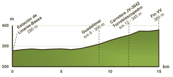
HEIGHT PROFILE
TUNNELS: 7 with lighting
METALLIC VIADUCTS 3
METALLIC CATWALKS: 2
MUNICIPAL TERMS BY WHICH IT RUNS
Torreblascopedro Ibros Lupión Begíjar LinaresREGION / S TO WHICH IT BELONGS
Linares La Loma y Las VillasNATURAL ENVIRONMENT
Olive field, gallery forest of the Guadalimar river, valley of the Guadalquivir river and beautiful panoramic views of Sierra Mágina.
RECREATIONAL OR SPORTS AREAS NEAR THE TRAIL
6 areas with benches, picnic tables, wastebaskets and bike rack.
OTHER INFORMATION OF INTEREST (ARCHITECTURAL OR HISTORICAL-CULTURAL, GEOLOGICAL-ECOLOGICAL)
This Greenway has 4 Protected Natural Areas located within a radius of less than 5 km: The ZIC Río Guadalimar, Laguna Grande, and the Lower Section of the Río Guadalimar and Alto Guadalquivir (Natura 2000 Network) and the Natural Monument El Piélago.
RECOMMENDATIONS
Some entrance trenches to the tunnels get waterlogged and muddy in the rainy season.
POINTS OF INTEREST
Linares: Monumental complex, mining and industrial heritage, ruins of the Iberian-Roman city of Cástulo and interpretation centers of the Mining Landscape and Metallurgy in Linares.
Ibros: Cyclopean Wall (Historic Artistic Monument) and Church of San Pedro and San Pablo.
Lupión: Defensive tower (13th century) and Asunción church.
Torreblascopedro: Parish of San José.
Begíjar: Church of Santiago Apóstol, Arab tower, front of the town hall and episcopal palace.
DESCRIPTION
This Greenway was inaugurated in December 2011, it highlights a beautiful viaduct that flies over the waters of Guadalimar in the vicinity of the Linares-Baeza Station. The first kilometers run parallel to the river, to later enter extensive olive groves. During the tour we will find several tunnels that bridge the slopes.
The layout of this greenway is part of what was a great civil engineering project that sought to link the city of Utiel (Valencia) and the Linares-Baeza Station.
Links of interest
Source of information
Follow us #JaénParaísoInterior


