


Subida a la Pandera
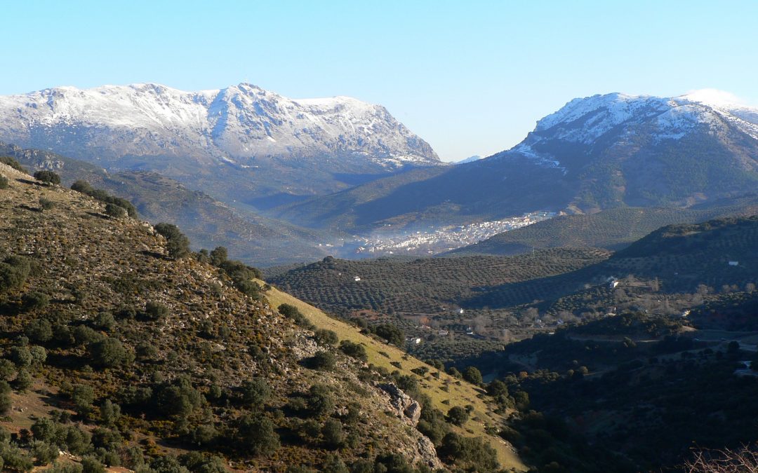
The area has abundant snow wells, used until the 20th century, from which snow was extracted that would later be transformed into ice, to be used for medical purposes and as water supplies. Alto de La Pandera is a great viewpoint of the entire province of Jaén and other surrounding areas. Thus, and in clear sky conditions, it is possible to see the Sierra Nevada and the Sierra de Alhama (Granada), the Cordoba subbética mountain range, the Ronda mountain range and the Malaga Mountains, the Alpujarra in Almería and even Gibraltar.
TYPE OF TRAIL
Narrow paved and signposted road.
Difficulty
Alta
ARRIVAL POINT
The tour ends at the top of La Pandera, right where the barracks is located, which, taking advantage of its strategic position, was the headquarters of a military detachment specialized in communications.
HEIGHT
1.872 m
TOTAL DISTANCE (IN KILOMETERS)
8300
ESTIMATED RUN TIME
7 hours 8 minutes
SLOPE
1217 m
1217 m
DIFFICULTY. ASSESSMENT ACCORDING TO METHOD MEASURE
0
MEDIO.
Severity of the natural environment
0
Itinerary
Orientation in the itinerary
0
Displacement
Difficulty moving
0
EFFORT.
Amount of effort required
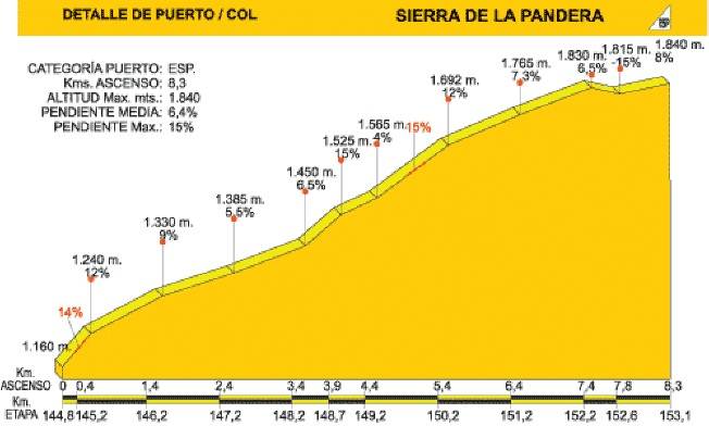
HEIGHT PROFILE
MUNICIPAL TERMS BY WHICH IT RUNS
Castillo de Locubín Valdepeñas de Jaén Los Villares JaénREGION / S TO WHICH IT BELONGS
Jaén Sierra SurOTHER INFORMATION OF INTEREST (ARCHITECTURAL OR HISTORICAL-CULTURAL, GEOLOGICAL-ECOLOGICAL)
The access road to Alto de La Pandera is closed to vehicle traffic so it is necessary to request the gate key at the Valdepeñas de Jaén Town Hall (Tel. 953 31 01 11) or Los Villares (Tel. 953 32 00 05).
DESCRIPTION
The path that leads to La Pandera, which is accessed from the A-6050 Jaén-Valdepeñas de Jaén-Castillo de Locubín road, through a detour to the left located at P.K. 24,500, is a narrow asphalt route built to access the military installations that are at its top. In recent years it has become a must for La Vuelta Ciclista a España, being considered one of the queen mountain stages. During the first 3 km. On an ascending route, we are accompanied by the typical landscape of the Mediterranean forest, of abundant scrub dotted with holm oaks.On reaching a quarry, the first important ramps appear, with slopes of around 15% changing the vegetation as the altitude increases: lavender, thyme, gorse, hawthorn, rosemary, thistle ... The road, still winding, is getting harder and harder and offers cyclists the first panoramic views of the landscape. The environment progressively becomes more arid but the visual basin widens considerably and the views of Los Villares, Valdepeñas de Jaén or the capital itself, surrounded by olive groves, are impressive.
Follow us #JaénParaísoInterior


