


Refugio de Majalserbal - Refugio Casa Forestal de La Zarza

This stage takes place in an almost completely unpopulated area and allows you to enjoy great landscape contrasts. From the steep head of the Aguascebas de Gil Cobo we climb the impressive Lancha de la Escalera, from which we will see most of the Sierra de Las Villas, the Loma de Úbeda, Sierra Mágina, the Sierra de Cazorla and even Sierra Nevada. We will cross the Jabalcaballo Plain, a plateau between 1,400 and 1,500 meters above sea level with scant trees, which constitutes one of the most unique and difficult means in which humans settled to take advantage of the fresh grasslands. From the top of Piedras Rubias we will descend, walking along an old Roman road, to the wooded slopes of the Guadalquivir Valley, where the shelter of the forest house of La Zarza is located.
The most important elevations that mark our route are the Morrón del Cerezo, Peña Corva, El Pardal and the Caballo de La Zarza, whose altitudes range is between 1477 and 1587 meters. The forests of black and black pines are interspersed with centennial oak groves of gall oak, juniper, juniper and in some small section with boxwood. The fauna richness of the area along the route is notorious, since in addition to vultures and other raptors we will find deer, fallow deer, mountain goats and wild boars.
Technical information
Route Name Rutas Bosques GR247
Rutas Bosques GR247 9: Refugio de Majalserbal - Refugio Casa Forestal de La ZarzaHUSO 30S
Refugio Majalserbal: x509198 y4214007
Refugio casa forestal La Zarza: x507476 y4206240
Refugio Majalserbal: x509087 y4213800
Refugio casa forestal La Zarza: x507365 y4206033
TOTAL DISTANCE (IN KILOMETERS)12950
Asphalt or cement section 0 %
Section of track or forest road or promenade 62,39 %
Senda section 37,61 %
tramos-de-Vía-pecuaria 0 %
ESTIMATED RUN TIMEO
3 h 42 minMAXIMUM SLOPE276 m
DIFFICULTY. ASSESSMENT ACCORDING TO METHOD MEASURE
2
MEDIO.
Severity of the natural environment
2
Itinerary
Orientation in the itinerary
2
Displacement
Difficulty moving
3
EFFORT.
Amount of effort required
TOTAL DISTANCE (IN KILOMETERS) 19540 M
Start
From Mogón (Villacarrillo): we leave by the Las Villas JH-7155 road, we take the track to the right at the Aguascebas de Gil Cobo river and we deviate again to the right along the track indicated as "Carril a Peña Corva", to Majalserbal. From Villanueva del Arzobispo: we leave by the A-6202 road, we continue along the Las Villas JH-7155 road, then to our left along a track in the Aguascebas de Gil Cobo river and we turn right along the track indicated "Carril a Peña Corva ”, to Majalserbal
Final
There is no public access to road traffic.
CYCLABILITY
Short sections with steep slopes in the Piedras Rubias area.
WATER POINTS
Majalserbal Refuge, Fuente del Tejo watering hole, near the Casa Forestal La Zarza Refuge.
PREFRESHING POINTS
On the trail: There is no
Near the trail: No
Rutómetro
Majalserbal Refuge
Between black pines and bojedas we begin stage 9 of the Bosques del Sur trail, ascending a wide forest track in good condition, which runs over the large rock plate that forms the Lancha de la Escalera. A little further up we cross the Hoya de las Zamarrillas, and the vegetation that we find from there is more typical of the high mountains, where the trees tend to disappear due to the harsh winter conditions and the lack of fertile land.
Ladder Boat
From this large natural balcony that faces west, we will contemplate a large part of the province of Jaén, with towns such as Iznatoraf, Úbeda and Baeza, among others, as well as a large extension of the western area of the natural park. Nestled down between the pine forests, although very close to the boat, you can see the small reservoir of the Aguascebas, belonging to the Guadalquivir watershed. Our path, which is known as the road to the Cañada del Avellano, descends slightly from here, leaving the Morrón del Cerezo on the left.
Yew Fountain Trough
On the right, in a ravine, this fountain is 100 meters from the track we are traveling on. It is convenient to fill the canteen, because until the end of the route we will not find another point with water. The trough tells us that it is a livestock area par excellence, whose lands, at a remarkable altitude, constitute canyons and plains with rich pastures.
At 600 meters from the source, we will cross the small Collado del Muerto, and from here the track runs practically flat, bordering the beautiful Jabalcaballo plain, with few slopes until kilometer 8. On the right, in the ravines, we find some buildings that correspond to small isolated farmhouses in different states of conservation.
Track bifurcation
We must continue the track to the left, as it descends to the right towards some of these farmhouses, located next to the Arroyo de la Cañada del Avellano. Following our route we leave the Cortijo de la Berraza on the right, and also to the right, about 700 meters away, another access track to these farmhouses that we will discard.
Track bifurcation
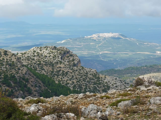
We leave another of the tracks on the right that go into the Jabalcaballo plain. We must continue along the left track to find, in just under 300 meters, another new fork, and in this case we must turn to the right. To our left we see Peña Corva, which is a rocky peak devoid of vegetation whose altitude is 1559 meters. It is highly recommended to ascend to this summit as it is a privileged viewpoint over the Sierra de Las Villas and the Guadalquivir Valley.
End of Track in El Pardal
We reach a point where the track ends, just in front of the access door to the Cortijo del Pardal, currently inhabited, far from any conventional way of life. Our path, from here, continues to maintain a southwesterly direction, and passes by some groves of pine groves, leaving the farmhouse on the right, and parallel to the fence that delimits your property.
Collado
We come to a small hill where there is a crossroads. The one that starts to the left, delimited with stone on both sides, soon gets lost, when reaching a field that suffered a fire, on the mount of Torre del Vinagre. We continue ahead and on a slight climb. Towards the west we can see the geodesic vertex of El Pardal at an altitude of 1580 meters. This section runs along an old bridle path of considerable width and delimited with stones on both sides, which shows the importance that this communication route had in the past.
Alto de Peñas Rubias
At 1500 meters of altitude we cross a hill, from which the landscape changes radically. The tree vegetation under us is much more abundant, also appearing some boxwood, junipers and junipers. To the left we have the rocky wall that gives its name to the place, on which colonies of vultures and corvids settle. Continuing the descent, at the foot of the path, there is a large black pine, with a hollow, burned hole at the base of the trunk. Its cause is an ancient custom of the locals, who, to warm up when everything was wet, made a superficial wound to the pine, so that the resin flowed little by little. A fire was lit in the hole and thanks to the resin that had flowed they could be heated for a few minutes before continuing with the march. This could be very important when humidity, water or snow made it difficult to light a fire.
The Asperones
400 meters after having crossed the top, we come out to some clearings in the forest that extend over several hills, to the right, where there are remains of old buildings that served the ancient inhabitants of the area. From here, the forests that we find begin to diversify. The centenary oaks (gall oaks) compete with the pines for space, and the whole makes up a forest much richer in food for the fauna, with acorns, pine nuts and other fruits of the undergrowth. Some maples appear and dot the landscape. The views towards the Guadalquivir Valley are very wide, with great mountains covered with forests, among which the escarpments and slashed cliffs of El Banderillas stand out on the other flank.
At kilometer 10.5 we leave Morra de los Pinos Blancos on the right and a little further on the path, which until here ran slightly downhill, ascends a few meters, zigzagging to gain height. The path is getting wider, and at some point it resembles a forest track.
Collado de la Nava del Puesto
After the slight climb, we come to a hill, where there is a crossroads of paths. Towards the right, and delimited with stones, one of them looks out over some cliffs from which several valleys can be seen on the west slope. Next to the junction, to the right, we see the ruins of what was an old forest guard shelter.
Our route continues to the left, now along a narrow forest track, again descending until the end of the stage, crossing a fertile nava above 1400 meters of altitude, where we find botanical representatives more typical of alpine bioclimatic floors, leafy It expires, and that we sometimes find in the Mediterranean mountains, and that here they are well adapted by the microclimatic conditions of high altitude, in this part of the Andalusian mountains.
During the descent, it is common to observe fragments of ammonites, cephalopod fossils that used to have a spiral shell wound on itself, which became extinct more than 65 million years ago and which indicate the marine origin of the rocks that make up these mountains. The regulations for protected areas prohibit the collection of these fossils, but do not stop photographing them.
Track to the Vinegar Tower
We go out onto a wider track, which we must take to the right to reach the end of the stage in 100 meters. To get to the source, we must turn left along the track for another 150 meters. It cannot be seen from the road, but the place is easy to identify because we will see on our right a wide clearing, quite flat and with remains of small dry stone terraces, made at the time to flatten the ground and facilitate its tillage. We cross the clearing to a small stretch and there we will find a wooden turn and another work trough in the fountain.
La Zarza Forest House Refuge
We reach the end of the stage, which in turn is the starting point for two others: stage 2 of the GR 247.2 variant towards Coto Ríos and stage 10 towards La Iruela. The forest house is located on a hill with unbeatable views of the entire Guadalquivir Valley and has stone benches next to the information panels for each stage. Part of its building is used by flocks of sheep or goats as a place of refuge, and another part has been enabled as a refuge.
From the forest house there is a signposted path that is not part of the Bosques del Sur path, but whose route is highly recommended, as mentioned at the end of the description of said stage 2 of the GR 247.2 variant.
Additional information
The quejigo, the majestic and welcoming tree
Throughout this stage we will see some centenary gall oaks in the Los Asperones area. The tree commonly known as gall oak (Quercus faginea) is called robre or oak in these mountains, a name that is generally reserved for sessile oak or carballo, typical of the north of the Peninsula. Like all quercíneas, its fruit is an acorn, and therefore it has as relatives in the park the holm oak or holm oak, the melojo and the kermes oak. It can reach 20 meters in height, its trunk is straight and its leaves similar to those of the holm oak, but more flexible and clear, remaining withered on the branches for some time before the new annual generation is born. Walnut-sized brown balls abound in it. They are the galls, an example of collaboration between a plant and an insect, that the gall oak produces as a reaction to the laying of eggs of a small wasp. The larvae develop well protected inside, from which they will emerge by making a small hole.
It withstands very well thermal contrasts and the rig ...
The quejigo, the majestic and welcoming tree
Throughout this stage we will see some centenary gall oaks in the Los Asperones area. The tree commonly known as gall oak (Quercus faginea) is called robre or oak in these mountains, a name that is generally reserved for sessile oak or carballo, typical of the north of the Peninsula. Like all quercíneas, its fruit is an acorn, and therefore it has as relatives in the park the holm oak or holm oak, the melojo and the kermes oak. It can reach 20 meters in height, its trunk is straight and its leaves similar to those of the holm oak, but more flexible and clear, remaining withered on the branches for some time before the new annual generation is born. Walnut-sized brown balls abound in it. They are the galls, an example of collaboration between a plant and an insect, that the gall oak produces as a reaction to the laying of eggs of a small wasp. The larvae develop well protected inside, from which they will emerge by making a small hole.
It withstands very well thermal contrasts and the rigors of cold, heat and summer drought, having requirements similar to those of holm oak or holm oak, although in relation to this it needs somewhat cooler and deeper soils. In addition, it is more demanding in humidity and less resistant to insolation and heat.
The ecological importance of the well-preserved gallbladder is enormous, due to its ability to increase soil fertility, due to the richness of fauna in its dense undergrowth and due to the beauty of the landscapes that it forms. However, it has been one of the hardest hit trees both in our region and outside of it, felled to turn its wood into firewood or to use it in construction, and burned to open pastures to livestock, so many of its old formations they are degraded. But when it is allowed to reach its full splendor, even in difficult terrain, its majestic demeanor gives off a magic that is a symbol of the fertile past of the park's mountains and of what they can once again be part of their forests if allowed to Nature give the best of herself.
We can see gall oaks in various stages of the GR 247, highlighting the great gall quejigar in the Guadalentín Valley, at stage 14.

Follow us #JaénParaísoInterior


