


AR Peña del Olivar - Segura de la Sierra

This stage of the Bosques del Sur trail allows you to enjoy the wide variety of landscapes of the low mountains of the natural park, in which pine forests alternate with Mediterranean understory, olive groves and small towns and villages.
In the surroundings of Siles, we will see a beautiful mosaic of pine forests and olive groves and we will enter one of the best Aleppo pine forests in the natural park, where you can see and touch two gigantic examples of Aleppo pine included in the Inventory of Singular Trees of Andalusia.
We will be able to approach the remains of the small Puentehonda castle, half hidden in the thick of the forest and walk along a delicious bridle path that starts from the recreational area of ??Los Estrechos, from which we can see the Hispanic Muslim towers of Santa Catalina and the undulating olive groves of the Trujala valley.
The day could not end better, because the stage ends in Segura de la Sierra, a small town declared a Historic-Artistic Complex, where you can enjoy its spectacular location, its castle - an essential visit - and its popular architecture.
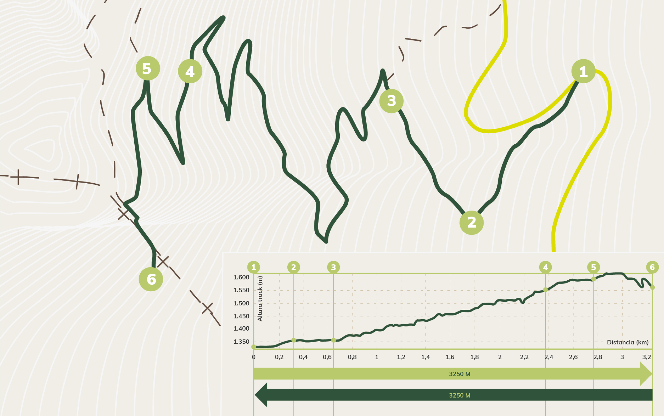
Map and profile
Technical information
Route Name Rutas Bosques GR247
Rutas Bosques GR247 1: AR Peña del Olivar - Segura de la SierraHUSO 30S
Peña del Olivar: x536888 y4247085
Segura de la Sierra: x530520 y4239383
Peña del Olivar: x536776 y4246877
Segura de la Sierra: x530408 y4239175
TOTAL DISTANCE (IN KILOMETERS)19540
Asphalt or cement section 0,31 %
Section of track or forest road or promenade 52,20 %
Senda section 47,49 %
tramos-de-Vía-pecuaria 0 %
ESTIMATED RUN TIMEO
6 h 45 minMAXIMUM SLOPE331 m
DIFFICULTY. ASSESSMENT ACCORDING TO METHOD MEASURE
2
MEDIO.
Severity of the natural environment
2
Itinerary
Orientation in the itinerary
2
Displacement
Difficulty moving
3
EFFORT.
Amount of effort required
TOTAL DISTANCE (IN KILOMETERS) 19540 M
Start
We access the Peña del Olivar through the municipality of Siles, through the A-310
Final
To Segura de la Sierra, through the JA-9117 from Orcera; or by the JA-9118, if we go from the A-317
INTERMEDIATE POINTS
PLACE
POSITION
TYPE OF ROAD
Km 5,3
Forest track
Km 10
Asphalt forest track
Km 12,2
Asphalt forest track
CYCLABILITY
Steep slopes and rocky soils in short sections of the access path to Segura de la Sierra.
WATER POINTS
Peña del Olivar Recreational Area, Noguerón Fountain, Puente Honda Recreational Area, Pilarillo Forest House Fountain, Los Estrechos Recreational Area, Segura de la Sierra.
PREFRESHING POINTS
On the trail: Segura de la Sierra
Near the trail: Siles, Benatae and Orcera
LINKS WITH OTHER TRAILS
PR-A 177, PR-A 179, PR-A 180, PR-A 79 GR-147, 147.1
Rutómetro
Peña del Olivar Recreational Area
The route begins at the Peña del Olivar Recreational Area, located just 2 kilometers from the town of Siles on the Las Acebeas road. It is one of the best equipped public use facilities in the park that has tables, a fountain, children's games, a bar, a terrace, etc., and in summer even an exceptional natural bathing area. It is also advisable to visit its Botanical Collection, where you can see many of the most representative species of the flora of the natural park. The path starts under a large panel with a road sketch painted on a stone wall. Along the forest track that goes to the right, in its first kilometers we will contemplate a mosaic of olive groves mixed with pine forests.
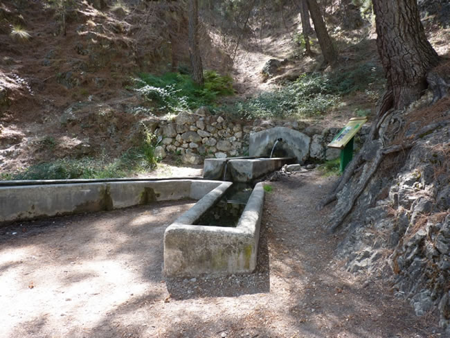
Fountain of the Noguerón
Just 1 kilometer from the beginning, we find the Fuente del Noguerón on our left. The limestone soil slowly and continuously filters the water that falls during the humid months as if it were a large rocky sponge, releasing it through sources like this when the water meets an impermeable layer of soil.
A few meters from the source we leave on our left the PR-A 175 Circular de la Peña del Olivar trail and stage 21 of the Bosques del Sur trail itself, which would take us to the Era del Fustal refuge. We will continue along the track in front, immersed in one of the best Aleppo pine forests of the natural park, under which grows a closed undergrowth with holm oaks, strawberry trees and durillos (Viburnum tinus).
Fork
We come to a fork in the tracks and we must take the one on the right that goes gently downhill towards the Morles river valley. The forest is becoming more and more authentic and proof of this is that 2 kilometers from the aforementioned fork we will find on our right, at the foot of the track, two gigantic and venerable examples of Aleppo pine. Both are included in the Inventory of Singular Trees of Andalusia with the names of Pino de los Barrancos de Puentehonda and Pino del Cerro Bucentaina respectively. The latter is 32 meters high and 4.5 meters in diameter at its base.
A little further on we leave a small path on our left, not very well preserved, which corresponds to the PR-A 79, in the direction of the ruins of the Castillo de Puente Honda. However, if we do not want to deviate, we can see it a little further on, to our left and in the upper part between the pine forests. It is a small medieval watchtower post on the slope of Cerro Bucentaina, made up of two towers built on two twin rocks and joined by a wall.
Puentehonda crossing
We come to a crossroads with a forest track that is much wider than the one we have traveled. Towards the left it leads to the charming village of La Hueta, but our route turns to the right to travel along this track for just 200 meters and turn left again along another track, arriving immediately at the village of Puentehonda, which we will have already observed. when we went down to the valley and that is on the other side of the small river Morles. Next to the village there is a pleasant recreational area with a fountain. In this area the landscape has already been more transformed by human beings and there are small olive groves that are mixed in some cases with walnut trees, fruit trees and small orchards.
Our route continues along a forest track that is a little before reaching the recreational area. It is narrower and steeper than the previous one, and it takes us back into the pine forest. The Aleppo pine forest gives way to the black pine, more adapted to these altitudes, dotted with some holm oaks and oaks (gall oaks). On our left, at the top, you can see the Calar de Navalperal and on our right, perched on the rock, the Peñalta guardhouse.
Port of Siles
The climb culminates in the Port of Siles, very close to 1,100 meters of altitude. At this point we can deviate from our route to travel the PR-A 180, which is also part of the Bosques del Sur trail and which will take us to Peñalta, a 1400-meter summit that is a splendid natural viewpoint over the Guadalimar and Trujala Valleys. . The climb to Peñalta is derivation 1 of this GR. More information on page 281.
Continuing towards Segura de la Sierra from the Port of Siles, we begin a descent along the path towards the El Pilarillo forest house that we find just 600 meters below. There is a fountain right where the houses are located, at the foot of the road. To our left and in parallel runs an asphalt forest track that we will cross later. Afterwards, our path crosses a wide dirt track, cutting short to finally return to it.
Los Estrechos Recreational Area
We arrive at the Los Estrechos Recreational Area that we will find on our left. It has a wooden roof with tables to eat, as well as a magnificent fountain and shades. If we continue along the track that we bring, we would soon arrive at the large municipal swimming pool of Amurjo, 1.2 kilometers away, of exceptional dimensions and surrounded by pine forests and rocky areas. After another 0.8 kilometers we will reach Orcera entering through its charming old town.
To continue our stage from Los Estrechos we take a delicious bridle path. Walking under the Aleppo pines, with very little unevenness, we will see Mount Peñalta, until the perspective opens towards Orcera, the Spanish-Muslim towers of Santa Catalina and the undulating olive groves of the Trujala valley.
Later, after passing through an olive grove, we gain altitude along the traditional path that for centuries was traveled by people who circulated between the towns of Orcera and Segura de la Sierra, and which is very panoramic in some sections. The unmistakable mass of El Yelmo, the most emblematic mountain in this area of ??the natural park, appears before our eyes, and further south, the line of peaks of the Sierra de Las Villas.
Segura de la Sierra
The stage ends in Segura de la Sierra, a small town declared a Historic-Artistic Site, whose view already falls in love since we began to see it from the Bosques del Sur path, with its white houses adhering to the profile of the mountain crowned by a castle of Muslim origin , which houses the Thematic Space of the Border Territory. Strolling leisurely through its narrow streets, discovering the details and corners of its popular architecture and being ecstatic with the panoramic views that open in all directions is one of the most rewarding experiences that the Bosques del Sur trail has in store. Visiting the town arriving by vehicle is pleasant for everyone, but reaching it on foot will allow us to feel its essence more authentically, since the historical origin of its location was defensive, and therefore the altitude and the difficulty of access constitute the original sense of Segura de la Sierra.
In this same town, near the access to the castle and the exit road towards Siles-Pontones (Ctra. De La Cumbre), the GR offers you an alternative to the main route: the GR 247.1 variant (more information on page 231), that in two days connects directly with stages 19 and 20, being able to close a complete circuit with the northern stages of the GR 247.
Additional information
The Segura Common and its Land
Orcera, a town very close to the route of this stage and that can be seen when you climb towards Segura de la Sierra, was the scene in the 16th century of an event that is still considered emblematic in the history of the Sierra de Segura today. It is about the elaboration of the Ordinances of the Common of Segura and its Land, signed in 1580 by the representatives of the Segura councils in the Franciscan convent of Santa María de la Peña.
Once Granada was conquered by the Christians in 1492, the Sierra de Segura, which for centuries had been a frontier land of struggle between Christians and Muslims, is experiencing a period of stability, prosperity and an increase in population. Most of the territory was occupied by the mountains and pastures, pine wood being the main wealth, because already then the wood circulated through the rivers supplying the entire kingdom.
The inhabitants themselves were aware that foreign greed for their wealth was a danger to the survival of their economy, which is ...
The Segura Common and its Land
Orcera, a town very close to the route of this stage and that can be seen when you climb towards Segura de la Sierra, was the scene in the 16th century of an event that is still considered emblematic in the history of the Sierra de Segura today. It is about the elaboration of the Ordinances of the Common of Segura and its Land, signed in 1580 by the representatives of the Segura councils in the Franciscan convent of Santa María de la Peña.
Once Granada was conquered by the Christians in 1492, the Sierra de Segura, which for centuries had been a frontier land of struggle between Christians and Muslims, is experiencing a period of stability, prosperity and an increase in population. Most of the territory was occupied by the mountains and pastures, pine wood being the main wealth, because already then the wood circulated through the rivers supplying the entire kingdom.
The inhabitants themselves were aware that foreign greed for their wealth was a danger to the survival of their economy, which is why the Ordinances were drawn up in 1580, the objective of which was to ensure that the wealth generated in the region reverted to its own inhabitants. The Ordinances, based on the Cuenca Jurisdiction, were the regulating norm of the coexistence of the mountain people and of the economic activities that were the sustenance of the region, especially wood and pastures. The collection of fruits and seeds, hunting, fishing and the conservation of roads, fountains and caves as common goods were also regulated.
They had enormous significance for two centuries as a regulating instrument of trade and the use of natural resources, creating a framework of ecological rationality appropriate to the criteria, needs and knowledge of the time. When the walker quenches his thirst in some source, remember what more than four centuries ago article 50 of the Ordinances prescribed:
«Item we order and we order that because the springs are clean and their springs for the drinking of the people and their service and use that no person drink pigs or work other dirt in them under penalty of six hundred maravedíes (...) and remain clean ( ...) two measuring rods around it under the said penalty because it is in the public good ”.

Follow us #JaénParaísoInterior


