


Zona de Acampada Controlada Fuente de Los Cerezos - Refugio Casa Forestal La Parra

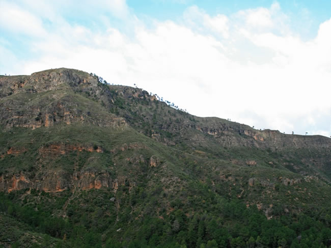
This stage runs through the Sierra de Las Villas, lonely, rugged and rugged. We will see large geomorphological formations with the profiles so characteristic of this region, such as the Piedra del Emjambre, the Lancha del Tosero and the Caballo de La Albarda. It is one of the most original geological landscapes in the natural park known as the scale structure. The compressive forces that forged the formation of the Betic Cordillera did not lead to the folding and curvature of the strata, as in other places in these mountain ranges, but rather fractured and rode over one another, giving rise to successions of oblique slopes and very cliffs. abrupt and vertical.
In some places, such as Tosero, we will enjoy great panoramic views both towards La Mancha and towards the spectacular elevations of Las Lagunillas, in the Sierra de Las Villas itself. The griffon vulture and the mountain goat are very abundant.
The short ascent to Caballo Torraso, which is described in the place corresponding to derivation 3 of the Bosques del Sur trail, is an absolutely essential complement to this stage, as it is one of the points with the best views of the natural park. The route ends at the shelter set up in the old La Parra forest house, located in an idyllic setting.
Technical information
Route Name Rutas Bosques GR247
Rutas Bosques GR247 7: Zona de Acampada Controlada Fuente de Los Cerezos - Refugio Casa Forestal La ParraHUSO 30S
ZAC Fuente de los Cerezos: x513403 y4224044
Refugio Casa Forestal La Parra: x509495 y4218432
ZAC Fuente de los Cerezos: x513291 y4223837
Refugio Casa Forestal La Parra: x509384 y4218225
TOTAL DISTANCE (IN KILOMETERS)14270
Asphalt or cement section 6,31 %
Section of track or forest road or promenade 83,74 %
Senda section 9,95 %
tramos-de-Vía-pecuaria 0%
ESTIMATED RUN TIMEO
4 h 27mMAXIMUM SLOPE586 m
DIFFICULTY. ASSESSMENT ACCORDING TO METHOD MEASURE
2
MEDIO.
Severity of the natural environment
2
Itinerary
Orientation in the itinerary
2
Displacement
Difficulty moving
3
EFFORT.
Amount of effort required
TOTAL DISTANCE (IN KILOMETERS) 19540 M
Start
The Fuente de Los Cerezos Controlled Camping Area is accessed, both from Villanueva del Arzobispo and from El Tranco, by the A-6202 road and then by the Las Villas JH-7155 road, at the beginning passing through the Oil Charco .
Final
The Casa Forestal La Parra Refuge is accessed from Mogón by the Las Villas JH-7155 road. From Villanueva del Arzobispo it is accessed by the A-6202 road, and then by the aforementioned Las Villas road from the Puente de Los Agustines.
INTERMEDIATE POINTS
PLACE
POSITION
TYPE OF ROAD
Km 12,7
Highway
CYCLABILITY
Between Arroyo Martín and El Tosero the forest track has sections of extreme slope. The last section of the Stage, from the Collado del Ojuelo to the Refugio, the path is poorly defined and the terrain is very uneven.
WATER POINTS
Controlled Camping Area Fuente de los Cerezos, fountain on the trail that descends to Collado El Ojuelo, Casa Forestal La Parra Refuge
PREFRESHING POINTS
On the trail: There is no
Near the trail: No
Rutómetro
Los Cerezos Fountain Controlled Camping Area
The route starts from this Camping Area in which there is a space reserved for those who go backcountry. The area has a wooden dining room and there is a fountain with abundant water a few meters away. We start along the small road to Las Villas on the left, surrounded by abundant vegetation in which the presence of oaks (gall oaks) stands out, and we walk along it for 700 meters. We find a forest track on the right. We take it and we go up in the middle of a pine forest of black pine with a lot of holm oak and juniper. It is common to find wild goats and wild boars in this area. Further on, Mount Caballo de La Albarda appears to our right, with its round shapes and gray and reddish walls, with the Piedra del Emjambre standing out, while on our left we have the elongated Lancha del Tosero. As we climb, species of the Mediterranean noble scrub appear, such as strawberry tree and barberry (Phillyrea latifolia), as well as boxwood, which has its largest expansion area in the natural park in the Sierra de Las Villas, and that we can see at the bottom of the ravine that we have on the right.
Fork
We come to a fork just before the track we are going on crosses the Arroyo Martín. We left it and took the one on the left, which has a steep slope. The vegetation here is already poorer, with only black pines with white rockrose and other low bushes. The road has cobbled sections with a very steep slope. The origin of these is the road infrastructure that was built to access the areas affected by a terrible fire that in 2005 devastated some areas very close to those that we travel in this stage, and that was caused by an unusual dry storm in which Hundreds of lightning struck without a drop of rain.
The Tosero
In this place we enjoy great views towards the rocky masses of the Sierra de Las Lagunillas that can be seen in front. We pass by the ruins of the Cortijo del Tosero, which we leave on the right, while below on the left we have the Arroyo María ravine. Also to the left, in the background, we can see the peaks of the Sierra de Segura that are on the other side of the great El Tranco reservoir, which we cannot see from here. The pine that we see here is already the laricio or salgareño, better adapted to this altitude.
A little further on, some extraordinary panoramic views open to the north towards La Mancha, in the province of Ciudad Real and, closer, the mountains on the right side of the Guadalquivir (which turns sharply west from the El Tranco dam), among which Los Mansegosos and Cañada de Los Caballeros stand out. At kilometer 4.4 our track reaches a pleasant area where it flattens out and soon ascends again with increasingly wide views. In the forest there are numerous albarradas made with trunks of the trees affected by the aforementioned fire, which are fixed horizontally to the ground to contain erosion and to function as a seed bank, in such a way that the natural regeneration of the vegetation is enhanced. .
Crossing with track
At this point there is a track to our left through which it is recommended to deviate about 700 meters until reaching a point from which spectacular panoramic views are dominated, looking to the east the rope of the Sierra de Las Lagunillas in which Los Almagreros stand out (1467 m) and La Plomera (1539 m). Back on our route, the track continues to climb, now with more trees, specifically black pine.
Derivation to Caballo Torraso
We find on the left the signposted start of derivation 3 of the Bosques del Sur trail that goes up to Caballo Torraso, at almost 1700 meters of altitude. This short route, of just over a kilometer, is described in another chapter of this guide and it is highly recommended to include its route in the day to put the icing on the stage, since from the guardhouse that perches on that aerial prop it enjoys exceptional horizons in all directions.
From the aforementioned crossing, our track begins to descend gently through the repopulated black pine forest, enlivened at some points by oaks (gall oaks) and boxwoods.From kilometer 10.5, good views open up again, seeing in front, shortly before get to the Collado del Ojuelo, the Cerro de Santa María with its forest hut on top.
Collado del Ojuelo
At this point we return to the road from which we started, turning left. There is a fountain on the right and, on the right side of the road, the Casas del Ojuelo de La Parra. Just 200 meters later we leave the road, taking a narrow ravine to the right that comes out just between the road and a track that we discard. The path to follow is wide and poorly defined, but it is well marked, always going parallel to the road and at some points very close to it. A few meters away there is a ravine, which we circumvent on the left. In this last section, totally different from the rest of the stage, we must highlight the abundance of blackberry juniper, which stars in some of the most representative landscapes of the Sierra de Las Villas.
At 700 meters after starting to walk through this ravine, we come to a flat area of ??ancient crops, seeing a tinada at the top left. A stream passes through the middle, which we cross, looking at the beacon that marks the route ahead. The stream happens to be on our right and embellishes the landscape with its riverside vegetation, dominated by ash trees, willows, box trees and reed trees. About 150 meters before reaching the end of the stage we pass the ruins of a farmhouse on the right, closing the landscape in front of the elevations of La Tejera and Lancha de la Cigarra.
La Parra Forest House Refuge
The stage ends in this old forest house, part of which has been rehabilitated as a refuge and has a fountain a few meters away.
Additional information
Sabinas, the beauty of tenacity
The sober junipers of the natural park rarely appear in tourist guides as a landscape claim. However, the junipers are one of its most relevant and characteristic plant formations, especially in the Sierra de Las Villas, as you can see at this stage. Although nothing spectacular, the juniper is one of the most attractive plant formations, at least for those who know how to appreciate the beauty of the twisted trunks of the blackberry juniper (Juniperus phoenicea) clinging with implausible tenacity to the most stark soils and taking advantage of the cracks from the rocks.
The junipers protect the soil from erosive landslides, hold the little land in which they grow and enrich it with organic matter, making possible the life of other plants alongside them and feeding many wild animals with their fruits that, in addition to being abundant, they remain available in the tree for a long time. They therefore fulfill a protective and nourishing role that no other tree or shrub can develop in such inhospitabl ...
Sabinas, the beauty of tenacity
The sober junipers of the natural park rarely appear in tourist guides as a landscape claim. However, the junipers are one of its most relevant and characteristic plant formations, especially in the Sierra de Las Villas, as you can see at this stage. Although nothing spectacular, the juniper is one of the most attractive plant formations, at least for those who know how to appreciate the beauty of the twisted trunks of the blackberry juniper (Juniperus phoenicea) clinging with implausible tenacity to the most stark soils and taking advantage of the cracks from the rocks.
The junipers protect the soil from erosive landslides, hold the little land in which they grow and enrich it with organic matter, making possible the life of other plants alongside them and feeding many wild animals with their fruits that, in addition to being abundant, they remain available in the tree for a long time. They therefore fulfill a protective and nourishing role that no other tree or shrub can develop in such inhospitable environments. In addition, the junipers are very welcoming to certain endemic species of the park, such as the Cazorla violet (Viola Cazorlensis).
Junipers often grow in the most hostile environment imaginable: very sun-damaged terrain on very strong slopes, stony soils or even vertical walls. The seeds almost always fall on infertile ground, so they only spread thanks to the birds and other animals that eat them and leave their stools in small crevices where there is some soil, which is enough for the seed to grab. Withstands thermal contrasts ranging from temperatures above 40 degrees to intense frosts, and withstands prolonged droughts, low humidity and the sharpest winds. She is, in short, a born survivor.
The junipers are usually not very dense formations where salgareño pines, junipers, as well as some guillomos and rosemary appear loose. The black or black juniper has a shrubby appearance, although sometimes it reaches the arboreal one. Its crown is dense and its tiny leaves, very similar to those of the cypress and soft to the touch. When they are old or are very exposed to the winds, the logs are often twisted. The fruits are globose, green at first and finally reddish and shiny after ripening the following year.

Follow us #JaénParaísoInterior


