


This municipality is part of:
Guarromán
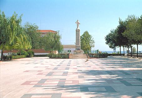
A town alongside the Andalusia motorway in the centre of the district of Norte. The majority of the municipal area is made up of unfarmed pastureland containing holm oaks, Mediterranean scrubland and replanted forests. Its origins go back to the 18th century when it was founded as part of the Sierra Morena colonisation initiative of King Carlos III.
Information
Data of interest
Tourist area Sierra Morena Cercano a P.N. Sierra de Andújar y P.N. Despeñaperros
Distance to the capital (km) 52
Altitude above sea level (m)350
Extensión (Km2): 96
No. of Inhabitants 2.724
Demonym Guarromanenses
Postal Code 23210
Tourist information
Ayuntamiento de Guarromán,, Calle Iglesia, 18
953615004
http://www.guarroman.es/ciudad/conoce-la-ciudad/guia-turistica-guarroman/
The town’s name comes from the location chosen for its foundation: the old Venta de Guadarromán.
The artisan pastries of Guarromán are particularly renowned, especially its puff pastries.
Highlights of the town’s historic heritage include the Iglesia Parroquial de la Inmaculada Concepción (Parochial Church of the Immaculate Conception), dating from the end of the 18th century, and the Pósitro de Labradores (Farmers’ Granary), built in 1789. Both were built in the architectural style of the so-called “New Towns”.
Source of information
Ayuntamiento de Guarromán
Imágenes
Contenido Audiovisual
? ![]()
Destinations
Festivities
Culture
Destinos
Culture
Festivities
Culture


Plan your trip
Plan your trip
SEE MORE
An error occurred while processing the template.
Syntax error in template "20101#20127#1641310" in line 8, column 44:
Unknown built-in: "Longitud". Help (latest version): https://freemarker.apache.org/docs/ref_builtins.html; you're using FreeMarker 2.3.29.
The alphabetical list of built-ins:
abs, absoluteTemplateName, ancestors, api,
boolean, byte,
c, capFirst, capitalize, ceiling, children, chopLinebreak, chunk, contains, counter,
date, dateIfUnknown, datetime, datetimeIfUnknown, default, double, dropWhile,
endsWith, ensureEndsWith, ensureStartsWith, esc, eval, exists,
filter, first, float, floor,
groups,
hasApi, hasContent, hasNext, html,
ifExists, index, indexOf, int, interpret, isBoolean, isCollection, isCollectionEx, isDate, isDateLike, isDateOnly, isDatetime, isDirective, isEnumerable, isEvenItem, isFirst, isHash, isHashEx, isIndexable, isInfinite, isLast, isMacro, isMarkupOutput, isMethod, isNan, isNode, isNumber, isOddItem, isSequence, isString, isTime, isTransform, isUnknownDateLike, iso, isoH, isoHNZ, isoLocal, isoLocalH, isoLocalHNZ, isoLocalM, isoLocalMNZ, isoLocalMs, isoLocalMsNZ, isoLocalNZ, isoM, isoMNZ, isoMs, isoMsNZ, isoNZ, isoUtc, isoUtcFZ, isoUtcH, isoUtcHNZ, isoUtcM, isoUtcMNZ, isoUtcMs, isoUtcMsNZ, isoUtcNZ, itemCycle, itemParity, itemParityCap,
jString, join, jsString, jsonString,
keepAfter, keepAfterLast, keepBefore, keepBeforeLast, keys,
last, lastIndexOf, leftPad, length, long, lowerAbc, lowerCase,
map, markupString, matches, max, min,
namespace, new, nextSibling, noEsc, nodeName, nodeNamespace, nodeType, number, numberToDate, numberToDatetime, numberToTime,
parent, previousSibling,
removeBeginning, removeEnding, replace, reverse, rightPad, root, round, rtf,
seqContains, seqIndexOf, seqLastIndexOf, sequence, short, size, sort, sortBy, split, startsWith, string, substring, switch,
takeWhile, then, time, timeIfUnknown, trim, truncate, truncateC, truncateCM, truncateM, truncateW, truncateWM,
uncapFirst, upperAbc, upperCase, url, urlPath,
values,
webSafe, wordList,
xhtml, xml
1<#--
2Nombre: JPI - Lista contenidos para mapa
3Tipo : Evento
4<#include "/templates_SERVLET_CONTEXT_/0/global/cms/evento/lista-contenidos-para-mapa.ftl" />
5-->
6
7<script>
8console.log("Longitud: ${Longitud?exists ? Longitud.getData() : 'No existe'}");
9console.log("Latitud: ${Latitud?exists ? Latitud.getData() : 'No existe'}");
10console.log("Titulo: ${Titulo?exists ? Titulo.getData() : 'No existe'}");
11console.log("ImagenDestacada: ${ImagenDestacada?exists ? ImagenDestacada.getData() : 'No existe'}");
12</script>
13
14<#if (Longitud?exists) && (Latitud?exists) && (Longitud.getData()?? && Longitud.getData() !="" ) && (Latitud.getData()?? && Latitud.getData() !="" )>
15 <li
16 data-color=""
17 data-structure=""
18 data-longitud="${Longitud.getData()}"
19 data-latitud="${Latitud.getData()}"
20 data-title="${Titulo.getData()?default('Sin título')}"
21 data-image="${ImagenDestacada.getData()?default('')}"
22 data-url="">
23
24 <div class="img-miniatura" title="foto-evento" style="background-image:url(${ImagenDestacada.getData()})">
25 </div>
26 <span>
27 ${Titulo.getData()}
28 </span>
29 </li>
30
31 <script>
32 console.log("** Lista de contenidos para mapa datos existen");
33 </script>
34
35 <#else>
36 <script>
37 console.log("ERROR: No existe algun dato: ${Titulo.getData()} ${ImagenDestacada.getData()} ${Longitud.getData()} ${Latitud.getData()});");
38 </script>
39 </#if>


