


Refugio Era del Fustal – Área Recreativa Peña del Olivar

Going through this stage we will enter one of the most peculiar sanctuaries of nature in southern Europe: the holly forest of Las Acebeas. Most of the route is done along narrow traditional paths, and in many of them we will delight in splendid panoramic views.
The route passes through the curious Pozo de la Nieve, where snow used to be stored for use during the summer. Afterwards, a delicious flat path under the striking geomorphological formation of Piedra del Agujero while in the distance we made out the Calar del Mundo. Towards the end of the stage, we will enter another superb Mediterranean forest, that of Bucentaina, where strawberry trees abound. In the Peña del Olivar recreational area, where the stage ends, we can eat, rest and even take a good bath, in addition to visiting its interesting botanical collection.
Very near the end of the stage is Siles, a quiet mountain town located in the transition zone between the olive grove and the pine forest. From this town, which is the one located further north in the natural park, you can make numerous excursions, among which thos ...
Going through this stage we will enter one of the most peculiar sanctuaries of nature in southern Europe: the holly forest of Las Acebeas. Most of the route is done along narrow traditional paths, and in many of them we will delight in splendid panoramic views.
The route passes through the curious Pozo de la Nieve, where snow used to be stored for use during the summer. Afterwards, a delicious flat path under the striking geomorphological formation of Piedra del Agujero while in the distance we made out the Calar del Mundo. Towards the end of the stage, we will enter another superb Mediterranean forest, that of Bucentaina, where strawberry trees abound. In the Peña del Olivar recreational area, where the stage ends, we can eat, rest and even take a good bath, in addition to visiting its interesting botanical collection.
Very near the end of the stage is Siles, a quiet mountain town located in the transition zone between the olive grove and the pine forest. From this town, which is the one located further north in the natural park, you can make numerous excursions, among which those that go to the Puntal de la Ajedrea, the Laguna de Siles, the Calar del Mundo and the Valle del Your. From Siles it is also close to the popular source of the Mundo River and the Los Calares del Río Mundo y de la Sima Natural Park, already in the neighboring province of Albacete, where the magnificent GR 66 Tres Calares passes.
Stage 21 can be complemented with the 3.1-kilometer climb to the Navalperal calar by diversion 10, from where we will contemplate very extensive panoramic views.
Technical information
Route Name Rutas Bosques GR247
Rutas Bosques GR247 21: Refugio Era del Fustal – Área Recreativa Peña del OlivarHUSO 30S
Refugio Era del Fustal: x536615 y4240606
Área R. Peña del Olivar: x536888 y4247085
Refugio Era del Fustal: x536504 y4240394
Área R. Peña del Olivar: x536776 y4246877
TOTAL DISTANCE (IN KILOMETERS)12450
Asphalt or cement section 0 %
Section of track or forest road or promenade 32,77 %
Senda section 67,23 %
tramos-de-Vía-pecuaria 0 %
ESTIMATED RUN TIMEO
3 h 55 mMAXIMUM SLOPE611 m
DIFFICULTY. ASSESSMENT ACCORDING TO METHOD MEASURE
2
MEDIO.
Severity of the natural environment
2
Itinerary
Orientation in the itinerary
2
Displacement
Difficulty moving
3
EFFORT.
Amount of effort required
TOTAL DISTANCE (IN KILOMETERS) 19540 M
Start
The starting point of the Stage is at the junction known as La Era del Fustal, where the road that climbs to the Sierra from Segura de la Sierra converges with the one that climbs from Siles to Las Acebeas and continues towards Río Madera and Pontones .
Final
The stage's completion point is accessed from Siles, along the JF-7012 forest road called Camino de Las Acebeas.
INTERMEDIATE POINTS
PLACE
POSITION
TYPE OF ROAD
Km 3,2
Pista forestal
Km 5
Pista forestal
CYCLABILITY
Most of the Stage takes place on a path. Please walk the 800 meters between the Barranco de Los Acebos and the Casa Forestal Las Acebeas (points 2 and 3) to minimize the environmental impact of our passage as much as possible and not disturb walkers. Short steep slopes and loose stone in the surroundings of Piedra de los Agujeros. Sections with steep slopes on the north face of Bucentaina.
WATER POINTS
Forest House of Las Acebeas, source of the Pozo de la Nieve, source of Noguerón, Peña del Olivar Recreational Area.
PREFRESHING POINTS
On the trail: There is no
Near the trail: Siles and its surroundings, Segura de la Sierra, Orcera
Rutómetro
Fustal Era Refuge
We leave the Refugio next to the road towards Siles by a small path to the left. We are in a reserve area (Protection Zone Grade A, that is, the maximum within the natural park), which must be remembered at all times to maximize respect for the environment. We are going to go into a holly grove, an absolutely exceptional plant formation in southern Spain. From the beginning, we walked through a lush and diverse forest, with salgareño and black pines, gall oaks, holm oaks, hawthorn, and even maples and melojos. After about five minutes of walking, we will see the first holly.
Los Acebos ravine
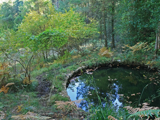
We arrive at this legendary place of the Andalusian flora. Here, under the pines, the density of holly trees is maximum, and the size of its specimens, surprising. The atmosphere is dark and we feel totally enveloped by an atmosphere typical of a forest in central or northern Europe. It is a place to stop, observe and feel. After passing the Barranco, a little more light enters, and therefore the diversity of species is greater. The cleaning of this short section of the Bosques del Sur trail has been shallow to respect the ecological value of the environment as much as possible, so that on the way there are ferns and branches of hazelnut trees, holly trees, hawthorn trees and rose bushes that can disturb. Until we reach the forest house of Las Acebeas, we walk along a special section where it is convenient to go slowly enjoying all the details of its flora calmly. We will pass by a small round pond, which was where the water accumulated to irrigate the garden of the family of the forest guard, when he lived permanently in the forest house to which we are going to arrive shortly.
Las Acebeas Forest House
This point is a strategic crossroads at this stage. The Las Acebeas forest house is still in use, and the fence that surrounds it is usually closed. It is a large and beautiful house, with several holly trees and a yew tree planted on its doorstep. At present it is planned to be used as the headquarters of an observatory for monitoring climate change through the analysis of the evolution of the natural park vegetation. The place could not be more suitable, since we are in a forest whose particularity derives precisely from the relationship between vegetation and climate change. When this was of exclusively natural origin, the vegetation of northern Europe took refuge in these places during the last ice age, and then a good part of it remained here despite the softening of the climatic conditions of the current postglacial period.
At this point we can choose to go up to Navalperal, on the left, along the signposted path PR-A 176, which is part of the Bosques del Sur path as derivation 10 and whose descriptio ...
Las Acebeas Forest House
This point is a strategic crossroads at this stage. The Las Acebeas forest house is still in use, and the fence that surrounds it is usually closed. It is a large and beautiful house, with several holly trees and a yew tree planted on its doorstep. At present it is planned to be used as the headquarters of an observatory for monitoring climate change through the analysis of the evolution of the natural park vegetation. The place could not be more suitable, since we are in a forest whose particularity derives precisely from the relationship between vegetation and climate change. When this was of exclusively natural origin, the vegetation of northern Europe took refuge in these places during the last ice age, and then a good part of it remained here despite the softening of the climatic conditions of the current postglacial period.
At this point we can choose to go up to Navalperal, on the left, along the signposted path PR-A 176, which is part of the Bosques del Sur path as derivation 10 and whose description can be found in this same guide. It is a route with fantastic views and it may be worth including it in our journey, since stage 21 is moderate in length.
But what is inexcusable is to take a round trip along the forest track that we find on our right. It is the one that joins the forest house with the road, and it is also the first section of the aforementioned PR-A 176. It is a wide path of about 600 meters, almost without unevenness, with an extraordinary leafiness and where we can enjoy the exceptional presence of hazelnuts. It is the southernmost hazelnut in Europe, accompanied by many other northern species.
To continue our stage, we pass behind the forest house. We continue to see holly trees, especially to our right. It is necessary to know that this section gets flooded in some places, but no intervention has been made to avoid it due to the ecological fragility of the area.
Crossing with forest track
We come to a wide forest track that, except for its first meters, has very little unevenness. Here we leave the reserve area and walk through a good black or salgareño pine forest.
Snow Well
We arrive at a source of permanent flow and, a few meters from it, we see the Pozo de la Nieve, a robust and hidden stone construction where snow was formerly stored, which was converted into ice in an artisanal way for transport and use during summer on the part of those who could afford that luxury. The well where the snow was stored and pressed is currently bricked up for security reasons, so there is only a small room inside the building as a small shelter. Some 150 meters further on, we leave the track and continue straight ahead along a path that will soon become a beautiful traditional path. From now on, our GR coincides with several short-distance trails (PR), so many of the beacons on the Bosques del Sur trail are colored white, red, and yellow.
This area is sunnier, so the vegetation becomes more thermophilic. Holm oak abounds and rockrose appears, while black pine is mixed with stands of black pine, with reddish bark. On our right, below, we will see the hidden village of La Fresnedilla, and little by little gr ...
Snow Well
We arrive at a source of permanent flow and, a few meters from it, we see the Pozo de la Nieve, a robust and hidden stone construction where snow was formerly stored, which was converted into ice in an artisanal way for transport and use during summer on the part of those who could afford that luxury. The well where the snow was stored and pressed is currently bricked up for security reasons, so there is only a small room inside the building as a small shelter. Some 150 meters further on, we leave the track and continue straight ahead along a path that will soon become a beautiful traditional path. From now on, our GR coincides with several short-distance trails (PR), so many of the beacons on the Bosques del Sur trail are colored white, red, and yellow.
This area is sunnier, so the vegetation becomes more thermophilic. Holm oak abounds and rockrose appears, while black pine is mixed with stands of black pine, with reddish bark. On our right, below, we will see the hidden village of La Fresnedilla, and little by little great views open to the east, where mountains such as Los Calarejos and Puntal de Rayuela (also called La Ajedrea and Siles) appear. Further to the northeast, we can see the elevations of our great mountain range in the province of Albacete, such as La Sarga, El Padroncillo, La Almenara and Calar del Mundo, some of them in the neighboring Los Calares del Mundo Natural Park and of La Sima. We will also cross a forest track that, on the right, would take us to the nearby La Canalica campsite.
Path to the Stone of Holes
At this point, a tiny unmarked path starts to the left, with a fairly steep slope that would lead us to the area of Piedra de los Agujeros, a curious geomorphological landmark at an altitude of 1304 meters that is an example of ruiniform relief in dolomites. If we decide to climb, we will contemplate beautiful views in all directions. Following our route, later on, if we turn our eyes backwards we can see the Stone, of which only one hole is usually seen, but from certain angles it can be seen that it has a second long and very narrow opening, hence its name. From our path we continue enjoying good views to the east, in addition to the pleasure of traveling an old road with dry stone chocks, which makes our imagination fly to a past in which building these communication routes cost an enormous effort. In front is the unmistakable Muela de Bucentaina.
Collado de Mirahueta
The path leads to a somewhat wider path. A few meters before, on our left, it is convenient to deviate a few steps to a magnificent natural viewpoint towards the opposite slope. We are in the Collado de Mirahueta, where we pass from Mount Navalperal to Mount Bucentaina, and from the aforementioned viewpoint we are surprised by a vast panoramic view to the west, with large forests, the small village of La Hueta, the Peñalta and El Yelmo mountains, Sierra Oruña and, in the distance, the Sierras de Las Villas and Cazorla.
Following our route, we soon understand why Bucentaina is one of the mountains with the best Mediterranean vegetation in the natural park. Under the black pine forest grows a powerful undergrowth of holm oaks, junipers, olive trees (Phyllirea angustifolia) and some strawberry trees and cornicabras. The latter provide a beautiful chromatic brushstroke in autumn. In front we see the mountains of Albacete mentioned above and the small town of Cotillas.
North face of Bucentaina
Our route leads to a forest track that surrounds the entire Bucentaina. We walk along it for a few meters to reach a small clear plain, through which a firebreak passes and from which there are magnificent views. Here we turn left along a small path and change slope. The path immediately begins to descend vertiginously, entering the north face of the Bucentaina. If there was a good undergrowth on the east face, where we come from, the north face has spectacular vegetation that completely envelops us. The atmosphere becomes more shady and a tight coverage of noble species appears, among which the strawberry tree and the durillo (Viburnum tinus) stand out. At kilometer 10.2 we come to a forest track again, which we immediately abandon to continue along our extraordinary path. From time to time the views open towards the town of Siles, the Guadalimar valley and the Sierra del Calderón.
Crossing with forest track
We come to a new forest track and turn right, going over the last section of stage 21, which for 1.4 km coincides with the first section of stage 1, which has been climbing in the opposite direction from the Peña del Olivar Recreational Area . Going along this forest track, to our left we already contemplate a pleasant and humanized landscape, with a rural environment, with olive groves, small orchards watered by the Los Molinos stream and the nearby town of Siles. In the distance, the naked and unmistakable Piedra del Cambrón, and to its right the mountains of Albacete that we mentioned earlier. At kilometer 11.5 we find the El Noguerón spring, with a lot of flow, where the Sileños frequently go to stock up on quality water.
Peña del Olivar Recreational Area
One kilometer below the El Noguerón fountain, we finish the stage at the Peña del Olivar Recreational Area, a very popular place for the residents of Siles. It is located on both sides of the Arroyo de Los Molinos and has a fountain, bar, terrace, tables, children's playground and, in summer, a magnificent natural bathing area with cold and clean waters. There is also a small park with a botanical collection in which you can see many of the most representative species of the flora of the natural park.
Additional information
Acebeas-Nava del Espino Reserve
Barranco de los Acebos Part of this Stage runs through the Acebeas-Nava del Espino Reserve Area. The Reserve Areas are the areas with the highest level of protection within the Natural Park due to their high ecological value. The reason that these two mountains are specially protected is that they are home to a high concentration of species of extraordinary ecological relevance, either because they are endemic, because they are in danger of extinction or because they are northern species whose presence in southern Spain is exceptional.
Specifically, in the Area there are no less than 141 species classified as rare, endemic and threatened, 22 of which are protected by law. Among them are the Cazorla violet (Viola cazorlensis) and a narcissus (Narcissus longispathus). The world distribution of this last species is almost exclusively limited to the Natural Park.
Las Acebeas, a northern islet in the south
Discovering a forest like Las Acebeas in the south is a luxury. These ...
Acebeas-Nava del Espino Reserve
Barranco de los Acebos Part of this Stage runs through the Acebeas-Nava del Espino Reserve Area. The Reserve Areas are the areas with the highest level of protection within the Natural Park due to their high ecological value. The reason that these two mountains are specially protected is that they are home to a high concentration of species of extraordinary ecological relevance, either because they are endemic, because they are in danger of extinction or because they are northern species whose presence in southern Spain is exceptional.
Specifically, in the Area there are no less than 141 species classified as rare, endemic and threatened, 22 of which are protected by law. Among them are the Cazorla violet (Viola cazorlensis) and a narcissus (Narcissus longispathus). The world distribution of this last species is almost exclusively limited to the Natural Park.
Las Acebeas, a northern islet in the south
Discovering a forest like Las Acebeas in the south is a luxury. These forests extend through the center and north of the Peninsula, and the ones we have here are a vegetable jewel. They arrived here thousands of years ago, pushed south by the cold and ice of the last ice age. When these retired, the holly trees began a migration in the opposite direction, reconquering the lost territory to the north, with which we can affirm that the current holly trees of Europe are descendants of ours. This forest is still here thanks to a fortunate coincidence of suitable soils and opportune microclimate.
Bucentaina, Mediterranean forest in its purest form
This Stage could well be described as the route of the two forests. The first of them, Las Acebeas, is renowned for its exceptional nature. The second does not have it, because it is a relatively abundant plant formation, although not in many places it is as well preserved as here. It is the forest of Mount Bucentaina, especially its north face.

Follow us #JaénParaísoInterior


