


Refugio Campo del Espino - Pontones

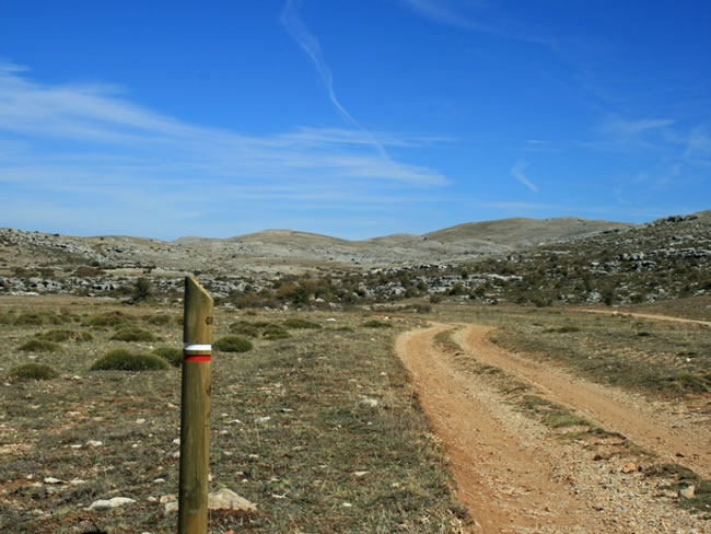
This is one of the stages that go through the breathtaking plateau of Los Campos de Hernán Perea, at an average altitude of 1600 m, a vast territory that has historically been deforested to open pastures to the Segureño sheep. Its landscape is impressive due to the breadth of its panoramic views, always flanked by high elevations, such as Calar de las Palomas on the right and Pinar del Risco on the left. In winter it is the territory of snow. In spring, from the green high pastures. And always, the home of an ancient cattle culture that deserves the highest recognition. The griffon vulture and the kestrel will accompany us with their flight.
In the section that runs through Los Campos there are hardly any trees, but in exchange for this lack we enjoy wide horizons and a deep feeling of being in one of the most remote, authentic and unknown enclaves of the Andalusian mountains. In reality, the feeling of loneliness is still somewhat deceptive, since being a very livestock area, it is common to find shepherds who are taking care of their Segureño sheep.
We will visit one of the encl ...
This is one of the stages that go through the breathtaking plateau of Los Campos de Hernán Perea, at an average altitude of 1600 m, a vast territory that has historically been deforested to open pastures to the Segureño sheep. Its landscape is impressive due to the breadth of its panoramic views, always flanked by high elevations, such as Calar de las Palomas on the right and Pinar del Risco on the left. In winter it is the territory of snow. In spring, from the green high pastures. And always, the home of an ancient cattle culture that deserves the highest recognition. The griffon vulture and the kestrel will accompany us with their flight.
In the section that runs through Los Campos there are hardly any trees, but in exchange for this lack we enjoy wide horizons and a deep feeling of being in one of the most remote, authentic and unknown enclaves of the Andalusian mountains. In reality, the feeling of loneliness is still somewhat deceptive, since being a very livestock area, it is common to find shepherds who are taking care of their Segureño sheep.
We will visit one of the enclaves that give greater identity to the natural park: the source of the Segura river, which flows in a spectacular crystalline pool. The water arises from a cave that is part of the underground system that collects the abundant rainfall that falls in the Campos de Hernán Perea. In their surroundings, the cave paintings of the Shelter of La Cañada de la Cruz bear witness that human beings felt these mountains as welcoming thousands of years ago.
This stage begins at the start of the GR 247.2 variant. Near the source of the Segura river, derivation 6 of the GR 247 begins, towards the Juan León viewpoint, which in a short walk looks out from the Segura valley to the Guadalquivir valley.
Technical information
Route Name Rutas Bosques GR247
Rutas Bosques GR247 17: Refugio Campo del Espino - PontonesHUSO 30S
Refugio Campo del Espino: x524433 y4209653
Pontones: x528887 y4218979
Refugio Campo del Espino: x524321 y4209445
Pontones: x528775 y4218771
TOTAL DISTANCE (IN KILOMETERS)14150
Asphalt or cement section 6,86 %
Section of track or forest road or promenade 88,89 %
Senda section 4,25 %
tramos-de-Vía-pecuaria 88,89 %
ESTIMATED RUN TIMEO
4 hMAXIMUM SLOPE366 m
DIFFICULTY. ASSESSMENT ACCORDING TO METHOD MEASURE
2
MEDIO.
Severity of the natural environment
2
Itinerary
Orientation in the itinerary
2
Displacement
Difficulty moving
3
EFFORT.
Amount of effort required
TOTAL DISTANCE (IN KILOMETERS) 19540 M
Start
By forest track from the village of Don Domingo and from the Nacimiento del Segura.
Final
A Pontones is accessed by the A-317 road.
INTERMEDIATE POINTS
PLACE
POSITION
TYPE OF ROAD
5,1
Pista forestal
9,6
Carretera
CYCLABILITY
There are no special difficulties, except at some point in the surroundings of Fuente Segura.
WATER POINTS
Campo del Espino Refuge (cistern), Pozo Turmas, Las Palomas fountain, Nacimiento del Segura, Pontones.
PREFRESHING POINTS
On the trail: Pontones
Near the trail: No
LINKS WITH OTHER TRAILS
GR 7, GR 144
Rutómetro
Campo del Espino Refuge
We left the Campo del Espino refuge, in the middle of the overwhelming solitude of the Los Campos de Hernán Perea plateau. Around us a very open and treeless landscape, with wide views, dominated by large grasslands, undulating mounds, very fragmented rocks and, probably, a herd of Segura sheep observed from the sky by the griffon vulture. Attention to the winter snowfalls, which are frequent and do not do anything advisable to venture into a territory where the roads are erased and with few indicative references for those who do not know them well. We start walking along the forest track, well marked. There are no trees around us, except those that we see in the distance covering the slopes of Pinar del Risco, which will close the landscape on our left for several kilometers. Beyond these elevations, the terrain drops vertiginously towards the Guadalquivir valley, today covered by the El Tranco reservoir. After a little more than 1 kilometer, on the left we see the Cortijo de Serafín, one of the few in the area.
Turmas Well
To our right we see the well and the wells of Pozo Turmas. It does not always have water, because given the elevation and the low slope of the terrain, the waters that arise throughout this environment are very shallow, that is, they are shallow and not always enough water accumulates to allow it to flow continuously. Tilled plots also appear in the middle of the pastures, sometimes in small depressions with deeper soil where the terrain is conducive to agricultural use. They are dedicated to the cultivation of rainfed cereals, usually oats or rye, and sometimes delicious chickpeas. The landscape begins to become more hilly.
Tinada and Las Palomas Fountain
We pass by the beautiful Las Palomas tinada, used for livestock purposes, and a little further on we come to the source of the same name, next to a small poplar grove that is like an oasis in this treeless landscape. The name of Las Palomas is due to the fact that it is the calar that we have to the right, whose summit, which is close to 2000 meters of altitude, is one of the highest in the natural park. We continue to enjoy a certain Finisterre atmosphere, of being in a place at the end of the world, lost, elevated, lonely and moving.
Cañada de la Cruz
There are not many places of reference in the uniform and vast landscape of the Campos de Hernán Perea, but this is one of them. It is a long and embedded strip of flat and fertile land, where cereals are grown and several important roads intersect, such as the GR 144, called Ruta de la Trashumancia, which comes from the village of Don Domingo, and with which it coincides during a section of the Bosques del Sur trail. In generous rainy years, much of the Cañada de la Cruz becomes a temporary lagoon during winter and spring. This circumstance, in addition to providing an unexpected element of landscape diversity, has served for scientists to carry out a palynological study using pollen from sediments deposited in the lagoon, as a result of which a surprising film of the evolution of the vegetal landscape of these mountains over the past eight millennia, and which we comment on in the attached highlighted box.
From here the landscape changes. If, at the beginning of stage 16, starting from Rambla Seca, the Bosques d ...
Cañada de la Cruz
There are not many places of reference in the uniform and vast landscape of the Campos de Hernán Perea, but this is one of them. It is a long and embedded strip of flat and fertile land, where cereals are grown and several important roads intersect, such as the GR 144, called Ruta de la Trashumancia, which comes from the village of Don Domingo, and with which it coincides during a section of the Bosques del Sur trail. In generous rainy years, much of the Cañada de la Cruz becomes a temporary lagoon during winter and spring. This circumstance, in addition to providing an unexpected element of landscape diversity, has served for scientists to carry out a palynological study using pollen from sediments deposited in the lagoon, as a result of which a surprising film of the evolution of the vegetal landscape of these mountains over the past eight millennia, and which we comment on in the attached highlighted box.
From here the landscape changes. If, at the beginning of stage 16, starting from Rambla Seca, the Bosques del Sur trail stopped honoring its name and entered that beautiful treeless exception that are the Campos de Hernán Perea - named by the local population Los Campos, to dry - the last section of stage 17 recovers normality in the landscape, sheltering the walker again under the pine forest of Salgareño. A pine forest, it must be said, that is not very impressive, since it is repopulated, but in which some great specimens stand out that for some reason never succumbed to the ax.
On our right we have Mount Mariasnal, and on the left the Andalusian Hunting Reserve, which is a direct heir to the legendary Cazorla-Segura National Hunting Reserve, created in 1960 to promote larger game hunting and which turned life upside down in the region, since, while the mountain was repopulated with deer and wild boar to favor hunting larger game, it was depopulated of humans forced to abandon their old farmhouses by hook or by crook. Cruel paradoxes of times, fortunately, past, but that have left a deep social mark.
Further on, at km 8.7, we will find the crossroads, but well signposted, that leads us to the Mirador de Juan León, a place of superb panoramic views from where we can see, precisely, some of the abandoned villages in those bitter years, like Los Centenares and Los Miravetes. This natural viewpoint can also be reached from the source of the Segura by derivation 6 of the Bosques del Sur trail.
Birth of Segura
The Bosques del Sur trail reaches at this point one of the enclaves with the greatest symbolic identity of the natural park: the source of the Segura river, which takes its name from that of the Sierra and region in which it is located (and not the other way around, as sometimes it is said). In a spectacular crystalline pool of about 7 meters in diameter by 6 meters deep, whose state is highly variable depending on the weather of the year. The water flows through the mouth of a cave that is part of the underground system that collects the abundant rainfall of water and snow that falls on the nearby plateau of Campos de Hernán Perea, which are a real sponge.
But the whole environment of the birth has, in addition, a singular importance for the knowledge of the prehistory of these mountains, inhabited since very remote times. For example, in the Shelter of La Cañada de la Cruz, which can be seen some 300 m before reaching the source, up to our right as we come from the south, it houses cave paintings that represent a ...
Birth of Segura
The Bosques del Sur trail reaches at this point one of the enclaves with the greatest symbolic identity of the natural park: the source of the Segura river, which takes its name from that of the Sierra and region in which it is located (and not the other way around, as sometimes it is said). In a spectacular crystalline pool of about 7 meters in diameter by 6 meters deep, whose state is highly variable depending on the weather of the year. The water flows through the mouth of a cave that is part of the underground system that collects the abundant rainfall of water and snow that falls on the nearby plateau of Campos de Hernán Perea, which are a real sponge.
But the whole environment of the birth has, in addition, a singular importance for the knowledge of the prehistory of these mountains, inhabited since very remote times. For example, in the Shelter of La Cañada de la Cruz, which can be seen some 300 m before reaching the source, up to our right as we come from the south, it houses cave paintings that represent a female figure and scenes of hunting with a bow. They are considered to belong to the middle or final moments of the development of Levantine art. Further on, also on the right side as we arrive on our route, almost over the pool where the Segura river sees the light, is the Birth Cave. It is a shallow cavity but with an opening of more than 20 m, which is currently used as a swamp (corral for cattle). The human presence in the cave is dated from the Upper Paleolithic, around 9250 BC, to the Final Neolithic, around 2040 BC. Archaeological investigations have shown that, in prehistoric times, not only deer, wild boar and mountain goats were hunted, but also species already extinct in the area, such as roe deer and chamois. On the other hand, studies of the pollen deposited in the cave during thousands of years show that in the Middle Neolithic phases, certain deciduous trees, such as birch, hazel and elm, were much more abundant than today, with the presence of the beech, today extinct. Fauna and flora that tell us, therefore, of a more humid and colder climate than the current one.
The route passes through the village of Fuente Segura and continues along a traditional path with a brief exit to the road. It runs flanked to the left by a long oblique ballast (smooth stone), and to the right by the very first of the many meadows that the Segura River has to irrigate on its long way to the Mediterranean. This is a family valley, almost intimate, to which the Segura offers its cleanest waters. Some of their gardens are already abandoned, but until a few decades ago they played a vital role in the subsistence economy of these villages. Today some are still alive and fully productive apple, pear and walnut trees abound.
Pontoons
The stage ends in Pontones, or, to be more exact, in Pontón Bajo, as higher up is also Pontón Alto. Pontones is a small town closely linked to the Segura River. In both pontoons the traveler will find accommodation to eat and sleep. Sleeping, by the way, in bed, which you will be infinitely grateful if you come from traveling the long stages that come from Cazorla, in most of which you will have had to spend the night in Spartan mountain shelters.
To leave Pontones and start stage 18, just go through the town to the A-317 road. At the exit from Pontones to Santiago de la Espada we will find a small viewpoint with a wooden fence and a white hut, where the information panel for the start of the next stage is located.
Additional information
The Mediterranean side of the Natural Park
Two of the most important rivers in southern Spain are born in the natural park: the Guadalquivir and the Segura, which flow into the Atlantic and the Mediterranean respectively. The Sierras de Cazorla, Segura and Las Villas receive significant rainfall in the form of water and snow, being one of the most important pluviometric islets in southern Spain, in contrast to the limited rainfall in the southern and eastern areas of the natural park, which connect with the provinces of Granada, Almería and Murcia. This great mountain massif is, therefore, an enormous reservoir of water, both superficial and underground, and also forms a watershed between the Atlantic and Mediterranean basins. Most of the park belongs to the first, but part of the northern area, in the Sierra de Segura, where this stage runs, corresponds to the second.
The source of the Segura, in the beautiful pool of Fuente Segura, is precisely at this stage of the GR 247 Bosques del Sur trail. Later, the river runs deeply embedd ...
The Mediterranean side of the Natural Park
Two of the most important rivers in southern Spain are born in the natural park: the Guadalquivir and the Segura, which flow into the Atlantic and the Mediterranean respectively. The Sierras de Cazorla, Segura and Las Villas receive significant rainfall in the form of water and snow, being one of the most important pluviometric islets in southern Spain, in contrast to the limited rainfall in the southern and eastern areas of the natural park, which connect with the provinces of Granada, Almería and Murcia. This great mountain massif is, therefore, an enormous reservoir of water, both superficial and underground, and also forms a watershed between the Atlantic and Mediterranean basins. Most of the park belongs to the first, but part of the northern area, in the Sierra de Segura, where this stage runs, corresponds to the second.
The source of the Segura, in the beautiful pool of Fuente Segura, is precisely at this stage of the GR 247 Bosques del Sur trail. Later, the river runs deeply embedded in the Santiago-Pontones area, where it is dammed in the small Anchuricas reservoir. It receives on its left bank the waters of the Madera River, which runs through large pine forests, and on the right those of the Zumeta, which marks the limit with Albacete until it joins the Segura in Las Juntas de Miller, which at that point leaves the natural park . Another of the Segura tributaries in the park is the Tus, which originates in the municipality of Siles and joins the Segura in Albacete lands. These four rivers and other minor tributaries run through areas of great beauty and ecological relevance.

Follow us #JaénParaísoInterior


