


Refugio CF Fuente Acero - Refugio Rambla Seca

This short stage in the southeastern part of the park runs through areas of great ecological relevance, as in fact it always has the Navahondona-Guadahornillos Reserve Area on its left. It runs at a remarkable altitude, specifically between 1500 and almost 1600 meters, always going along a forest track with very little unevenness.
The territories through which we will walk are fully part of the extensive kingdom of the black or salgareño pine, of which we will see notable specimens here. Among them, the so-called Pino Félix Rodríguez de la Fuente stands out, named after the unforgettable promoter of nature who in the 70s of the last century chose these places to record some of his most famous nature documentaries.
The route always has to the right the great elevations of the Sierra de La Cabrilla, a massif that groups the largest concentration of two thousand in the natural park. Among them, the Alto de La Cabrilla, the Pico de Las Covachas, the Cerro de Los Tornajos and the Empanadas, which at 2107 meters is the highest peak in the park. Even, on clear days, we can see Sierra Nev ...
This short stage in the southeastern part of the park runs through areas of great ecological relevance, as in fact it always has the Navahondona-Guadahornillos Reserve Area on its left. It runs at a remarkable altitude, specifically between 1500 and almost 1600 meters, always going along a forest track with very little unevenness.
The territories through which we will walk are fully part of the extensive kingdom of the black or salgareño pine, of which we will see notable specimens here. Among them, the so-called Pino Félix Rodríguez de la Fuente stands out, named after the unforgettable promoter of nature who in the 70s of the last century chose these places to record some of his most famous nature documentaries.
The route always has to the right the great elevations of the Sierra de La Cabrilla, a massif that groups the largest concentration of two thousand in the natural park. Among them, the Alto de La Cabrilla, the Pico de Las Covachas, the Cerro de Los Tornajos and the Empanadas, which at 2107 meters is the highest peak in the park. Even, on clear days, we can see Sierra Nevada. The path also allows us to see the spectacular Guadalentín valley in some sections.
A detour of 4.5 kilometers offers the opportunity to know one of the most beautiful places in the park, the Laguna de Valdeazores, an option to take into account given the short length of the stage.
The fauna is one of the great attractions of this stage, because if we are attentive it is very common to see wild boars, fallow deer, mouflon, deer or mountain goats. The stage ends at Rambla Seca, where we will be surprised by a radical change of landscape: the world of trees gives way to that of pastures, and before our eyes vast panoramas, treeless and rough, but of an exciting beauty begin from the Campos de Hernán Perea.
Technical information
Route Name Rutas Bosques GR247
Rutas Bosques GR247 15: Refugio CF Fuente Acero - Refugio Rambla SecaHUSO 30S
Refugio C.F. Fuente Acero: x513170 y4194859
Refugio Rambla Seca: x518877 y4200118
Refugio C.F. Fuente Acero: x513059 y4194651
Refugio Rambla Seca: x518766 y4199910
TOTAL DISTANCE (IN KILOMETERS)11420
Asphalt or cement section 0 %
Section of track or forest road or promenade 100 %
Senda section 0 %
tramos-de-Vía-pecuaria 0 %
ESTIMATED RUN TIMEO
2 h 50 minMAXIMUM SLOPE168 m
DIFFICULTY. ASSESSMENT ACCORDING TO METHOD MEASURE
2
MEDIO.
Severity of the natural environment
2
Itinerary
Orientation in the itinerary
1
Displacement
Difficulty moving
2
EFFORT.
Amount of effort required
TOTAL DISTANCE (IN KILOMETERS) 19540 M
Start
The Fuente Acero Forest House Refuge is accessed from the Empalme del Valle, on the A-319 road. From there, take the JF-7091 road and the track that continues to Nava de San Pedro.
Final
The Rambla Seca Refuge is accessed from the village of Don Domingo, on the J-9005 road that arrives from the vicinity of Santiago de la Espada. From Don Domingo, continue along the Campos de Hernán Perea forest track.
CYCLABILITY
He has no difficulties.
WATER POINTS
Fuente del Acero Forest House Refuge, Nava de Paulo Forest House (in the vicinity of the Trail), Rambla Seca Refuge (source-watering hole 150 meters away).
PREFRESHING POINTS
On the trail: There is no
Near the trail: No
LINKS WITH OTHER TRAILS
GR 144
Rutómetro
Fuente Acero Forest House Refuge
The Fuente Acero forest house is on the JF-7091 forest track, very close to Caballo Acero and 6.4 km from Nava de San Pedro. It is the arrival or departure point of three stages of the Bosques del Sur trail. On the one hand, one of the stages of the GR 247.3 variant, whose starting point we will find 300 m further on, would take us to the shelter of the Sacejo forest house near the El Adelantado de Cazorla Parador de Turismo; on the other, stage 14 of the trail, which would take us to the El Hornico Nature Room, near the La Bolera and Pozo Alcón reservoirs; and finally the stage that we describe below, whose route takes place entirely along the main forest track, initially in a northeast direction, towards Collado Bermejo and Campos de Hernán Perea.
Crossing with a track towards the Guadalentín Valley
As soon as we start the stage, we find to the right a forest track –with a barrier to prevent the passage of vehicles– through which we could cross the Guadalentín river valley until it reaches the La Bolera reservoir, and which corresponds, as we have mentioned in previous point, with stage 14 of the trail. Our route continues straight ahead, always along an open forest track and taking the limit of the Navahondona-Guadahornillos Reserve Area to our left. We will see the limit of this reserve marked with signs that indicate that its degree of protection is "A", which is the maximum in the natural park due to its high ecological values.
On our right is the Sierra de la Cabrilla, which impresses with its altitude despite being at 1500 m altitude. In the background, in La Cabrilla, the Empanadas peak appears, which with its 2107m is the roof of the natural park.
Collado Bermejo
To our left there is a slightly uphill track, which has another barrier for vehicles at its highest point. It is Collado Bermejo, the starting point of one of the most popular hiking routes in the natural park, which reaches the Laguna de Valdeazores and can be continued along the famous Borosa route. It is very common to find vehicles parked at this point. The route to the lagoon has a distance of 4.5 km and is part of the network of ornithological routes existing in the park. Since the length of stage 15 is not very long (11.4 km), it is highly recommended to do this route to later return to this point and continue our way along the Bosques del Sur trail.
Continuing along the main track, the path turns momentarily to the east, opening up the panoramic view over the Guadalentín valley even more. On clear days, in the distance we can see the Sierra Nevada massif.
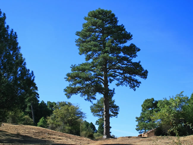
Pino Félix Rodríguez de la Fuente
The slight ascent that we have taken from the beginning ends, reaching Collado de la Zarca, which is very easy to identify, because right at this point we find one of the most emblematic black or salgareño pines in the park, the Pino Félix Rodríguez. de la Fuente, of extraordinary dimensions, 4.5 meters in perimeter and 24 meters high, included in the Catalog of Singular Trees and Groves of Andalusia. His name is a tribute to the great communicator and disseminator of nature who in the 70s of last century recorded some of the chapters of the popular television documentary series Man and the Earth in these places.
At this point it is advisable to take two short walks. On the left we can follow a track closed to vehicles, to reach the ruins of the Nava de Paulo forest house in just over 600 meters, where there is a fountain with a trough for animals. It is an area conducive to wildlife observation, so it is advisable to be attentive and silent, being very common to see wild boars, fallow deer, mouflo ...
Pino Félix Rodríguez de la Fuente
The slight ascent that we have taken from the beginning ends, reaching Collado de la Zarca, which is very easy to identify, because right at this point we find one of the most emblematic black or salgareño pines in the park, the Pino Félix Rodríguez. de la Fuente, of extraordinary dimensions, 4.5 meters in perimeter and 24 meters high, included in the Catalog of Singular Trees and Groves of Andalusia. His name is a tribute to the great communicator and disseminator of nature who in the 70s of last century recorded some of the chapters of the popular television documentary series Man and the Earth in these places.
At this point it is advisable to take two short walks. On the left we can follow a track closed to vehicles, to reach the ruins of the Nava de Paulo forest house in just over 600 meters, where there is a fountain with a trough for animals. It is an area conducive to wildlife observation, so it is advisable to be attentive and silent, being very common to see wild boars, fallow deer, mouflon, deer or mountain goats. If at Collado de la Zarca we go to the right, cresting, we arrive at the so-called Collado del Rainmetro. It is, without a doubt, the place with the best panoramic view of the entire route. The rain gauge is metallic and is installed on a rocky area at an altitude of 1,692 meters, being visible from many points in this area due to its large size.
Continuing our journey along the main track, from kilometer 8 we cross the Cañada Pajarera, on our right, which will finally take us to Nava Noguera. The navas are very fertile lands at a certain altitude, where, if they have not been cultivated, there may be traces of more northern vegetation, remains of the last ice age. In this area, the gigantic size of the hundred-year-old black pines that are to the right of the track is striking, from which it is worth leaving to contemplate them closer.
The flat road from Collado de la Zarca. Soon large clearings begin to open, a preamble to what we will find later. At kilometer 10.5 we pass some wooden tornajos (cattle trough) on our left, at the foot of a cherry tree (Prunus mahaleb), a deciduous tree that is precisely one of the representatives of that peculiar flora of the nava.
Dry Rambla
We arrive at the Rambla Seca Control, a small building next to a door through which we must pass, always taking the precaution of closing it again to avoid the transit of animals. From here, access to the Andalusian Hunting Reserve of Cazorla-Segura, formerly National Reserve, is controlled. The barrier is closed to vehicles from 9:00 p.m. to 9:00 a.m.
Passing the door produces a shocking change in the landscape. The arboreal vegetation disappears and only a few arros thorns (Berberis hispanica) accompany us on our way. We are at the beginning of the Campos de Hernán Perea, undoubtedly the best pastures in the park, fresh pastures raised at 1600 meters of altitude, which is the average height of the plains that open in front of us. This is also where another of the park's Long Distance trails begins, the Sendero de la Trashumancia (GR 144), which runs along the livestock tracks through which the flocks of Segureña sheep go down to warmer areas to spend the autumn and winter to return to these cool areas in spring and summer.
Rambla Seca Refuge
We reach the end of the stage, located in the Rambla Seca shepherd's refuge. This refuge, like others in the Campos de Hernán Perea, is a very unique construction, basically composed of a room with a door, windows and a cistern that collects rainwater, with a manual pump for its extraction. Remember that it is water without any sanitary treatment. They are infrastructures traditionally used by the shepherds who have their herds here. With them we can share some other endearing evening. It is especially important to be respectful in the use of these shelters, whose maintenance and good condition is essential for shepherds in an area as isolated as this one.
Additional information
The extinct fauna
There are several species of fauna that, over the last centuries, have become extinct in the territories that today make up the natural park. The toponymy of these mountains evokes the presence of the bear (Ursus arctos) until the middle of the 17th century, with names such as La Osera, La Fuente del Oso or La Dehesa del Oso. In the Book of Hunting, ordered to be written by King Alfonso XI around the years 1340 and 1350, there is talk of the abundance of bears in certain mountains of the park, as well as in the relations of the peoples of Spain ordered by Felipe II in the year 1575.
Other extinct species in the Sierras de Cazorla, Segura and Las Villas are the wolf (first quarter of the 20th century), the roe deer (mid-20th century) and the Iberian lynx (last decades of the 20th century). Fortunately, this is not all bad news: the bearded vulture, after disappearing during the 1980s, once again flies over the park thanks to an ambitious reintroduction project launched by the Gypaetus Foundation. Will these Sierras be the home of any of the species that always lived in them?

Follow us #JaénParaísoInterior


