


Belerda - Aula de Naturaleza El Hornico

This is the stage of the Bosques del Sur trail that takes place in the southernmost part of the natural park, specifically in the Sierra del Pozo. We will walk through the mountains in which the last guerrillas who resisted in the province of Jaén took refuge against the dictatorship after the Civil War of 1936-39. These roads, which lead the Ruta de los Maquis de Quesada, are the same ones they used until 1952, the year in which the guerrilla Manuel Calderón Jiménez, "El Ramiro", died at the hands of the Civil Guard, and the last group was dissolved. of the Jaen resistance.
The route runs through a natural balcony between opposite worlds. On one side we will have the depression of the Guadiana Menor, one of the most important tributaries of the Guadalquivir with 152 kilometers in length, which runs through the provinces of Jaén and Granada. This depression constitutes a sub-desert area, with little rainfall and an accelerated natural erosion process that forms rough and highly degraded landscapes that are called badlands. On the other side of this great plain, two massifs with their own ...
This is the stage of the Bosques del Sur trail that takes place in the southernmost part of the natural park, specifically in the Sierra del Pozo. We will walk through the mountains in which the last guerrillas who resisted in the province of Jaén took refuge against the dictatorship after the Civil War of 1936-39. These roads, which lead the Ruta de los Maquis de Quesada, are the same ones they used until 1952, the year in which the guerrilla Manuel Calderón Jiménez, "El Ramiro", died at the hands of the Civil Guard, and the last group was dissolved. of the Jaen resistance.
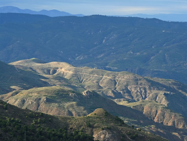
The route runs through a natural balcony between opposite worlds. On one side we will have the depression of the Guadiana Menor, one of the most important tributaries of the Guadalquivir with 152 kilometers in length, which runs through the provinces of Jaén and Granada. This depression constitutes a sub-desert area, with little rainfall and an accelerated natural erosion process that forms rough and highly degraded landscapes that are called badlands. On the other side of this great plain, two massifs with their own names are easily recognizable: in the foreground, to the west, the Sierra Mágina massif, another of the natural parks of the subbetic mountain ranges of Jaén; and in the background, much farther and to the south, we contemplate the Sierra Nevada massif.
The gorges and ravines of the mountain ranges through which we walk collapse towards the arid plain, being rugged mountains, with peaks over 2000 meters of altitude, where the gray and ocher of the rock are combined with the different green tones of a abundant vegetation.
The itinerary is a continuous ascent until reaching an altitude of 1,595 meters, near Puntal del Gato, descending from there to the Llanos de la Puerca, very close to the El Hornico nature classroom. In addition to vultures and other raptors, it is quite common to observe thrushes and small insectivorous birds, being also a propitious terrain to surprise mountain goats, mouflon, fallow deer and wild boars on our walk.
For Poceños, which is how the natives of Pozo Alcón are called, the La Bolera reservoir is emblematic, with its 55 cubic hectometres of capacity and 240 hectares of surface. It forms a landscape with northern airs in the south, having very attractive places, such as recreational areas –among which Hoyo de los Pinos stands out–, the dam, the pier and its bathing areas. In El Hornico it is essential to visit its Botanical Collection, a garden where a good part of the great botanical diversity of the natural park is represented.
Technical information
Route Name Rutas Bosques GR247
Rutas Bosques GR247 13: Belerda - Aula de Naturaleza El HornicoHUSO 30S
Belerda: x497492 y4179391
Aula de naturaleza El Hornico: x506978 y4180989
Belerda: x497381 y4179184
Aula de naturaleza El Hornico: x506867 y4180782
TOTAL DISTANCE (IN KILOMETERS)20260
Asphalt or cement section 2,47 %
Section of track or forest road or promenade 67,37 %
Senda section 30,16 %
tramos-de-Vía-pecuaria 0 %
ESTIMATED RUN TIMEO
6 h 48 minMAXIMUM SLOPE944 m
DIFFICULTY. ASSESSMENT ACCORDING TO METHOD MEASURE
2
MEDIO.
Severity of the natural environment
2
Itinerary
Orientation in the itinerary
2
Displacement
Difficulty moving
4
EFFORT.
Amount of effort required
TOTAL DISTANCE (IN KILOMETERS) 19540 M
Start
Belerda is accessed by the A-6206 road from Tíscar, turning off the JA-7200. It is also accessed from the nearby town of Huesa.
Final
El Hornico is accessed from Pozo Alcón on the A-315 road.
INTERMEDIATE POINTS
PLACE
POSITION
TYPE OF ROAD
Km 3,8
Highway
Km 8,9
Highway
CYCLABILITY
At the exit of Belerda there are sections of the path with steep slopes. Between the Casa Forestal de la Fuente del Pino and the La Ponderosa spring there is a path with short difficult sections. Between points 6 and 7 the track has sections with a steep slope.
WATER POINTS
Belerda, Fuente del Pino Forest House, La Ponderosa, El Hornico
PREFRESHING POINTS
On the trail: Belerda
Near the trail: No
Rutómetro
Belerda
Our stage begins in Belerda, a district of Quesada located on the edge of the natural park. Its urban fabric of white streets adjusts to the contour of the impressive vertical walls at whose feet it is located. The route starts at the eastern end of the village, very close to a charming little square with a fountain, next to which the JA-7200 road from Tíscar to Huesa passes, and in which we see the water of the Tíscar river jump with force.
We start down some short and steep streets and come out onto a path between olive trees, fig trees and pomegranates, seeing on the left the houses of Don Pedro and, further up, the Sanctuary of Tíscar and the Don Pedro hill. Immediately we pass by the houses of Los Cortijos, on the right, quickly gaining height and widening the views towards Tíscar and Belerda itself. At kilometer 0.75 we come to the JA-7200 road, which we leave 100 meters later along a path that goes to the left. We go down to the bottom of the Barranco del Cañaveral, where there are oleanders, and we go up it, enterin ...
Belerda
Our stage begins in Belerda, a district of Quesada located on the edge of the natural park. Its urban fabric of white streets adjusts to the contour of the impressive vertical walls at whose feet it is located. The route starts at the eastern end of the village, very close to a charming little square with a fountain, next to which the JA-7200 road from Tíscar to Huesa passes, and in which we see the water of the Tíscar river jump with force.
We start down some short and steep streets and come out onto a path between olive trees, fig trees and pomegranates, seeing on the left the houses of Don Pedro and, further up, the Sanctuary of Tíscar and the Don Pedro hill. Immediately we pass by the houses of Los Cortijos, on the right, quickly gaining height and widening the views towards Tíscar and Belerda itself. At kilometer 0.75 we come to the JA-7200 road, which we leave 100 meters later along a path that goes to the left. We go down to the bottom of the Barranco del Cañaveral, where there are oleanders, and we go up it, entering the interior of the natural park. At kilometer 1.3 from the beginning we pass by the remains of a lime scale, which is on our left. The lime kilns were kilns where the limestone of the area was subjected to high temperatures for the manufacture of lime. Its circular structure is still perfectly appreciated. Then we walk through a thin Aleppo pine forest with rosemary and esparto scrub.
At kilometer 1.8 we come to the track that leads to the Realejo forest house, which we take to the left, going up, in a quite bare landscape, but wide and with good views. A kilometer later we find a metal door that must be opened, taking care to close it as we pass. About 300 meters further on we leave the track taking a path that goes to our right. We enjoy good views to the south, seeing sub-desert landscapes in the foreground. Very soon, at kilometer 3.4, we reach the A-6206 road, which comes from Tíscar. We take it to the right to leave it after traveling 400 meters.
Barranco de La Canal Road
We take a narrow track that leaves to the left, ascending through an area without trees as a result of an old forest fire. Soon, at 300 meters, we come to a reforestation control gate, which we must open and close as we pass, leaving the Peñón de los Barrenos on the left.
The path snakes to bridge the gap little by little and soon ceases to be a track to become a wide and well-defined path. The trees, once past the gate, are dense, mostly made up of Aleppo pines, Holm oaks, Kermes oak, Cornicabras, junipers and some junipers.
Crossing tracks Casa Forestal Fuente del Pino
To the right the Barranco de la Canal is increasingly present. When we come to a junction with a forest track with little traffic we must go to the right, to descend until we cross the ravine. At the crossroads we find signs for other trails, and a few meters to the left is the Fuente del Pino forest house, which receives its name from a nearby fountain, signposted and restored, and which has an exceptional location, like almost all constructions of this type.
Continuing our journey along a restored path, we cross the Barranco de la Canal at 300 meters. Although during most of the year it is dry or carries very little water, at other specific times it may be necessary to wade through it. From this point we resume the ascent, arriving at Pasá Barbero, which is one of the most beautiful corners of the entire route. The path, with dry stone blocks and lasts in some section, winds its way over the unevenness through the only possible passage. Above we are surprised by a small stream, coming ...
Crossing tracks Casa Forestal Fuente del Pino
To the right the Barranco de la Canal is increasingly present. When we come to a junction with a forest track with little traffic we must go to the right, to descend until we cross the ravine. At the crossroads we find signs for other trails, and a few meters to the left is the Fuente del Pino forest house, which receives its name from a nearby fountain, signposted and restored, and which has an exceptional location, like almost all constructions of this type.
Continuing our journey along a restored path, we cross the Barranco de la Canal at 300 meters. Although during most of the year it is dry or carries very little water, at other specific times it may be necessary to wade through it. From this point we resume the ascent, arriving at Pasá Barbero, which is one of the most beautiful corners of the entire route. The path, with dry stone blocks and lasts in some section, winds its way over the unevenness through the only possible passage. Above we are surprised by a small stream, coming from Las Palomas, a rocky massif that we leave to the left, and further to the left, towards the north, we contemplate El Cabañas, which with its 2026 meters of altitude is the roof of this area. From the point where we have crossed the Barranco de la Canal we will walk for several kilometers along the edge of the Navahondona-Guadahornillos Reserve Area, an area of ??special ecological value that houses many of the botanical rarities and the ecological diversity of the natural park, and that has an area of ??6,826 hectares, of special protection.
Junction with runway JF-7092
We go out to a small clearing where there is an exceptional squat Aleppo pine on the right, on a rock boat. It crosses a wide forest track, the JF-7092, which we must first take to the left and then deviate to the right, after 50 meters. To refresh ourselves and drink water, it is worth following the wide track to the north just 150 meters to reach the La Ponderosa fountain.
We continue our stage along a much narrower forest track, and a few meters later we find a barrier that prevents the passage of motor vehicles. The track, clearly uphill, zigzags a couple of times until it passes the Collado del Royo, and once it is crowned it will cross the Las Palomas stream 11.3 kilometers from the beginning, already above 1500 meters of altitude. On the other side of the stream we have exceptional views of Las Palomas and Cerro del Corralón.
Natural balcony in Puntal del Gato
Once we have reached the ceiling of this stage, at an altitude of 1595 meters, very close to Puntal del Gato, the breadth of the views to our left is impressive, since we can see a large part of the provinces of Jaén and Granada at our feet. The contrast between the mountain areas dominated by large rocky masses and Aleppo pine forests and the desolate landscape of the wide plains below us is very striking. From here the route of the rest of the stage is descending.
Track bifurcation
We find a fork in the tracks where we must take the one that is furthest to the right. The one on the left would take us to the Prados de Cuenca. Less than a kilometer away we will find another fork where we will turn right again. We will continue along this steeply sloping track in some sections, to the left of Cerro del Sabinal, to Barranco del Toro, 15.5 kilometers from the start. In this section we will be able to contemplate the La Bolera reservoir, the Peña de Quesada and the Sierra de Castril, in addition to enjoying a magnificent oak and black or salgareño pine forest and some junipers.
Barrier for vehicles Arroyo de la Osa
The Barranco del Toro flows into a somewhat wider valley through which the La Osa stream runs in the rainy and thaw season, on the right bank of which we find another barrier to prevent access to unauthorized vehicles. Leaving Cerrillo Gallego on the left, we cross to the left side of the stream, and 600 meters from the barrier a track enters on the left. We must go to the right, already on a much flatter terrain than what we have traveled so far.
Plains of the Puerca
In a landscape typical of dehesa, practically flat, we find another crossroads where we must make a sharp turn to the left, to travel in a northeast direction for about 800 meters, leaving some buildings in good condition on the left. After those meters we come out onto the JF-7191 forest track, which runs through wooded areas on the left bank of La Bolera Reservoir. It comes from the A-316 road and reaches the Casa del Molinillo, already in the vicinity of the Guadalentín river.
El Hornico Nature Classroom
After traveling 600 meters along the forest track in a northwesterly direction, we reached the end of the stage, right at the entrance of the El Hornico nature classroom, where we must not miss the Botanical Collection existing there. There and in the surroundings, there are various tourist establishments of different categories that offer accommodation and catering services. This same place is the starting point of the next stage of the Bosques del Sur trail.
Additional information
Aleppo pine, the most austere in the Natural Park
The Aleppo pine forests occupy low areas of the natural park, generally reaching an altitude of 1000-1100 meters. Although it has been part of our vegetal landscape since ancient times, most of the land they occupy was previously dominated by holm oaks or Mediterranean plant formations that were deforested.
Among the Iberian pines, Aleppo is the least robust. Most of those in the natural park are the result of propagation or repopulation on poor and stony soils, so they are not usually large and their size is often tortuous. But when they are lucky enough to grow in good soil, they can reach 20 m in height, and exceptionally 30, having a beautiful bearing. Its leaves are paler, thinner and more flexible than those of other mountain pines, and its cones remain on the branches for a long time before falling to the ground. The bark, when the tree is mature, is very cracked and gray-brown in color.
It is closely linked to the warm and mild climate of the Mediterranean, to the po ...
Aleppo pine, the most austere in the Natural Park
The Aleppo pine forests occupy low areas of the natural park, generally reaching an altitude of 1000-1100 meters. Although it has been part of our vegetal landscape since ancient times, most of the land they occupy was previously dominated by holm oaks or Mediterranean plant formations that were deforested.
Among the Iberian pines, Aleppo is the least robust. Most of those in the natural park are the result of propagation or repopulation on poor and stony soils, so they are not usually large and their size is often tortuous. But when they are lucky enough to grow in good soil, they can reach 20 m in height, and exceptionally 30, having a beautiful bearing. Its leaves are paler, thinner and more flexible than those of other mountain pines, and its cones remain on the branches for a long time before falling to the ground. The bark, when the tree is mature, is very cracked and gray-brown in color.
It is closely linked to the warm and mild climate of the Mediterranean, to the point that it is difficult to move away from its coasts if it is not with direct or indirect help from human action. It is the pine most resistant to heat and drought, and the most suitable for colonizing skeletal, rocky and stony soils, so it plays a great role as a soil fixer in areas that tend to aridity. However, it is very sensitive to cold, it needs a lot of sun, it does not tolerate shade, and the shade it produces is quite dim.
It is fast growing and has a rather short life, as it does not usually exceed 200 years. Its wood is hard, but less usable than that of other pines due to its smaller and more irregular trunk.
The understory of this pine forest is usually quite poor, especially when it comes to recent reforestation on dry and sunny slopes, then rosemary (Rosmarinus officinalis) and rockrose are frequent. But in more favorable situations, a shrub layer develops with species typical of other formations that preceded the current pine forests. For example, we find the Labiernago (Phillyrea angustifolia), the Durillo (Viburnum tinus) and in the rockiest places the black juniper (Juniperus phoenicia).

Follow us #JaénParaísoInterior


