


Hornos de Segura – Área Recreativa Los Parrales

This stage runs through the low mountain inside the natural park, whose landscape is a mosaic of pine forests, small holm oaks, villages and hills covered with olive groves. The route starts from the beautiful town of Hornos de Segura, declared a Historic-Artistic Site and from which you can see a large part of the important territory that the Bosques del Sur trail runs through. Its old Moorish castle has been restored as a planetarium and astronomical interpretation center.
The olive groves that we visit have a marked landscape personality, since they grow on steep slopes and are continuously intermingled with forest patches. These olive groves are of great importance in the economy, popular culture and daily life of the people of the park. The passage through the tail of the El Tranco reservoir is a traditional resting place and passage of transhumant trails. The first days of June and December are the times of ascent and descent to and from the high mountain pastures.
The stage ends at the Los Parrales Recreation Area, one of the best viewpoints over the El Tranco reservoir, wh ...
This stage runs through the low mountain inside the natural park, whose landscape is a mosaic of pine forests, small holm oaks, villages and hills covered with olive groves. The route starts from the beautiful town of Hornos de Segura, declared a Historic-Artistic Site and from which you can see a large part of the important territory that the Bosques del Sur trail runs through. Its old Moorish castle has been restored as a planetarium and astronomical interpretation center.
The olive groves that we visit have a marked landscape personality, since they grow on steep slopes and are continuously intermingled with forest patches. These olive groves are of great importance in the economy, popular culture and daily life of the people of the park. The passage through the tail of the El Tranco reservoir is a traditional resting place and passage of transhumant trails. The first days of June and December are the times of ascent and descent to and from the high mountain pastures.
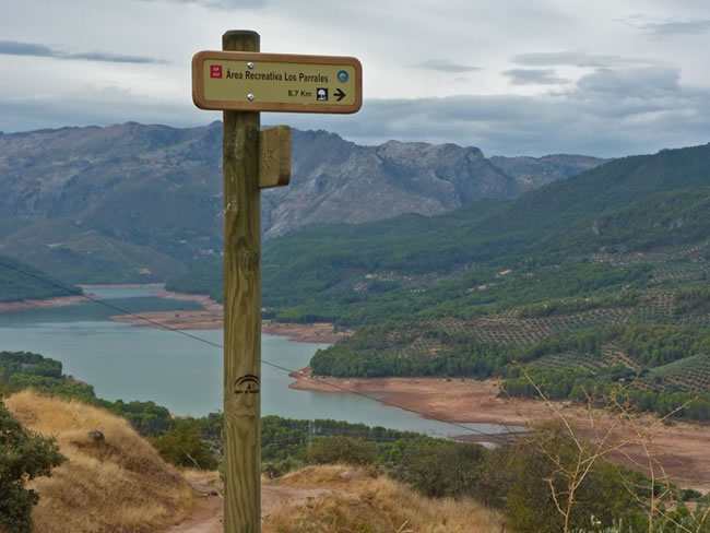
The stage ends at the Los Parrales Recreation Area, one of the best viewpoints over the El Tranco reservoir, which covers the old Vega de Hornos and which, with its almost 500 cubic hectometres of capacity, is one of the largest in Andalusia. It is a delight to contemplate its calm waters reflecting the forests that cover the mountains that surround it.
This stage is very short, so it can be complemented with a pleasant walk near the banks of the reservoir, along a signposted path, with hardly any unevenness and of great scenic beauty.
Technical information
Route Name Rutas Bosques GR247
Rutas Bosques GR247 4: Hornos de Segura – Área Recreativa Los ParralesHUSO 30S
Hornos de Segura: x524749 y4229899
Área Recreativa Los Parrales: x520092 y4226747
Hornos de Segura: x524637 y4229692
Área Recreativa Los Parrales: x519980 y4226540
TOTAL DISTANCE (IN KILOMETERS)8700
Asphalt or cement section 2,29 %
Section of track or forest road or promenade 76,24%
Senda section 21,47 %
tramos-de-Vía-pecuaria 0%
ESTIMATED RUN TIMEO
3 h 5 minMAXIMUM SLOPE233 m
DIFFICULTY. ASSESSMENT ACCORDING TO METHOD MEASURE
1
MEDIO.
Severity of the natural environment
1
Itinerary
Orientation in the itinerary
1
Displacement
Difficulty moving
2
EFFORT.
Amount of effort required
TOTAL DISTANCE (IN KILOMETERS) 19540 M
Start
Hornos de Segura is reached by the A-317 road; The Stage begins at the exit of the town towards La Platera and Pontones.
Final
The Parrales Recreational Area, between the Tranco Dam and the Cañada Morales village, is reached through a 300-meter forest track that starts from the A-319 road.
CYCLABILITY
Steep slopes on the path near Hornos
WATER POINTS
Hornos de Segura, Los Parrales
PREFRESHING POINTS
On the trail: Hornos de Segura
Near the trail: No
LINKS WITH OTHER TRAILS
PR-A 194; PR-A 147; PR-A 148; PR-A 150
Rutómetro
Segura ovens
The route starts from the beautiful town of Hornos de Segura, declared a Historic-Artistic Site and from which you can see a large part of the territory that the Bosques del Sur trail runs through. Its old Moorish castle has been restored as a planetarium and astronomical interpretation center, and a visit is highly recommended.
The starting point is at the exit of the town on the A-317 in the direction of Pontones. Just when we leave the last houses, our path begins to the right along a narrow downhill forest track where we can see a trough for cattle. After just 50 meters we will have to turn right, following another quite narrow track, which seems to surround the town on the way down, gradually moving away from it.
Bridle path
The track, whose state is more deteriorated as we advance, disappears and we continue along an old bridle path, used since ancient times by the horsemen to access the town from the farmhouses of Vega de Hornos. Hence the sinuous route, to go up and down in a zigzag avoiding the steep slope of the terrain. The olive groves that we visit have a marked landscape personality, since they grow on steep slopes and are continuously intermingled with forest patches. They are crops whose production is not large, but which give an oil of extraordinary quality. These olive groves are of great importance in the economy, popular culture and daily life of the people of the natural park. A part of them are grown according to the rules of organic farming.
Just 300 meters further down, the bridle path leads to a forest track that gives access to the many olive groves that surround us. We must continue along the same, to the left and continuing the descent.
Asphalt forest track
Perpendicular to the direction of travel we discover a wider track, currently paved, which runs along one of the flanks of the north tail of the El Tranco Reservoir and serves as access to farmhouses such as Carrascal, La Platera or Fuente de la Higuera, all inhabited. Our route turns to the right at this point, to cross this asphalt track, crossing 100 meters above the Arroyo de los Molinos. This usually maintains a fairly regular flow and brings water from the high areas of El Yelmo Chico and La Cumbre. In this section, the magnificent gallery forest formed by the Hornos River and some of its tributaries before its mouth in the reservoir, formed mainly by willows, poplars and especially tarayes, draws attention to the left. At 300 meters our track leads to a wide A-319 road in better condition. We turn left to cross the Hornos river, taking advantage of the bridge on that road.
Junction with road A-319
When crossing the Hornos river, we turn left again to take another narrow forest track that runs along the other side of the El Tranco reservoir and is used mainly to give way to small olive farms. The landscape in this area is quite diverse, on the one hand the agrosystems of olive groves and on the other hand Aleppo pine forests mixed with holm oaks and the occasional oak (gall) and hawthorn. All this accompanied by an abundant undergrowth formed by mastic, rosemary and kermes oak.
Chorreón bridle path
The track narrows to end up becoming a path that becomes quite narrow at some points. At about 300 meters, the path takes a little height to save some rocks that constitute a true natural viewpoint, from which we are given wonderful views of the reservoir and its surroundings. About 300 meters further on, we pass the ruins of old farmhouses on the left that were left uninhabited during the construction of the reservoir during the 1940s. If the water level is not very high, even the old stone beds that were used to separate the grain from the chaff can emerge.
Meeting with PR-A 193
At this point we find the PR-A 193 trail, which to the right, in 2 kilometers, would take us to the village of Cañada Morales, and in front it coincides with our route for several kilometers. From this point the signposting of our stage will be white, red and yellow, as a GR path coincides with a PR. A mere 100 meters to the left is one of the route's greatest attractions, the Chorreón Waterfall, formed by the waters of the Arroyo de Cañada Morales as it plunges from a certain height onto the calm waters of El Tranco. During the spring and autumn months, with the rains, it is more spectacular than in the summer.
From here the path becomes a narrow forest track again, and the landscape is dotted again with some olive trees. Two kilometers away we pass the ruins of the Cortijo de Montillana, also uninhabited since the construction of the reservoir.
Olive track towards Montillana-Parrales
Our route separates from the PR-A 193, which continues in front, following the reservoir in parallel. This PR is a road marked with white arrows and white and yellow marks, with hardly any unevenness and of great scenic beauty. If we continue along it, we will reach the reservoir dam, walking the A-319 along the last road section.
Our stage, however, takes us to the right, along narrow tracks in olive groves that gradually gain height, expanding the panoramic views that we can enjoy. Since this is the shortest stage of the Bosques del Sur trail, we could well continue on PR-A 193 to the dam and then return to this point to continue it. Or also, once at the dam, return along the A-319 –direction to Cañada Morales– to the Los Parrales and Montillana Recreational Area, where stage 4 ends and stage 5 begins.
Montillana and Los Parrales Recreation Area
Again we connect with the A-319, right in front of the Montillana campsite. Here the olive groves disappear to give way to exceptional Aleppo pine forests with dense Mediterranean scrub. A few meters to the left is the access by forest track to the recreational area. This area is one of the best viewpoints over the El Tranco reservoir, which covers the old Vega de Hornos and which, with its almost 500 cubic hectometres of capacity, is one of the largest in Andalusia. It is a delight to contemplate its calm waters reflecting the forests that cover the mountains that surround it.
If instead of going down to the recreational area we continue along the road, we will immediately find on the right a crossroads with a forest track that is the beginning of stage 5.
Additional information
One of the best oils in Spain
During some sections of this stage we are in contact with mountain olive crops. These olive groves are not the ones with the greatest quantity of production, but they do have a recognized quality, guaranteed by the Denomination of Origin of Extra Virgin Olive Oil (EVOO) Sierra de Segura. To the south of the natural park, another denomination of origin for EVOO, that of Sierra de Cazorla, also supports the production of oils.
These oils are pure olive juice that captivates the eye with its clean greenish color, a prodigy of Mediterranean gastronomy that give the palate its mature balance of fragrant aromas, fruity flavors –with hints of fig tree, apple ...–, and the pleasant slightly bitter final touch typical of the Picual variety olives. The Sierra de Cazorla denomination also produces Royal variety oil, with different organoleptic characteristics. They are highly stable oils which allow them to maintain their characteristics for a long period of time.
In the kitchen, these extra virgin oils g ...
One of the best oils in Spain
During some sections of this stage we are in contact with mountain olive crops. These olive groves are not the ones with the greatest quantity of production, but they do have a recognized quality, guaranteed by the Denomination of Origin of Extra Virgin Olive Oil (EVOO) Sierra de Segura. To the south of the natural park, another denomination of origin for EVOO, that of Sierra de Cazorla, also supports the production of oils.
These oils are pure olive juice that captivates the eye with its clean greenish color, a prodigy of Mediterranean gastronomy that give the palate its mature balance of fragrant aromas, fruity flavors –with hints of fig tree, apple ...–, and the pleasant slightly bitter final touch typical of the Picual variety olives. The Sierra de Cazorla denomination also produces Royal variety oil, with different organoleptic characteristics. They are highly stable oils which allow them to maintain their characteristics for a long period of time.
In the kitchen, these extra virgin oils give stews a very characteristic taste. They are perfect for frying, because they resist high temperatures without alteration. When raw, they add their aromatic character to salads and toasts.
Excellent certified organic oils are also produced in the natural park, such as those from the municipality of Génave. Its farmers were among the first in Andalusia to cultivate their olive trees, combining traditional knowledge with modern methods of organic farming.

Follow us #JaénParaísoInterior


