


Las Acebeas - Navalperal

This route, which coincides with the PR-A 176 path, allows you to admire one of the most unique botanical enclaves on the Iberian Peninsula and enjoy wonderful panoramic views. In the area of ??Las Acebeas there is an especially humid and cool microclimate. Thanks to it, a surprising hazelnut tree grows under the black pine canopy - the southernmost in Spain - with an abundance of large holly trees.
Climbing plants such as ivy and clematis abound, and there are very rare species in Andalusia, such as wild strawberry and noble liverwort. The complex transmits a sensation of freshness and abundance of vegetation typical of northern forests.
As we ascend, there are holm oaks, maples and oaks mixed with the pines, and finally the vegetation clears up giving way to the broom and the browning. The route ends at the guardhouse, an aerial promontory from which wide views can be enjoyed. Before going down, we recommend a walk through the Navalperal calar to enjoy its meadows and its typical karst landscape.
The exceptional nature of the hazelnut and holly forest in southern Spain, together with the presence of numerous endemic or endangered plant species, have led to this area being declared a Las Acebeas-Nava del Espino Reserve Area. It therefore enjoys the highest level of protection within the Natural Park.
Technical information
Route Name Rutas Bosques GR247
Rutas Bosques GR247 10: Las Acebeas - NavalperalHUSO 30S
Las Acebeas: x537220 y4241557
Caseta de vigilancia forestal: x536369 y4241206
Las Acebeas: x537109 y4241350
Caseta de vigilancia forestal: x536258 y4240999
TOTAL DISTANCE (IN KILOMETERS)3350
Asphalt or cement section 0 %
Section of track or forest road or promenade 83.58 %
Senda section 16.42 %
tramos-de-Vía-pecuaria 0 %
ESTIMATED RUN TIMEO
1 h 28 minMAXIMUM SLOPE295
DIFFICULTY. ASSESSMENT ACCORDING TO METHOD MEASURE
1
MEDIO.
Severity of the natural environment
1
Itinerary
Orientation in the itinerary
2
Displacement
Difficulty moving
2
EFFORT.
Amount of effort required
Rutómetro
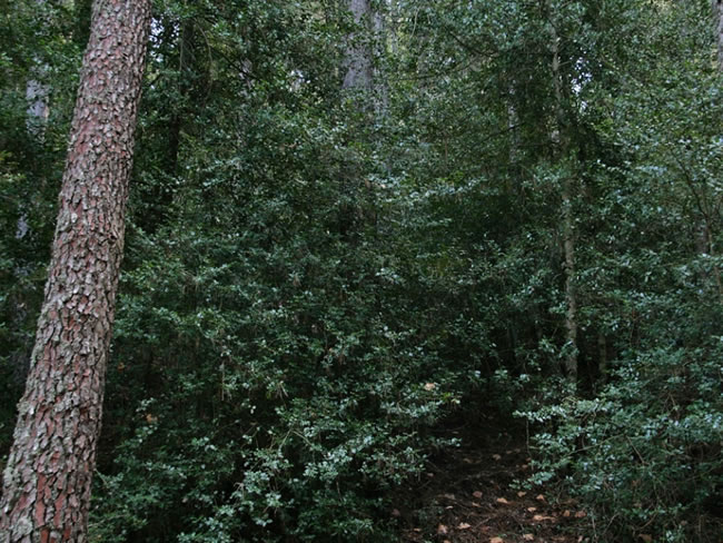
The Acebeas
The first 600 meters of the route run along a wide and delicious path, almost flat, between holly trees, hazelnuts, ivy and other plants that make us feel almost like in a forest in the north of Spain. The presence of wild boar, deer and fallow deer is notable in this lower part of the route.
Shortly before arriving at the Casa Forestal de Las Acebeas we cross a path marked to the left, in the opposite direction, which corresponds to Stage 21 of the Bosques del Sur Trail. It is highly recommended to deviate along this path and travel about 500 meters to enter this impressive forest to the Barranco de los Acebos.
The Forest House has a fountain and consists of two beautiful houses, which in the past were used by the rangers and forest engineers, with several yew trees planted next to them. The houses are well preserved and in 2011 an agreement was signed between the Junta de Andalucía and the Catalan Institute of Climate Sciences for their use as an observatory of the impact of climate change. The place could not ...
The Acebeas
The first 600 meters of the route run along a wide and delicious path, almost flat, between holly trees, hazelnuts, ivy and other plants that make us feel almost like in a forest in the north of Spain. The presence of wild boar, deer and fallow deer is notable in this lower part of the route.
Shortly before arriving at the Casa Forestal de Las Acebeas we cross a path marked to the left, in the opposite direction, which corresponds to Stage 21 of the Bosques del Sur Trail. It is highly recommended to deviate along this path and travel about 500 meters to enter this impressive forest to the Barranco de los Acebos.
The Forest House has a fountain and consists of two beautiful houses, which in the past were used by the rangers and forest engineers, with several yew trees planted next to them. The houses are well preserved and in 2011 an agreement was signed between the Junta de Andalucía and the Catalan Institute of Climate Sciences for their use as an observatory of the impact of climate change. The place could not be more suitable, since precisely the uniqueness of the vegetation of Las Acebeas is an exceptional testimony of the great climate change that the last ice age caused.
Next to the House, the forest track narrows and turns left, which is where our route continues. To the right we would follow the route of Stage 21 towards the Peña del Olivar.
The path ascends between pine trees, with some oaks (gall oaks), holm oaks, maples and holly trees. Little by little great views to the east and north will appear, being able to make out the characteristic flattened profiles of the calares of the Sierra de Segura. The vegetation becomes scarcer as we go up, to be reduced at the top of the cave to some gnarled pines, hawthorns and broom.
Track
We leave the forest track and turn left onto a small path that cuts in the direction of the forest guardhouse. The path passes through a small meadow and heads towards the cliff where the house is located.
Forest guardhouse
It is located at the southern end of the long Navalperal calar, at an altitude of 1,640 meters, and constitutes one of the best viewpoints in the Natural Park. The impressive panoramic views cover territories in the provinces of Jaén, Ciudad Real, Albacete and Granada. To the north you can see the plains of La Mancha, the Cambrón and the mountains of the Sierra de Alcaraz, where La Sarga and Almenaras stand out.
To the west, the cliffs of Segura La Vieja, the upper valley of Trujala, Orcera and the keep of the castle of Segura de la Sierra. To the south we see El Yelmo and in the background Banderillas, the great mass of La Sagra and the Sierras de Las Villas and Cazorla. And to the east we contemplate the calares del Mundo, the Mentiras, the Navalespino and the Morillas.
It is frequent the observation of mountain goats, vultures and birds of prey such as the peregrine falcon and the short-toed eagle.
To return, it is recommended to do it along the section of track that we leave when we take the pa ...
Forest guardhouse
It is located at the southern end of the long Navalperal calar, at an altitude of 1,640 meters, and constitutes one of the best viewpoints in the Natural Park. The impressive panoramic views cover territories in the provinces of Jaén, Ciudad Real, Albacete and Granada. To the north you can see the plains of La Mancha, the Cambrón and the mountains of the Sierra de Alcaraz, where La Sarga and Almenaras stand out.
To the west, the cliffs of Segura La Vieja, the upper valley of Trujala, Orcera and the keep of the castle of Segura de la Sierra. To the south we see El Yelmo and in the background Banderillas, the great mass of La Sagra and the Sierras de Las Villas and Cazorla. And to the east we contemplate the calares del Mundo, the Mentiras, the Navalespino and the Morillas.
It is frequent the observation of mountain goats, vultures and birds of prey such as the peregrine falcon and the short-toed eagle.
To return, it is recommended to do it along the section of track that we leave when we take the path, which makes a wide and smooth loop around the central area of ??the calar. This will allow us, extending the return about fifteen minutes, to take a relaxing walk on its platform and look out to its edges to discover new panoramic views and see some surprising places, such as the small Laguna de la Hueta, which only has water during the humid months and which constitutes one of the very few endorheic wetlands of the Natural Park.

Follow us #JaénParaísoInterior


