


The climate
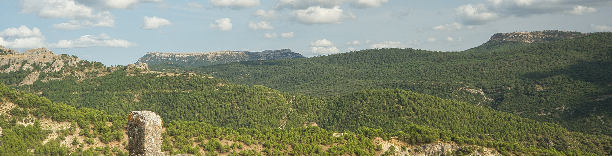
The mountains of the Park have a lot of character, with all their own climatic features, but none is given in excess. The cold has its time, especially in the highlands. It will be the moment to enjoy the snow and the fireplace. In addition, the lower areas have more than bearable winters. The heat also has its moment, but the omnipresence of the mountains and the vegetation temper its rigors and cool the nights.
In addition, summer is perfect for strolling through the shady pine forests of the high areas, the abundant shadows and the banks of rivers and streams. The balance and temperance of spring and autumn make them, of course, the most desirable seasons.
And, if what you are looking for is light, do not forget that this is Andalusia.
Precipitation
The natural park is one of the wettest parts of Andalusia and a true oasis in relation to the geography of the surrounding area, owing to its high average altitude and the general northeast-southwest orientation of its mountain ranges. The mountains in the park stretch for over 100 kilometres and have a significant barrier effect against weather fronts coming in from the Atlantic, which causes air to rise and in turn prompts the formation of clouds.
In addition, the Segura valley enables Mediterranean weather systems to penetrate the park, which have a particular effect on the northeastern areas and generate rainfall at those precise times of the year when Atlantic squalls are less frequent, such as the end of summer and the beginning of autumn. Naturally, not all the areas of the park receive the same amount of precipitation: the level increases according to altitude and also varies (to a lesser extent) depending on the orientation of the mountain slopes in relation to the ...
The natural park is one of the wettest parts of Andalusia and a true oasis in relation to the geography of the surrounding area, owing to its high average altitude and the general northeast-southwest orientation of its mountain ranges. The mountains in the park stretch for over 100 kilometres and have a significant barrier effect against weather fronts coming in from the Atlantic, which causes air to rise and in turn prompts the formation of clouds.
In addition, the Segura valley enables Mediterranean weather systems to penetrate the park, which have a particular effect on the northeastern areas and generate rainfall at those precise times of the year when Atlantic squalls are less frequent, such as the end of summer and the beginning of autumn. Naturally, not all the areas of the park receive the same amount of precipitation: the level increases according to altitude and also varies (to a lesser extent) depending on the orientation of the mountain slopes in relation to the sun and the wind.
The park's climate has two distinct sub-regions: the first coinciding with the central, mountainous nucleus, where the average altitude is around 1,200 m and annual precipitation is in excess of 800 mm (1 mm = 1 litre/m2), with two "rain islands" where average precipitation greatly exceeds 1,000 mm. The second sub-region is on the edge of the park and has an average altitude of between 900 and 500 m and annual precipitation of between 600 and 800 mm, with a drier area in the extreme south receiving less than 500 mm per year.
As is typical with a Mediterranean climate, the park suffers from significant droughts in summer, although the heavy forest cover, rivers and streams and mountainous terrain ensure that this particular season is always temperate. Rainfall is usually abundant during autumn and winter, while in spring (and especially towards the end of summer) it can often be torrential, which causes the rivers to rise significantly: in fact, the park receives more summer storms than anywhere else in Andalusia.
Snow is an integral part of the landscape for much of the park and is a daily reality for those inhabiting the higher parts of the Segura mountains during winter. Areas above 1,800 metres experience 20 to 30 days of snowfall per year; moving down the slopes, those areas between 1,300 and 1,800 metres receive 10 to 20 days of snow per year while those beneath 1,300 metres, which is where the majority of towns and villages are located, experience just 3 to 10 days of snowfall annually. The snows do not usually linger, except on occasion in Campos de Hernán Pelea and on the highest peaks, where snowfields can remain until May.

Temperatures
Temperatures fall as the altitude increases, with the exception of a few isolated and enclosed spaces on the valley floors in which the phenomenon of temperature inversion occurs. In general, however, the temperature drops by 0.5 to 0.6°C per 100 m as you travel higher. This gives rise to great contrasts in temperature over short distances, owing to the uneven nature of the mountain terrain.
As a result, in the less mountainous western parts of the northeast region of the park, and in the far south, summers are hotter and winters are milder than in the higher reaches, where summers are not particularly hot and winters can be especially severe.
To illustrate the contrasts in temperature, the area around the Canales stream (part of the Madera River system) reaches an average low of -3.2°C during its coldest month, while the equivalent for Beas de Segura is just 4.9°C. The average maximum temperature for the hottest month in Las Acebeas is 29.3°C, compared to 36.4°C in ...
Temperatures fall as the altitude increases, with the exception of a few isolated and enclosed spaces on the valley floors in which the phenomenon of temperature inversion occurs. In general, however, the temperature drops by 0.5 to 0.6°C per 100 m as you travel higher. This gives rise to great contrasts in temperature over short distances, owing to the uneven nature of the mountain terrain.
As a result, in the less mountainous western parts of the northeast region of the park, and in the far south, summers are hotter and winters are milder than in the higher reaches, where summers are not particularly hot and winters can be especially severe.
To illustrate the contrasts in temperature, the area around the Canales stream (part of the Madera River system) reaches an average low of -3.2°C during its coldest month, while the equivalent for Beas de Segura is just 4.9°C. The average maximum temperature for the hottest month in Las Acebeas is 29.3°C, compared to 36.4°C in La Puerta de Segura.
As well as the altitude factor, temperatures are also affected by the orientation of the mountain slopes. In the park this orientation is very varied, owing to the great orographic complexity of the mountain ranges: the alternating areas of shade and sun exacerbate local variations in temperature and precipitation.
Frost is more prevalent in the east and at higher altitudes; it is present in the most mountainous areas throughout two-thirds of the year, while lower areas only experience around three months of frost.
Wind
Winds are generally gentle, with the exception of the high peaks. The locals distinguish between several different types of wind: the cierzo, a cold northern wind; the levante or solano, a warmer wind from the southeast; the morisco ("Moorish") or granaíno ("Granada-born"), which comes from the south and often brings rain; the ábrego, from the west; and the manchego, a wind from the northwest that is frequently accompanied by violent storms.


