


Refuge House Forestal La Zarza - La Iruela

This long stage runs through the most western mountains of the natural park. Its route is between two very different landscapes. To the east is the headwaters of the Guadalquivir River Valley, which flows northward. It has a remarkable ecological value and is flanked by large limestone mountains covered by dense forest vegetation that exceed 1500 meters in altitude. To the west is the agricultural landscape of the countryside of the Loma y el Valle region that the Guadalquivir River forms when, outside the park, its course turns south. These are territories of wide horizons, with gentle hills covered by a sea of olive trees.
The first part of the journey is done entirely by forest track until you reach Puerto de las Palomas. After that, we will alternate recovered paths and repopulation tracks until we reach the Cuerda del Viñuela, and from there we will travel along one of the most powerful bridle paths of the Bosques del Sur trail, with imposing moulds, wedges and dry stone works, until we reach the Ermita de la Virgen de la Cabeza, very close to La Iruela and Cazorla.
Remember ...
This long stage runs through the most western mountains of the natural park. Its route is between two very different landscapes. To the east is the headwaters of the Guadalquivir River Valley, which flows northward. It has a remarkable ecological value and is flanked by large limestone mountains covered by dense forest vegetation that exceed 1500 meters in altitude. To the west is the agricultural landscape of the countryside of the Loma y el Valle region that the Guadalquivir River forms when, outside the park, its course turns south. These are territories of wide horizons, with gentle hills covered by a sea of olive trees.
The first part of the journey is done entirely by forest track until you reach Puerto de las Palomas. After that, we will alternate recovered paths and repopulation tracks until we reach the Cuerda del Viñuela, and from there we will travel along one of the most powerful bridle paths of the Bosques del Sur trail, with imposing moulds, wedges and dry stone works, until we reach the Ermita de la Virgen de la Cabeza, very close to La Iruela and Cazorla.
Remember that at the beginning of this stage there is a link with the GR 247.2 variant - stage 2 - which allows for an alternative route connecting with the valley, and on a second day with stages 16 and 17.
In the surroundings of Puerto de Las Palomas, the route covers a wide area that was hit by a fire in 2001. In spite of this, the botanical and faunistic richness that we will find is exceptional. Forests of laricio and negrales pines, oaks, quejigales, savins, junipers, cornicabras, majuelos, maples and an understory with much boxwood, provide the ideal conditions to lodge great herbivores, raptors, carrion eaters and great amount of insectivore birds.
At the end of the route, in the hermitage of the Virgen de la Cabeza, we will have the option of finishing the stage in the Iruela, or accessing Cazorla through another path also signposted, the GR 7. Both villages have been declared as Historic-Artistic Sites and have a wide range of infrastructures and tourist services, which will allow us to enjoy and rest before continuing our journey. Cazorla is the starting point for two other stages of the Bosques del Sur path, on the one hand stage 11 towards the Casa Forestal de Collado Zamora refuge, and on the other, stage 1 of the GR 247.3 variant that would take us to the refuge of the Sacejo forest house, next to the Parador de Cazorla.
*** Translated with www.DeepL.com/Translator (free version) ***
Technical information
Route Name Rutas Bosques GR247
Rutas Bosques GR247 10: Refuge House Forestal La Zarza - La IruelaHUSO 30S
Refugio casa forestal La Zarza: x507476 y4206240
La Iruela: x500835 y4197145
Refugio casa forestal La Zarza: x507365 y4206033
La Iruela: x500724 y4196938
TOTAL DISTANCE (IN KILOMETERS)20820
Asphalt or cement section 1,45 %
Section of track or forest road or promenade 51,88 %
Senda section 46,67 %
tramos-de-Vía-pecuaria 0 %
ESTIMATED RUN TIMEO
7 h 35 minMAXIMUM SLOPE361 m
DIFFICULTY. ASSESSMENT ACCORDING TO METHOD MEASURE
2
MEDIO.
Severity of the natural environment
2
Itinerary
Orientation in the itinerary
2
Displacement
Difficulty moving
4
EFFORT.
Amount of effort required
TOTAL DISTANCE (IN KILOMETERS) 19540 M
Start
There is no open access to public road traffic.
Final
The Iruela can be reached by the A-319 road.
INTERMEDIATE POINTS
PLACE
POSITION
TYPE OF ROAD
Km 7,2
Carretera
CYCLABILITY
Between points 6 and 8 there are steep slopes and very narrow sections of the path. From Prado Redondo to the hermitage of the Virgen de la Cabeza there are steps, steep slopes and very loose stone.
WATER POINTS
In the vicinity of the Refugio Casa Forestal de la Zarza, Casa Forestal del Sagreo, Fuente de Rechita, Fuente 500 metros más delante de la anterior, Casa Forestal Prado Redondo, ermita Virgen de la Cabeza, La Iruela.
PREFRESHING POINTS
On the trail: La Iruela
Near the trail: Burunchel, Arroyo Frío, Cazorla
Rutómetro
La Zarza Forest House Shelter
The stage begins by following the forest track of La Zarza in a southwesterly direction. The path is flat at first, and after 400 meters we leave the ruins of the Cortijo del Tío Comino on the right. The exceptional size of the trunk of some centenary oaks (quejigos) that we find here, next to black pines and laricios, is remarkable.
Crossroads to Cortijo Poyo del Rey
To the right we left a track that would take us to Cortijo Poyo del Rey and the Hoyo Redondo forest house, among other places. Our route continues to the front with great views towards the head of the Guadalquivir Valley. Soon we notice, on the other side of the valley towards the south, the great platform of vertical walls that appears in front of us. This is the Poyos de la Mesa, a very well known and visible limestone quarry in this area of the park.
At 250 meters we find the first of the fences of this route, whose purpose is to limit the access of herbivores to areas where the vegetal cover is being recovered, so, like all the others, we must not forget to close them after our passage.
Later, from the kilometer 3, we change of slope, giving view to the zone of countryside of the province of Jaén, with great extensions of olive trees. La Cruz, the Albardas, and the Peña de la Sabina are some of the peaks near this forest track. In the kilometer 4, 8 we find another door of repopulation, passed the Peña de la Sabina.
Crossing tracks
Towards the right, a forest track appears that we discarded. We continue to the front, after 400 meters we will leave another track to the left, which is not very busy. At kilometer 5.8 a barrier prevents access to motor vehicles. Following our track we will find at 300 meters another crossing that we discarded again and that goes up to the right to the Cerro del Mosco, of 1316 meters of altitude, easily identifiable because it has several antennas.
Puerto de las Palomas and Derivation to Arroyo Frio
The forest track we walk along is known as the old Salto del Moro path, and it runs practically on a flat surface. Soon, to the left, we will see the sign that indicates the beginning of the derivation 4 to Arroyo Frio, of 2.4 kilometers in length. After a few meters we cross a Canadian pass, a horizontal grid system over a moat with a certain depth that avoids the passage of animals, and a little further on a repopulation control gate. We arrive at the asphalted road A-319, where we will have to turn to the left, to cross it and turn quickly to the right, through a restored path. If we follow the road to the left, after 300 meters we will reach the viewpoint of Paso del Aire, in the same Puerto de las Palomas.
Continuing our path we walk through a lush forest of oaks mixed with cornicabra and some laricio pines. This area did not suffer the fire of 2001, so we can still see the high ecological value of the disaster area.
Track of the El Sagreo Forest House
Our path links up with a narrow forest track that we must take to the left, passing after 200 metres next to the Sagreo fountain and forest house. The track is uphill and is closed to vehicle traffic by a barrier, just past the forest house. A short distance from it we find another forest control gate, which as always we must leave closed. The lack of trees in this section allows us to enjoy the view of the olive grove countryside to the west. The red kites accompany us on our walk, together with capuchin tits, common coalmen and other small insectivorous birds that find a great deal of food in these areas.
Natural viewpoint and bifurcation of tracks
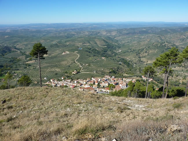
The views to the right are great: the massif of Sierra Mágina, Sierra Morena, the Loma de Úbeda, Villacarrillo, and thousands of olive trees lined up in different directions over the undulating terrain that occupies most of the province of Jaén, forming its productive countryside. At our feet is Burunchel, already in the limit of the protected space, a town belonging to the municipality of La Iruela, which is an obligatory step for the visitors who enter the interior of the park through the Puerto de las Palomas.
At this point we find two alternative tracks. The first one, in front and practically flattening. And the second one, which is the option we must follow, to the left, with less use and much more slope, since it winds gaining height quickly. Finally our route maintains the dominant direction that we have brought since the beginning of the stage. On the left we see the Viñuela, a mountain with steep slopes and little vegetation cover. Despite being fenced in as a result of the aforementioned fire in 2001, it is relatively common to find mountain goats in this terrain, taking advantage of the little competition for food here.
The track ends and we must continue by path, in smooth ascent, until the hill located towards the south.
Viñuela Rope
When we reach this rope we will crests towards the southwest to continue our route, but if we feel strong in spite of the length of the stage we can take advantage of it to ascend towards the geodesic vertex of Viñuela, for which we will have to detour and go high towards the north along about 700 meters.
Continuing our route along the rope towards the southwest, at 200 meters we reach another new forest restoration control gate. After passing it, the forest is suddenly present again, a forest of black pines with a large amount of boxwood, a species that will be very abundant until the end of the stage. To the east, in the valley of the headwaters of the Guadalquivir, the green and lush forests of the park dominate, while to the west the ochre and silvery green of the olive trees in the countryside.
Collado
We arrive at a hill in front of the Puntal de Correas and our route leaves the ridge to turn right along a wide path, with stone walls and wedges, which turns over and over again to descend gently, adapting to the capricious orography of the area.
We walk immersed in the forest, and at kilometer 12.5 another path enters from the right that we must avoid, continuing to the front.
Rechita
On the left, the GR 7 converges with our path, with which we will coincide until the end of the stage. To the right, below where we are, some poplars indicate the location of the water source of the Rechita stream, which will allow us to refresh ourselves, and 200 meters further on, on the left, we find an old shepherd's shelter.
Another 500 meters further on we will find another small fountain, on the left side of the path. We go along the hill Escribano, also located on the left, and soon the Castle of the Iruela indicates the proximity of the end of the stage.
Crossroads of Paths
We find a wide path that descends to the right and that would take us quickly to the A-319 road, already very close to La Iruela. Our route, however, continues to the front, to climb a zigzagging path up the slope of La Mocha, devoid of trees. It is a rather peculiar stretch, since its atmosphere resembles that of the high areas in spite of being in a relatively low area of the park. In fact, you can climb 200 meters in barely 1.5 kilometers of path.
Prado Redondo Forest House
We arrive at Prado Redondo, an old forest house in ruins, next to small terraces formerly used in self-supply agriculture. A magnificent bridge over which our path passes, built in stone masonry, calls our attention. There are still some walnut trees, poplars, elms and cherry trees that in autumn impregnate this place with color. Near the house there is a fountain-trough to which water is usually brought with a hose from a spring in Cerro Escribano, just next door.
From this point onwards, we will find signs for other short distance and local paths that coincide, such as the PR-A 313 and the SL-A 8, so the continuity signs that we will find are white, red, yellow and green. There is an electric line that accompanies us and serves as a reference in this winding path and sometimes carved into the rock, where we can admire botanical species linked to the rock of great interest, given its limited distribution. As for the fauna, it is an area par excellence for the mountain goat, which we can see if we are attentive.
Virgen de la Cabeza Hermitage
We go out to a clearing in the forest and below us we contemplate the hermitage situated on top of a hill, overlooking the village of Cazorla. It is a white construction, with a rectangular floor plan, which houses the patron saint of Cazorla, venerated since the 16th century. In the place there is a magnificent fountain.
At this point we must turn right, to go to the end of the stage in the Iruela. The distance between this village and Cazorla is less than 1 kilometer, so the place to stay will depend on our preferences and the time of arrival. If from the hermitage we choose to arrive directly to Cazorla we will have to follow the indications of the GR 7. To do so, we will go down the track that we see below us, which leads to a circular viewpoint where we will take a path on the right that descends to Cazorla. If we decide to go to La Iruela, from the hermitage we must follow the track to the right.
The Iruela
We will enter this charming village through the area of the sports center, on a paved road flanked by cypresses, next to a meadow where it is common to see in spring the Cazorla hyacinth (Scilla reverchonii) and the dwarf daffodil (Narcissus hedraeanthus), endemic to these mountains. Finally we arrive at Esperilla Alta street in the Iruela, the end of this long stage, seeing on the right its castle and watchtower next to the ruins of the Church of Santo Domingo, monuments all of them of essential visit.
Stage 11, as reflected in the directional pole at the end of this stage, begins on the outskirts of Cazorla, at the foot of the castle of La Yedra. In any case, the movement between both towns is small and they form almost a continuous urban area. Near the beginning of stage 11 is also the beginning of the GR 247.3 variant, as explained in the corresponding chapter of this topoguide.
Additional information
Cazorla and La Iruela
These two villages, very close to each other, deserve to be considered in a very special way by the walker. Cazorla, with its 8,000 inhabitants, has a wide range of services, but, above all, it is a place to walk around slowly, strolling through its Historic-Artistic Site, contemplating its monuments and its traditionally made urban fabric. Cazorla is a harmonious blend of two universes: downwards, the village looks at the hills covered with olive trees, whose fruits are used to produce an excellent extra virgin olive oil with designation of origin; upwards, the eyes are filled with forest and rock, almost untouched by nature. Cazorla, strategically located, allows you to contemplate those two worlds from its windows full of flowers, from its viewpoints, from its white streets.
Don't miss the castle of La Yedra, undoubtedly the most distinctive historical construction in Cazorla, which houses the Museum of Popular Arts and Customs of the Upper Guadalquivir, where you can learn about the history of the Adelanta ...
Cazorla and La Iruela
These two villages, very close to each other, deserve to be considered in a very special way by the walker. Cazorla, with its 8,000 inhabitants, has a wide range of services, but, above all, it is a place to walk around slowly, strolling through its Historic-Artistic Site, contemplating its monuments and its traditionally made urban fabric. Cazorla is a harmonious blend of two universes: downwards, the village looks at the hills covered with olive trees, whose fruits are used to produce an excellent extra virgin olive oil with designation of origin; upwards, the eyes are filled with forest and rock, almost untouched by nature. Cazorla, strategically located, allows you to contemplate those two worlds from its windows full of flowers, from its viewpoints, from its white streets.
Don't miss the castle of La Yedra, undoubtedly the most distinctive historical construction in Cazorla, which houses the Museum of Popular Arts and Customs of the Upper Guadalquivir, where you can learn about the history of the Adelantamiento de Cazorla and see a wonderful collection of agricultural tools and traditional tools, as well as a recreation of the typical Cazorla cuisine and several models that show how oil was made in the old oil mills. The castle building itself, with its dungeons and its sturdy homage tower, is in itself a journey back in time.
Among the many places that pleasantly surprise in Cazorla is the Plaza de Santa María. Here, and in its immediate surroundings, the historical heritage, the gastronomy and the atmosphere of the more traditional quarters are brought together. In the same square and in its surroundings there are two places that are a must to visit. The first one is the Thematic Center of Threatened Species, next to the Cerezuelo River, which brings us closer to the most representative ecosystems of Andalusia and to the situation of some of its most emblematic species, such as the Egyptian vulture and the bearded vulture. The second one is the Thematic Center Frondosa Naturaleza, an excellent exhibition about the natural park that in its moment traveled to several capitals throughout Spain.
But Cazorla, in addition to its rural atmosphere, exhibits another very interesting facet, the cultural one, in which events as consolidated as its theater and blues festivals stand out. In short, Cazorla is a town that dazzles with its beauty, its gastronomy, its atmosphere and its dynamism.
La Iruela is a small town declared Historic-Artistic Site and located right next to Cazorla, from which it became independent in 1370. The implausible silhouette of its castle tower, perched on a rough and vertical rocky spur, is one of the most photographed images of the natural park. The conquest of this fortress of Muslim origin must have been a hard nut to crack. Both from it and from the walks enabled in its enclosure you can contemplate extraordinary views, not only of the valley of the Guadalquivir and the olive groves, but of a good part of the province of Jaén.
Also worth seeing are the Town Hall, a magnificent building in the Toledo Mudejar style that tells us of the power the town had in the 16th and 17th centuries, and the church, now in ruins, of Santo Domingo de Silos, which denotes traces of the unmistakable Vandelvira style. But in addition to these architectural landmarks, the white and steep streets of La Iruela have a charm that will captivate the walker and invite him or her to take a leisurely stroll through them to discover corners such as the Fuente del Molino or the municipal wash house.

Follow us #JaénParaísoInterior


