


Refugio Casa Forestal de El Campillo - Hornos de Segura

This stage joins the beautiful black pine forests of Mount El Yelmo with the Historic-Artistic Complex of Hornos de Segura, allowing us to enjoy a delicious variety of environments, from the purely wooded to the most humanized ones.
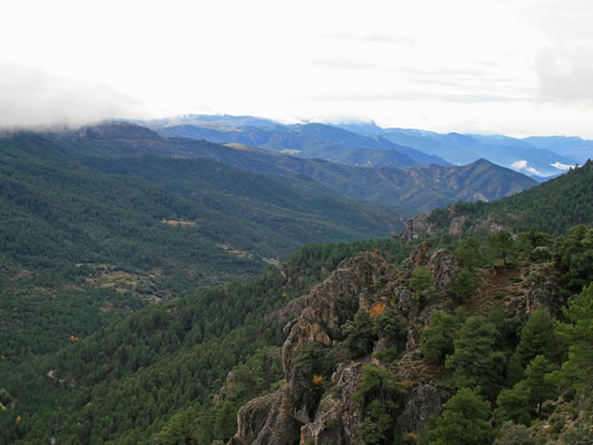
This stage begins with the beautiful asphalt forest track that climbs to the summit of El Yelmo, whose slopes it later abandons to pass those of its little brother, El Yelmo Chico. We will enjoy its peculiar rocky architecture, with powerful cliffs, cliffs and peaks of whimsical shapes. We will also contemplate from the slopes of this mountain some very wide and very complete panoramic views, since the route in this area is almost circular. We will see the El Tranco reservoir, the beautiful town of Hornos de Segura, the olive groves around Cortijos Nuevos, El Yelmo –which is the highest peak in the area– and the impressive wooded masses of the Hornos Gorge.
Starting from the charming village of La Capellanía, whose lavadero fountain overlooks the gorge from a privileged viewpoint, the route descends along the Arroyo de las Aceitunas, between Aleppo pin ...
This stage joins the beautiful black pine forests of Mount El Yelmo with the Historic-Artistic Complex of Hornos de Segura, allowing us to enjoy a delicious variety of environments, from the purely wooded to the most humanized ones.
This stage begins with the beautiful asphalt forest track that climbs to the summit of El Yelmo, whose slopes it later abandons to pass those of its little brother, El Yelmo Chico. We will enjoy its peculiar rocky architecture, with powerful cliffs, cliffs and peaks of whimsical shapes. We will also contemplate from the slopes of this mountain some very wide and very complete panoramic views, since the route in this area is almost circular. We will see the El Tranco reservoir, the beautiful town of Hornos de Segura, the olive groves around Cortijos Nuevos, El Yelmo –which is the highest peak in the area– and the impressive wooded masses of the Hornos Gorge.
Starting from the charming village of La Capellanía, whose lavadero fountain overlooks the gorge from a privileged viewpoint, the route descends along the Arroyo de las Aceitunas, between Aleppo pine forests and old abandoned orchards, to finally climb to Hornos de Segura via a mosaic of pine groves and small mountain olive groves. This small town is perched on a rocky platform and crowned by an old Arab castle, restored as a planetarium and astronomical interpretation center. It is worth strolling through the narrow streets of Hornos and its surroundings, contemplating the waters of the great El Tranco reservoir flanked by high mountains.
The entire area is very conducive to the observation of raptors, including the golden eagle, and large mammals such as the mountain goat and the wild boar.
Technical information
Route Name Rutas Bosques GR247
Rutas Bosques GR247 3: Refugio Casa Forestal de El Campillo - Hornos de SeguraHUSO 30S
Refugio C.F. El Campillo: x530647 y4233365
Hornos de Segura: x524905 y4230027
Refugio C.F. El Campillo: x530535 y4233157
Hornos de Segura: x524793 y4229820
TOTAL DISTANCE (IN KILOMETERS)16340
Asphalt or cement section 11,75 %
Section of track or forest road or promenade 43,02 %
Senda section 45,23 %
tramos-de-Vía-pecuaria 0%
ESTIMATED RUN TIMEO
5 h 25 minMAXIMUM SLOPE644 m
DIFFICULTY. ASSESSMENT ACCORDING TO METHOD MEASURE
2
MEDIO.
Severity of the natural environment
2
Itinerary
Orientation in the itinerary
2
Displacement
Difficulty moving
3
EFFORT.
Amount of effort required
TOTAL DISTANCE (IN KILOMETERS) 19540 M
Start
The Casa Forestal El Campillo Refuge is accessed from the JF-7016 from Segura de la Sierra or from the intersection with the A-317.
Final
Hornos de Segura can also be reached from the A-317.
INTERMEDIATE POINTS
PLACE
POSITION
TYPE OF ROAD
Km 11,35
Highway
CYCLABILITY
Steep slopes in short sections of trail between El Yelmo and El Yelmo Chico, and the first section of trail when leaving La Capellanía.
WATER POINTS
Fuente del Avellanar (near the Trail), Fuente de Los Ganados (near the Trail), watering holes before La Capellanía, La Capellanía village, Hornos de Segura.
PREFRESHING POINTS
On the trail: Hornos de Segura
Near the trail: Cortijos Nuevos, Segura de la Sierra
LINKS WITH OTHER TRAILS
PR-A 194; PR-A 147; PR-A 148; PR-A 150
Rutómetro
Campillo Forest House Refuge
The place where this stage begins, at an altitude of 1440 meters, has great scenic beauty and is at the foot of the road. This forest house had a notable importance in the past, as shown by its size and the various auxiliary buildings it has. In one of them is, precisely, the refuge that has been enabled for the Bosques del Sur trail. The area is dominated by black pine forests and green meadows, the poplars adding their yellow color in autumn.
The place is strategic for hiking. On the one hand, it is the beginning or end of stages 2 and 3 of the Bosques del Sur trail. But it also connects with two other signposted routes. Upwards, with the ascent to the summit of El Yelmo by derivation 2, and downwards, with a path marked by the Segura Hydrographic Confederation that leads to the Madera River. You can also go down to the Madera River from the junction of stage 2 with the GR 247.1 variant of the Bosques del Sur trail, an option that is a bit longer. In any case, the marked paths in the Segura de la Sier ...
Campillo Forest House Refuge
The place where this stage begins, at an altitude of 1440 meters, has great scenic beauty and is at the foot of the road. This forest house had a notable importance in the past, as shown by its size and the various auxiliary buildings it has. In one of them is, precisely, the refuge that has been enabled for the Bosques del Sur trail. The area is dominated by black pine forests and green meadows, the poplars adding their yellow color in autumn.
The place is strategic for hiking. On the one hand, it is the beginning or end of stages 2 and 3 of the Bosques del Sur trail. But it also connects with two other signposted routes. Upwards, with the ascent to the summit of El Yelmo by derivation 2, and downwards, with a path marked by the Segura Hydrographic Confederation that leads to the Madera River. You can also go down to the Madera River from the junction of stage 2 with the GR 247.1 variant of the Bosques del Sur trail, an option that is a bit longer. In any case, the marked paths in the Segura de la Sierra-Río Madera-El Campillo triangle allow hikers to tailor different highly attractive circular routes.
Our route begins along a paved forest track, in a gentle ascent in the middle of a large pine forest with an abundance of hawthorn trees. Immediately we leave the start of the path that goes up to El Yelmo on the right. Holm oaks and some gall oaks join the vegetal procession as we advance, and great views appear to the left, towards the Hornos Gorge, which is a narrow, deep and densely wooded valley. The distant Sierra de Cazorla closes the perspective in the background.
Path to the Yelmo Chico
We come to a fork. Towards the right we would climb to the summit of El Yelmo in 4 kilometers. To the left, the track descends towards the village of El Ojuelo, which is 10 kilometers away, very close to Cortijos Nuevos. We take this way and after a few meters we turn left again onto a path. But first, we must not stop looking at the natural viewpoint that constitutes the small cliff that we have just to our left, whose wide panoramic views will impress us.
Once on the aforementioned path, we will see that it widens and falls at first quickly. It is an old traditional path that runs between rocks and pine trees and that will allow us to reach the younger brother of El Yelmo, called El Yelmo Chico, which is actually the extension of the El Yelmo mass to the southwest.
The Small Helm
The path leads to the track that surrounds a good part of this mountain, joining our route to PR-A 150. We continue to the left. If we took to the right, we would cut off, but at the cost of giving up all the attractions that the El Yelmo Chico is going to bring us. The views that open towards the Hornos Gorge are great, and we will be able to enjoy them for many stretches over the next few kilometers, always surrounded by a forest of black pine dotted with some maples. The track goes around El Yelmo Chico in a clockwise direction.
Later this turn is more pronounced, appearing before our eyes the El Tranco reservoir, the Sierra de Las Villas on the other side of the Guadalquivir Valley, and the Cazorla reservoir in the background. A little further on we will also see the town of Cortijos Nuevos and the outer alignments of the Sierra de Segura, with villages on its slopes such as Arroyo Frío, El Pelón and Catena, in the middle of a large landscape mosaic of olive groves, pine forests and farmhouses. Behind these eleva ...
The Small Helm
The path leads to the track that surrounds a good part of this mountain, joining our route to PR-A 150. We continue to the left. If we took to the right, we would cut off, but at the cost of giving up all the attractions that the El Yelmo Chico is going to bring us. The views that open towards the Hornos Gorge are great, and we will be able to enjoy them for many stretches over the next few kilometers, always surrounded by a forest of black pine dotted with some maples. The track goes around El Yelmo Chico in a clockwise direction.
Later this turn is more pronounced, appearing before our eyes the El Tranco reservoir, the Sierra de Las Villas on the other side of the Guadalquivir Valley, and the Cazorla reservoir in the background. A little further on we will also see the town of Cortijos Nuevos and the outer alignments of the Sierra de Segura, with villages on its slopes such as Arroyo Frío, El Pelón and Catena, in the middle of a large landscape mosaic of olive groves, pine forests and farmhouses. Behind these elevations you can see the beautiful town of Chiclana de Segura, in the El Condado region, and in the background, the distant plains of La Mancha.
The slope on which we travel is oriented towards the northwest, which makes it easier for more maples to appear. To our right we see large vertical walls, and we find a small spring whose water is collected by an old wooden screw next to a maple. It is not uncommon, in all these places, to see groups of mountain goats.
At kilometer 7 we come to a crossroads. If we went to the right, we would return to the point where the path from which we descended from El Yelmo joined the track we are traveling on, always along the PR-A 150, through which a circular route can therefore be made around El Yelmo Chico. Our route, however, turns left here, heading towards the village of La Capellanía.
Crossing with track to the Fuente de los Ganados
At this point our route turns to the left again. If we took to the right we would go along the PR-A 147 to the old forest house of Fuente de los Ganados, a very pleasant place, with a fountain (although it is not certain that it has water), where we would arrive in about fifteen or twenty minutes and that constitutes an advisable detour if we are on time. Our stage continues around El Yelmo Chico on the same face that we have been walking along the last stretch, but now in the opposite direction and at a lower level, making a great zigzag. About 300 meters beyond this junction there is a path to the right, steeply descending, which would take us along the PR-A 147 to the village of El Robledo in about an hour and a half. Our route continues along the track and we enter a beautiful area of ??holm oaks with numerous maples and strawberry trees, flanked by spectacular rocky architecture with large vertical cliffs crowned with very striking contours. Here the pines are black rather than black, s ...
Crossing with track to the Fuente de los Ganados
At this point our route turns to the left again. If we took to the right we would go along the PR-A 147 to the old forest house of Fuente de los Ganados, a very pleasant place, with a fountain (although it is not certain that it has water), where we would arrive in about fifteen or twenty minutes and that constitutes an advisable detour if we are on time. Our stage continues around El Yelmo Chico on the same face that we have been walking along the last stretch, but now in the opposite direction and at a lower level, making a great zigzag. About 300 meters beyond this junction there is a path to the right, steeply descending, which would take us along the PR-A 147 to the village of El Robledo in about an hour and a half. Our route continues along the track and we enter a beautiful area of ??holm oaks with numerous maples and strawberry trees, flanked by spectacular rocky architecture with large vertical cliffs crowned with very striking contours. Here the pines are black rather than black, since, despite being at a lower altitude, the north orientation of this section creates cooler climate conditions that allow the appearance of these pines below the bioclimatic strip of the black, at reverse than usual. We will pass by a spring with another wooden tornajo, this one larger than the previous one, which creates a cool corner with abundant vegetation linked to humidity.
Soon, deep horizons will open up to us again towards Cortijos Nuevos, Hornos de Segura and the Sierras de Las Villas and Cazorla, and at kilometer 11.1 we leave the track taking a small path that leaves to the right and that cuts to reach La Chaplaincy.
The Chaplaincy
We arrive at this small and charming village, which is an important milestone in this stage and where it is worth stopping for a while to enjoy its atmosphere of a secure mountain village. It is inhabited throughout the year by a few people, and the building of the small school - now inactive - still preserves its era, and its laundry room. It is essential to approach the latter by a path of about 150 meters that leaves to the left of the village, and that constitutes a corner that we will not forget, with its fountain, its basins where it used to be washed by hand, the restored roof and an extraordinary lookout.
We leave the village passing in front of the old school gate, we begin to go down and after a few meters we leave the road to take a path that goes to the right, to the contrary. We descend rapidly between Aleppo pines, junipers and rosemary towards the bottom of the ravine of the Arroyo de las Aceitunas, also called La Garganta.
Arroyo de las Aceitunas ravine
The route reaches the bottom of the aforementioned ravine, which can usually be waded without problems because it carries little water, but if necessary, you can turn left and in a few meters we cross the river over a bridge. Then the path rises and the stream is below to our right, its waters falling in small cascades when there is sufficient flow. We go through some already abandoned terraces, where we must be attentive to the signaling beacons. The area is shady and the vegetation heterogeneous, because to the species typical of the Mediterranean forest that grow under the Aleppo pines, such as mastic and cornicabra, are added some typical of places with humidity, such as ash trees and some common rowan, to which they add trees that were cultivated at the time and are already abandoned, such as olive, fig and walnut trees.
After a well-signposted crossing, the path turns into a well-defined path. In the dense Aleppo pine forest there are some gall oaks and guillomos (Amelanchier ovalis). The road g ...
Arroyo de las Aceitunas ravine
The route reaches the bottom of the aforementioned ravine, which can usually be waded without problems because it carries little water, but if necessary, you can turn left and in a few meters we cross the river over a bridge. Then the path rises and the stream is below to our right, its waters falling in small cascades when there is sufficient flow. We go through some already abandoned terraces, where we must be attentive to the signaling beacons. The area is shady and the vegetation heterogeneous, because to the species typical of the Mediterranean forest that grow under the Aleppo pines, such as mastic and cornicabra, are added some typical of places with humidity, such as ash trees and some common rowan, to which they add trees that were cultivated at the time and are already abandoned, such as olive, fig and walnut trees.
After a well-signposted crossing, the path turns into a well-defined path. In the dense Aleppo pine forest there are some gall oaks and guillomos (Amelanchier ovalis). The road goes on a water pipe. It hardly has a slope and is very pleasant, opening to the right windows between the trees where we can contemplate the spectacular poyos of El Yelmo Chico where we come from.
When crossing a small olive grove, the path widens, to become a path again, which in some points is quite aerial and has the traditional dry stone blocks. We will pass through another somewhat larger olive grove that is worth looking at. It is the typical mountain olive grove of this area of ??the Sierra de Segura, with old twisted trunks and stone walls that spread out the ground to alleviate erosion. The place is extraordinarily expressive of the historical use of natural resources in this area of ??the natural park, since olive trees were planted on slopes with steep slopes in times when their cultivation was important for survival, despite their low productivity and laborious of its exploitation. Surrounded by Mediterranean forest and rocky formations, they make up a harmonious landscape, of which villages and farmhouses are also sometimes part, as we can well see from this same path when we look away towards the wide valley of Cortijos Nuevos. Today, the production of these mountain olive groves is still short, but the quality of their oils is extraordinary, both for the characteristics of the soil and the climate and for the careful preparation, subject to the regulations of the Denomination of Origin (EVOO) Sierra of Segura.
At kilometer 15.4 our path leads to a wide forest track that must be taken to the left, enjoying wonderful panoramic views of the aforementioned Cortijos Nuevos valley. Soon our eyes will be surprised by the vision of the town of Hornos de Segura, crowned by its castle.
Segura ovens
We arrived at this small mountain town from its upper part. Once in the center, in addition to calmly walking through its narrow streets, we must contemplate the great views that can be seen from two points, thanks to the elevated situation of the population, whose origin is defensive. The first is the viewpoint of El Aguilón, which is accessed from the square, where the parish church is also. It is literally a balcony from which we will see the relaxing waters of the El Tranco reservoir, which cover the old plain of Hornos, and the great mountainous elevations that flank it. The other viewpoint is on the opposite side of the town and is the Puerta de la Villa, of possible Almohad origin, which is the typical elbow entrance door to control the fortified access to the town, with an internal staircase that leads to a charming Roof terrace with views towards Cortijos Nuevos.
It is essential to go up to the castle, of Arab origin and recently restored as an astronomical interpretation center, the Cosmolarium. You can also stroll to the small viewpoints that are at the various exits of the town and, in summer, cool off after the walk in the municipal swimming pool, small, familiar and with a privileged location.
Additional information
The dark times for the El Tranco reservoir
There has been some written testimony of the drama experienced by the people affected by the expropriations for the construction of the reservoir in the early 1940s. If this process is always painful, it was much more so in a few years in which democracy had just been demolished in Spain, so there were practically no legal or political instruments for citizens to defend their interests.
The following text belongs to the book "Submerged Memories, 1931 1941" (Editorial El Olivo, Úbeda, 1999), by Ángel Robles Rodríguez, born in the farmhouse of El Chorreón - next to the GR 247 - which was expropriated to the construction of the reservoir. “Around 1940, what we had been dreading for so long came: they told us that we had to immediately evict and tear down the houses (...). Large crews of hackers and choppers entered with large axes cutting everything evenly, classifying the wood and burning the firewood and the thousands of hundred-year-old holm oaks that until then had covered the lands of La ...
The dark times for the El Tranco reservoir
There has been some written testimony of the drama experienced by the people affected by the expropriations for the construction of the reservoir in the early 1940s. If this process is always painful, it was much more so in a few years in which democracy had just been demolished in Spain, so there were practically no legal or political instruments for citizens to defend their interests.
The following text belongs to the book "Submerged Memories, 1931 1941" (Editorial El Olivo, Úbeda, 1999), by Ángel Robles Rodríguez, born in the farmhouse of El Chorreón - next to the GR 247 - which was expropriated to the construction of the reservoir. “Around 1940, what we had been dreading for so long came: they told us that we had to immediately evict and tear down the houses (...). Large crews of hackers and choppers entered with large axes cutting everything evenly, classifying the wood and burning the firewood and the thousands of hundred-year-old holm oaks that until then had covered the lands of La Vega, which they later turned into charcoal. Those lands, in a short time, were left as if they had received an atomic bomb. We, like all those from La Vega, migrated from the place with all our belongings and animals. We changed lands, landscapes, customs, neighbors and many other things that have no name, but that were real and remained within each of those people. For all of us, that change was very hard, although each one of us suffered it in silence ».

Follow us #JaénParaísoInterior


