


Vía Verde de Linares
The sinuous descent from Linares to Guadalimar

TYPE OF TRAIL
Path
Difficulty
Easy
START POINT
By car: We recommend that you access the Vía Verde through the following entrances:
Access No. 1: From Linares (Barriada San Gonzalo), on Úbeda street.
GPS coordinates (decimal format): 38.095651 °, -3.622015 °.
Access No. 2: In Linares, crossroads between the Vía Verde and Calle Mar Menor.
GPS coordinates (decimal format): 38.096232 °, -3.618323 °.
Access No. 3: From the Camino de Arquillas (N-322, Linares-Baeza Station).
GPS coordinates (decimal format): 38.084612 °, -3.591498 °
By train:
Linares: Medium Distance, Madrid-Jaén Line and Renfe Long Distance
Connections:
Jaén: 30 Km
TOTAL DISTANCE (IN KILOMETERS)
6,60 Km
Type of firm
Compacted gravel.
DIFFICULTY. ASSESSMENT ACCORDING TO METHOD MEASURE
0
MEDIO.
Severity of the natural environment
0
Itinerary
Orientation in the itinerary
0
Displacement
Difficulty moving
0
EFFORT.
Amount of effort required
TYPE OF ACCESSIBILITY
It can be traveled on foot, by mountain bike and in a wheelchair
TYPE OF CARTOGRAPHY
Military Map of Spain. Scale 1: 50,000: Sheet 905. Official Road Map. Ministry of development.
TIME OF THE YEAR
All year
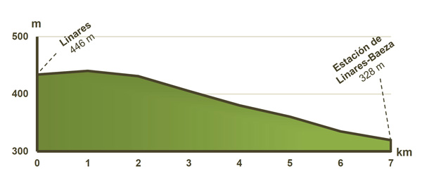
HEIGHT PROFILE
MUNICIPAL TERMS BY WHICH IT RUNS
Linares LinaresNATURAL ENVIRONMENT
Guadalimar Valley. Olive trees and riverbank vegetation
RECREATIONAL OR SPORTS AREAS NEAR THE TRAIL
4 rest areas, equipped with tables, benches, bike rack, wastebaskets and fountains
OTHER INFORMATION OF INTEREST (ARCHITECTURAL OR HISTORICAL-CULTURAL, GEOLOGICAL-ECOLOGICAL)
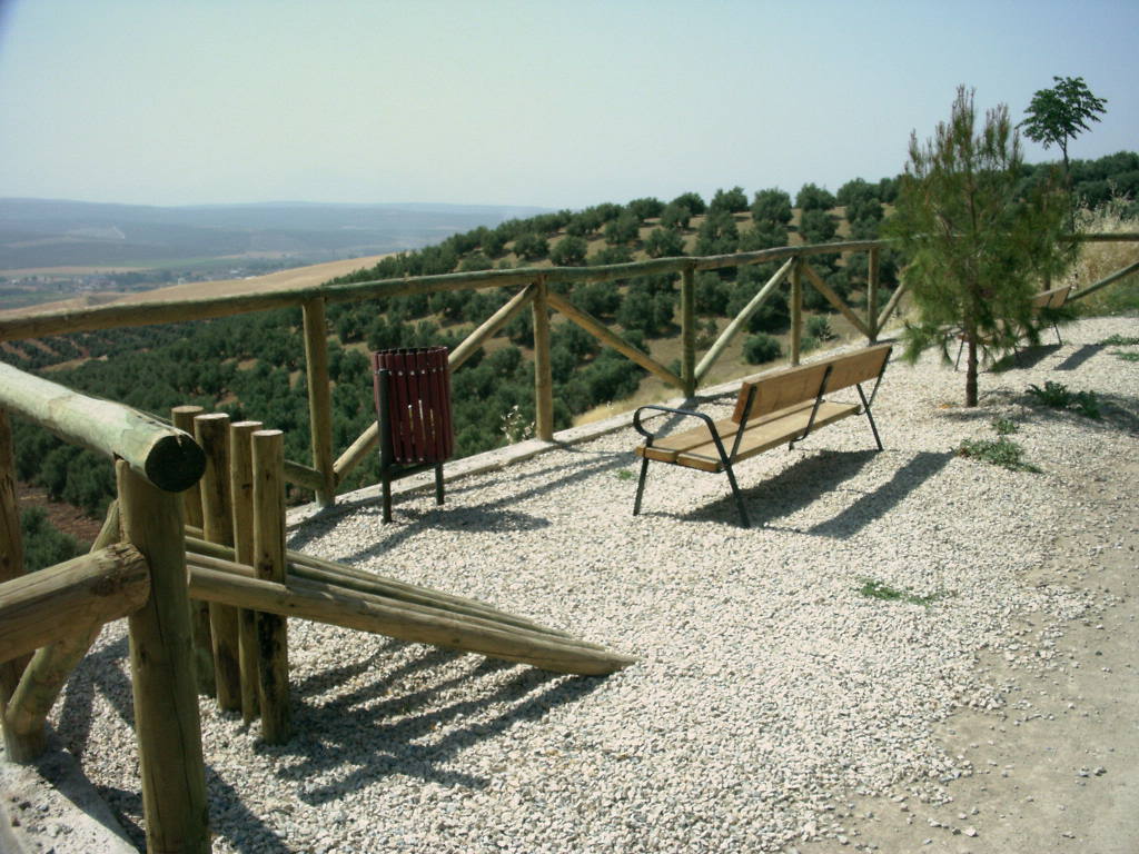
"Mirador del Valle", from where you can have a wide and beautiful view of the Guadalimar valley and various nearby towns,
POINTS OF INTEREST
This Greenway has 1 Protected Natural Area located in a radius of less than 5 km: The ZIC of the Guadalimar River (Natura 2000 Network).
DESCRIPTION
The Linares Greenway runs for 6 km, from the old Linares - San José Station, better known in the municipality as the "Almería Station", to the Linares - Baeza Station, corresponding to the old railway line between Linares and Almería.
The need and interest in this late railway was justified with the aim of bringing the new means of transport to the abandoned Eastern Andalusia, which until then, 50 years after the first Spanish railway, had been left out of the railway plans of the State.
The objective of the new railway company created around the railway from Linares to Almería, the Compañía de los Caminos de Hierro del Sur de España (South of Spain), was to make the transport of lead to the port of Almería more attractive due to the less mileage between the mining city and the port of Almería. The kilometers of track linking the Linares-Baeza Station with the Linares-San José Station were not completed until 1904. The mining crisis in this region caused this section to lose traffic, and trains stopped passing through its tracks in 1961.
Links of interest
Source of information
Follow us #JaénParaísoInterior


