


Trail the Straits of Miranda
The public use trail Los Estrechos de Miranda is the link between the Llano de las Américas Visitors Centre and other public use facilities in the Despeñaperros Natural Park; a trail that will allow us to enter the park without the need to travel by car.
This facility is designed to allow visitors who have just visited Llano de las Américas to go as far as the La Campana River (1.8 km away), and from there decide whether they want to go to the La Aliseda Recreational Area, managed by the Santa Elena Town Council, which has a long tradition in the area (1.3 km away), or to Miranda del Rey (1.6 km away), from where they can connect with either of the two public use trails that start from this district towards the heart of Despeñaperros.

TYPE OF TRAIL
Path
Difficulty
Low
START POINT
The trail starts next to the Llano de las Américas Visitors' Centre, on the right-hand side. To get to the visitor centre, take exit 257 of the A-4 as it passes through Despeñaperros, to connect with the JA-7102 road that links the centre of Santa Elena with the district of Miranda del Rey. The visitor centre is located at kilometre 2 of this road, on the left hand side. It has parking facilities for both cars and buses.
TOTAL DISTANCE (IN KILOMETERS)
4.700
ESTIMATED RUN TIME
1 hour and 30 minutes.
Type of firm
Track
DIFFICULTY. ASSESSMENT ACCORDING TO METHOD MEASURE
0
MEDIO.
Severity of the natural environment
0
Itinerary
Orientation in the itinerary
0
Displacement
Difficulty moving
0
EFFORT.
Amount of effort required
SIGNALING
Sí
MUNICIPAL TERMS BY WHICH IT RUNS
Santa Elena Comarca NorteRECOMMENDATIONS
- Compared to COVID19, keep a safe distance and wear a mask, avoid crowding and contact with surfaces, wash your hands frequently, use hydroalcoholic gel and consult the digital materials available. Take care of your health and that of others.
- Collaborate to avoid fires. Do not throw cigarettes or any other object that produces combustion.
- By consuming local products and having local businesses you will contribute to rural development.
- Live respectfully with the local people and other users. Respect private goods and properties.
- Travel in a sustainable way: public transport, cycling, walking, car sharing
- Noise is another form of pollution. In silence you will enjoy your experience more.
- Make it easy for people with special needs to use it.
- Trash does not come back alone. Take it with you to the nearest container. Reduce, reuse, recycle.
- Don't leave a trace of your passage through nature.
- Practice responsible tourism and be committed to the environment. Be a true ecotourist!
- Respect the facilities made available to you. We all pay for their maintenance.
- Consult the weather forecast before starting your activity.
- Avoid going out alone. If you do, inform other people of the route and time of return.
- Be extremely careful in adverse conditions and in the occasional presence of animals or motor vehicles.
- Find out beforehand if there is any hunting activity.
- Bring water, sun protection, suitable clothing and footwear.
- Carry a mobile phone with a sufficient battery in case of emergency (112), but remember that there is not always coverage.
- Do not disturb or feed the animals. You will negatively alter their behaviour.
- For your safety and that of the environment, do not leave the marked path or take shortcuts.
- Remember that it is forbidden to capture animals, light fires, fish and collect plants or minerals.
- If you bring a dog, keep it on a leash and make sure it does not disturb other animals or people.
- Your safety is our concern, but it is your responsibility.
Thank you for your cooperation!
DESCRIPTION
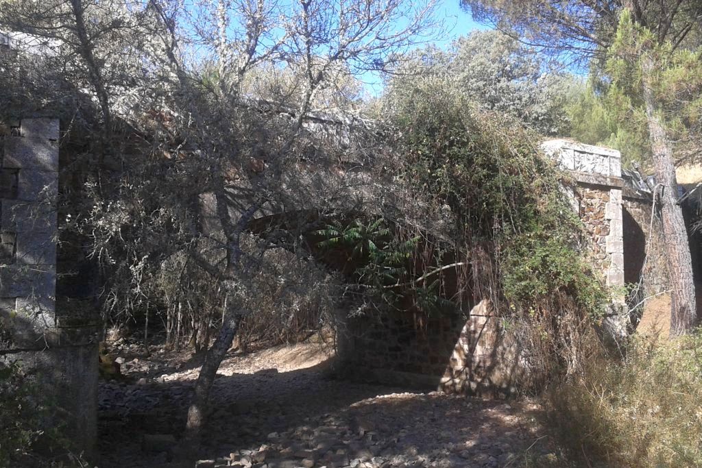
The first section of the path runs under the electricity line that supplies Miranda del Rey, which we leave 400 metres later to turn left, along the track that leads to the first obligatory stop: El Cortijo de las Américas. It is a vestige of other times when the population was entrenched in the rural environment, and despite the deteriorated state in which it finds itself, it still conserves its Moorish oven in perfect condition, an ethnographic element of vital importance in the past, since the population that lived in retreat from the centres of population depended on their own means to produce their food, and among them the most basic: bread.
From here we will begin to descend gently via a path to the river La Campana, through a mixed forest with magnificent examples of cork oak (Quercus suber) and holm oak (Quercus ilex), interspersed with pine trees for reforestation; as we are crossing the public mountain La Aliseda, one of those that were forcibly repopulated in the 60s.
One kilometre further on you will have reached the river, and you will be able to follow it upstream or downstream thanks to the path that runs parallel to it on the livestock track called "Vereda del Camino Empedrado o del Puerto del Rey". If we go down, that is, to the left, the riverbank vegetation (among which the tamujo, reeds and hawthorns stand out) will delight us for just over a kilometre until we reach a bridge that crosses it, the end of the path. On the other side of the bridge is the return point of the Sendero Río de La Campana, next to an exaggerated ash tree that forces you to take out your camera. From this point, the La Aliseda Recreational Area is just 500 metres away.
If you decide to go up the La Campana River, that is, continue to the right at the fork in the trail, the delicate sound of the water flowing and the incessant song of the countless birds that live along its banks will accompany you for a kilometre, until you start to separate from it by turning right and, 500 metres further on, you will reach the Miranda del Rey district. The crossroads we come to once again allows us to plan our visit at our leisure. If you turn right you can visit the village, which grew up around a post house and later became one of the characteristic colonisation villages of the time of Charles III. Although today most of the farmhouse is used as a holiday home, you can still see old houses from that period.
If we decide to turn left from the crossroads, we will start the Molino del Batán path, which will allow us to visit the westernmost part of the Despeñaperros Natural Park. Finally, if we continue straight ahead, we will begin the Empedraillo path, which will take us into the heart of the park, bringing us closer to this historic road that forms part of the so-called Camino Real.
Source of information
Follow us #JaénParaísoInterior


