


Sendero Barranco de Valdeazores
The Valdeazores stream has a short perpendicular path to the Despeñaperros gorge, where it empties. The path borders its entire basin, a ravine with regular shapes covered in one part by a rich and diverse Mediterranean forest, and in another by conifers introduced by afforestation. To the considerable natural values of the place are added others of a historical or cultural nature, related to the strategic nature of the gorge, of which we will have juicy views from a viewpoint located on it.

TYPE OF TRAIL
Rocky and stony
Difficulty
Media
START POINT
On the A-4 motorway, heading towards Cádiz, we will take the track that comes out to the right at km. 245.3, about two hundred meters from the sign indicating the entrance to Andalusia, which will take us -after traveling 300 m.- to the Valdeazores forest house, next to which the trail begins.
TOTAL DISTANCE (IN KILOMETERS)
12,8
ESTIMATED RUN TIME
5 hours 30 minutes
SLOPE
300
300
DIFFICULTY. ASSESSMENT ACCORDING TO METHOD MEASURE
1
MEDIO.
Severity of the natural environment
2
Itinerary
Orientation in the itinerary
2
Displacement
Difficulty moving
2
EFFORT.
Amount of effort required
SIGNALING
Sí
MUNICIPAL TERMS BY WHICH IT RUNS
Santa Elena Comarca NorteRECOMMENDATIONS
It is recommended to bring drinking water and suitable clothing and footwear. Make sure the drinking water from the sources. This trail can be done throughout the year. In summer, due to the special altitude conditions, the insolation is very strong and requires significant sun protection.
POINTS OF INTEREST
- Gorge and Despeñaperros pass.
- Arroyo de Valdeazores
- Ruins of the medieval Castle of Castro Ferral
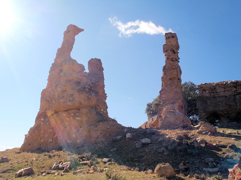
- Natural Monument of Los Órganos
DESCRIPTION
We will have to go to the Valdeazores forest house, which is accessed from the A-4 motorway, only in the Madrid-Cádiz direction, along a track that goes to the right at km 245.3, two hundred meters after passing the sign that indicates the entrance to Andalusia and just before the viewpoint of the Jardin de Despeñaperros. We will climb three hundred meters along this track until we reach a forest house, from whose parking lot the path starts.
We will go north, but soon we will head west, which is the one that we will maintain in the first half of the route towards the head of the Valdeazores stream, following at the beginning a water conduction. As in much of the journey, we will go up a gentle but continuous slope. We will see around us mixed forests that are the result of reforestation, in which pines abound in the suns, and cypresses in the shadows. The native vegetation is gaining ground with the height, remaining also in important patches of the slope on the other side of the stream -umbría- that have a humid Mediterranean forest with holm oaks, cork oaks, gall oaks, Pyrenean oaks or holly trees. On the shore there are gallery formations of alders and ash trees, dotted with willows, oleanders and tamujos.
When we have already walked about two and a half kilometers, we come to a chestnut grove where there is a spring that supplies the driving force that accompanied us. It is a good place to rest and enjoy the deciduous forest, gathering strength to continue the climb. One kilometer later, at the head of the stream, we will find the track that goes down from the Muladar port towards the Castro Ferral castle, which is approximately a kilometer and a half away. We can choose to approach this medieval fortress that protected the La Losa pass, definitively snatched from the Almohads by Christian armies in the framework of the battle of Las Navas de Tolosa. It is in ruins because it was later abandoned and destroyed to prevent its use by outlaws.
If we discard the variant of the castle along the track, we will only do about fifty meters, and we will leave it along a path that leaves it to the right in the direction of Collado de la Aviación, as indicated by the signs, completing a 180º turn that will set us on course to the east, walking on the crest of the right bank of the ravine. The humid Mediterranean mountain that we saw from the other side is below us, which now we find ourselves surrounded by pine trees again.
We will walk another two and a half kilometers to crown Los Órganos hill (natural monument), where the Collado de la Aviación refuge is located, a small aerial surveillance post from the Civil War, later used by shepherds and fire fighting devices. Continuing along the path that continues in the same direction we were going, we will cross a forest of pines, holm oaks, cork oaks and gall oaks, to come out to a clear rocky area where there is a small viewpoint with magnificent views of the Despeñaperros gorge, which is where it ends the path.
Source of information
Follow us #JaénParaísoInterior


