


Ruta del Aceite (Segunda jornada: de Las Casillas a Alcalá la Real)
Difficulty
high
TOTAL DISTANCE (IN KILOMETERS)
38 km
ESTIMATED RUN TIME
2 h. 30 min
SLOPE
805 m
805 m
DIFFICULTY. ASSESSMENT ACCORDING TO METHOD MEASURE
0
MEDIO.
Severity of the natural environment
0
Itinerary
Orientation in the itinerary
0
Displacement
Difficulty moving
0
EFFORT.
Amount of effort required
SIGNALING
Sí
MUNICIPAL TERMS BY WHICH IT RUNS
Alcalá la Real Sierra SurRECOMMENDATIONS
The stage, although a bit long, is very varied. It has an asphalt asphalt, followed by a descent and then comes a practically flat section that ends in a steep climb. In times of rain, certain difficulties may arise when having to wade through the Guadalcotón stream four times.
DESCRIPTION
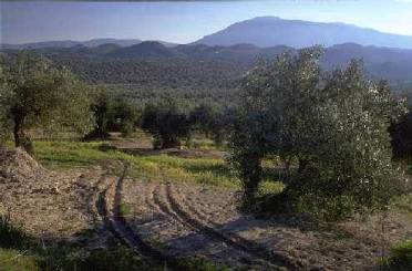
The first part of the day runs along the road that leads from Vado del Fresno to the Sierra Ahillos. The route leaves the asphalt road before the pass, past kilometer 16 (km 9.3). The dirt track follows a cattle track, the Fuente Mateo stream in Martos. Numerous crossroads and forks emerge, but none of them offer any doubt as they are signposted. At first there are constant ups and downs, but soon the definitive descent to the Ventas del Carrizal begins. Then you pass next to the Baños farmhouse (km. 13.9), famous for the sulphurous waters that flowed there. Further on, a mountain known as Encina Hermosa is surrounded, where there are remains of an important Iberian-Roman enclosure. Shortly before reaching the fertile plain, the lane that approaches one of the watchtowers that adorn the area is left on the right. Just before the bridge over the San Juan river, the itinerary turns to the left and, for several kilometers, it runs along the river plain, along with the route of the Caliphate of the Andalusian Legacy. At the foot of Castillo de Locubín, the route deviates (km. 23.1) to continue along the right bank of the river. After a short stretch by road, take the direction of El Nacimiento, where a handful of springs feed the entire valley with water. After the recreational area, the path fits between the Guadalcotón cliffs, and after repeated wading, the ascent to Charilla begins. Once the urban area is forced, the route deviates to the left along a lane (km. 34) that borders the cliffs of Loma de San Marcos, ending at the gates of Alcalá la Real. During the two centuries that the Christian siege of the Nasrid kingdom lasted, these borderlands served as a platform for harassment and skirmishes. Fortresses were built in the towns, and on their strategic hills a whole chain of watchtowers or simple watchtowers that, as an advance guard, watched over the enemy's movements. Along the wide plain watered by the San Juan River there are up to 4 towers; although some miraculously whole, all preserve the calm serenity of someone who has seen centuries of history pass. Whoever dares to get close to his feet will have the opportunity to look over the same horizons, now covered with olive trees.
Follow us #JaénParaísoInterior


