


Ruta de la Sierra (De Frailes a Valdepeñas de Jaén)
The Valdepeñas-Frailes stage, belonging to our Long Distance Trail of the Sierra Sur de Jaén, begins its journey in the Chorrillo Park. After a brief stretch through urban land, we arrive at one of the natural exits of the town on the way to Frailes.
Difficulty
Low
TOTAL DISTANCE (IN KILOMETERS)
15 km
ESTIMATED RUN TIME
2 hours
SLOPE
350 m
350 m
DIFFICULTY. ASSESSMENT ACCORDING TO METHOD MEASURE
0
MEDIO.
Severity of the natural environment
0
Itinerary
Orientation in the itinerary
0
Displacement
Difficulty moving
0
EFFORT.
Amount of effort required
SIGNALING
Sí
MUNICIPAL TERMS BY WHICH IT RUNS
Frailes Valdepeñas de Jaén Sierra SurRECOMMENDATIONS
The difficulty of the route lies more than anything in the four hills that behave like true "leg breakers", although half of the route runs on asphalt. Any time is good to visit these places, in summer it will be necessary to leave early to avoid pedaling in the hours of greatest sunshine. Water is not lacking.
DESCRIPTION
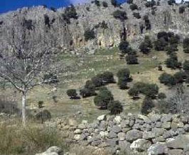
The route crosses Frailes in its lower part. Once out of the town, a fork appears (km. 1.9). Both roads lead to Valdepeñas de Jaén but the one on the right will be chosen. The first few meters pass through the river valley, then the gentle pedaling ends and the first climb must be faced, with some quite steep ramps. Once you have left the Los Rosales farmhouses, you will reach the first hill (km. 5.5). At this point you have to continue straight ahead and ignore them two paths on the right, to descend without loss to a stream that is forded. The route gains height again to the Cortijos de Cerezo Gordo. Immediately and after a short descent, the next ascent begins which, despite being long, does not present the hard previous slopes. At the beginning of the slope (km. 11.2) we pass the zigzagging lane that leads to Noalejo on the right. The asphalt ends next to a ruined farmhouse. Shortly afterwards, you will arrive at Puerto Pinatero (km. 13.2), located at the foot of Los Nevazos peak, the vertex of the Sierra del Trigo. The route continues straight on along the widest path and, as it loses height, it discovers the beautiful valley where the La Fresnedilla farmhouse is located. After having crossed the fourth hill, one goes down to the basin of the Carboneros, enclosed between impressive cliffs. Its meadows and stream invite you to rest before the last climb. Almost 200 meters must be saved, but once they are overcome, a rapid descent awaits that ends in Valdepeñas de Jaén. The tormented orography of the Sierra Sur has slowed down the widespread invasion of agriculture and in its interior there are hardly any population centers beyond some lonely dying farmhouses. On the other hand, the natural environment has managed to remain in an almost wild state. In fact, the Mediterranean forest and scrub cover 30% of the surface and grazing is still the essential activity.A secular cattle trail goes deep into the mountain range and travels its most remote corners in a rugged journey to the meeting of places still unknown.
Follow us #JaénParaísoInterior


