


Path to the Cueva de los Muñecos
The culture of the Iberians holds many mysteries that may never be explained. Their beliefs are almost unknown, but it is not surprising that they had one of their main places of worship in these areas, and even more so that it was appropriated by the Romans to satisfy their gods.

Difficulty
Halb
START POINT
The path begins at the Historical and Cultural Heritage Interpretation Centre, which can be reached by the A-6.200 road that, coming from the A-4 motorway (exit at km 250, towards Cádiz), leads to Aldeaquemada.
TOTAL DISTANCE (IN KILOMETERS)
3,2
ESTIMATED RUN TIME
1 hour 42 minutes.
Type of firm
Spur
SLOPE
150 m
150 m
DIFFICULTY. ASSESSMENT ACCORDING TO METHOD MEASURE
2
MEDIO.
Severity of the natural environment
2
Itinerary
Orientation in the itinerary
2
Displacement
Difficulty moving
1
EFFORT.
Amount of effort required
TIME OF THE YEAR
All year round
SIGNALING
Sí
MUNICIPAL TERMS BY WHICH IT RUNS
Aldeaquemada Comarca NorteRECOMMENDATIONS
It is recommended that you bring drinking water and appropriate clothing and footwear. Make sure that the water in the fountains is drinkable. This trail can be done all year round. In summer, due to the special conditions of altitude, the sunshine is very strong and requires significant sun protection. Be careful with the steep slopes of the last section and the pools of archaeological excavations.
POINTS OF INTEREST
- Interpretation Centre for the Historical and Cultural Heritage of the Despeñaperros Natural Park
- Cueva de los Muñecos, which dates back to the 6th century BC and is considered one of the oldest extra-urban Iberian sanctuaries, and also one of those that had a certain territorial control character.
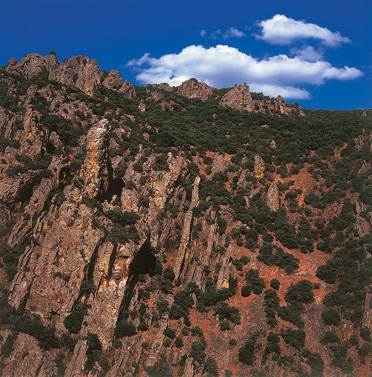
- Cerro del Castillo, at 961 m. altitude, ancient Iberian settlement.
- The Organs.
DESCRIPTION
The path starts at the Historical and Cultural Heritage Interpretation Centre in the Despeñaperros Natural Park (see map), which can be reached by taking the A-6.200 road from the E-05 motorway, towards Aldeaquemada. The centre has been built on an old sheepfold at the foot of the Castle hill. On the opposite side of the hill, the Autovía del Sur runs through the historic Despeñaperros pass.
However, on this side where we find the intense traffic of the highway seems far away. A visit to the centre is certainly recommended, as it provides information on the natural and cultural heritage of the surroundings and also of this path. Around the centre we can see places of great ecological significance. On the shady slopes, facing north, we will see wooded formations with deciduous trees, such as gall oak, and bushes such as durillos or madroños. On the other hand, on the sunny side, the mountain is dominated by holm oak groves with little underbrush, made up of Pyrenees, rockroses, rosemary, etc.
The path consists of two sections of about five hundred metres each, both starting from the interpretation centre. One goes up the hill of the Castle -to the west- and the other goes down to the cave of Los Muñecos, to the southwest. Although the order in which you go through them is indifferent, since in any case you have to return to the interpretation centre, we will assume that you will first undertake the climb to the hill. The winding path that we will take runs through a relatively leafy holm oak forest that disappears around the 920 metre level. Then, up to the top of the hill, at 961 m, we will see more bare rock than vegetation.
On the top are the remains of a possible Iberian settlement and a viewpoint over the gorge with breathtaking views, with Santa Elena to the south and the Muradal pass to the plateau. Opposite, the impressive stone structure of the Los Órganos hill and, below us, the motorway that follows the route that was opened with great difficulty at the end of the 18th century, as an alternative to the Las Ventas road (via Los Pedroches) and other routes in use between the ports of Cadiz and Seville - ports of America - and the capital of the kingdom.
After going back to the interpretation centre, we will head towards our second destination, the cave of Los Muñecos. We will go down a gentle slope on the slope of the Cerro del Castillo, and parallel to the power line, towards the road we arrived on. We will cross the lower part of the same holm oak tree that we already knew when we climbed the hill, where we will also see cork oaks and large junipers.
In two hundred and fifty metres we will reach a point very close to the road, where we will change direction to go around the gorge we see on our right, in whose surroundings we will be able to distinguish Montpellier maples and abundant cornicabras. Be careful with some of the slopes and pools from the many excavations carried out here, as you are in a rich area of archaeological sites, with the cave of Los Muñecos as the centre of these, where the path ends.
Source of information
Follow us #JaénParaísoInterior


