


Embalse de Las Anchuricas

This small reservoir, nestled between dense pine forests and high mountains, is a delightful surprise for the visitor, because its level is usually kept high and it really looks like a narrow lake. It collects the waters of the Segura River once it leaves the town of La Toba and extends for 4 - 5 km to its dam. Depending on the sunlight of the moment, its waters can have different shades, from an intense blue to an emerald green, which adds more mystery to those it already has hidden ...
And it is that under its waters the old village of Las Casicas is flooded. The dam that gave rise to the reservoir was completed in 1957 to supply water to the Miller hydroelectric plant, and upon receiving water from the Segura, the village became another refuge for the trout and barbel that swim in its waters.
As a faithful witness to the presence of the village has remained its church, a simple rectangular construction, damaged by the passage of time, which looms serenely over the waters of the reservoir on top of a mound surrounded by holm oaks, hawthorns and rockrose.
It is common to see griffon vultures flying over the reservoir. The mountains that surround it offer refuge to these raptors, and they are also a spectacular viewpoint of its waters. The views from the Puntal de la Misa, the Umbría de los Anguijones or from the Majalón peak are possibly the most spectacular in this area.
Technical information
Route Name Rutas Bosques GR247
Rutas Bosques GR247 7: Embalse de Las AnchuricasHUSO 30S
Nacimiento de la Toba: x538810 y4226331
Presa de las Anchuricas: x541280 y4228815
Nacimiento de la Toba: x538698 y4226124
Presa de las Anchuricas: x541169 y4238608
TOTAL DISTANCE (IN KILOMETERS)5700
Asphalt or cement section 0 %
Section of track or forest road or promenade 100 %
Senda section 0 %
tramos-de-Vía-pecuaria 0 %
ESTIMATED RUN TIMEO
2 h 3 minMAXIMUM SLOPE167 m
DIFFICULTY. ASSESSMENT ACCORDING TO METHOD MEASURE
1
MEDIO.
Severity of the natural environment
1
Itinerary
Orientation in the itinerary
1
Displacement
Difficulty moving
2
EFFORT.
Amount of effort required
Rutómetro
Birth of the Toba
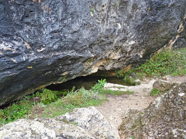
The start of this diversion is located at the La Toba water source, a very visited place, which is accessed from the village by walking along the stream that runs through it. Leaving the last houses, we stroll through lush vegetation around the water and the garden area that surrounds us. Between watercress and walnut trees, we come to a limestone wall where the cave that gives rise to this mighty upwelling is located.
Starting from the water tank, we must follow the narrow track that has taken us there from the village, to find a few meters away the threshing grounds for cereal, always located in the most strategic places to take advantage of the air currents necessary to the winnowing process. The path runs through a shady area, at a certain height above the reservoir, among a lush forest of black pine or salgareño, dotted with boxwood, holm oaks, junipers, junipers and maples.
In the initial part of the route, the old terraces, on which the inhabitants of these lands cultivated, now in disuse, with lots ...
Birth of the Toba
The start of this diversion is located at the La Toba water source, a very visited place, which is accessed from the village by walking along the stream that runs through it. Leaving the last houses, we stroll through lush vegetation around the water and the garden area that surrounds us. Between watercress and walnut trees, we come to a limestone wall where the cave that gives rise to this mighty upwelling is located.
Starting from the water tank, we must follow the narrow track that has taken us there from the village, to find a few meters away the threshing grounds for cereal, always located in the most strategic places to take advantage of the air currents necessary to the winnowing process. The path runs through a shady area, at a certain height above the reservoir, among a lush forest of black pine or salgareño, dotted with boxwood, holm oaks, junipers, junipers and maples.
In the initial part of the route, the old terraces, on which the inhabitants of these lands cultivated, now in disuse, with lots of walnut trees and other fruit trees that cover the landscape with color in the autumn months, attract attention.
At 500 meters from the start, we pass some walnut trees with a small fountain. Below us, on the banks of the reservoir, we see the small church of Las Casicas, a vestige of the primitive village that was relocated somewhat higher in the valley when the dam was built. Up at the top, we will be struck by the Puntal de la Misa, the Cuerda del Mosco and Poyo Alto, and below them, the Los Barranquillos or Fontarrón farmhouses stand out among the green forests.
Collado Hermoso
The track runs winding and with little unevenness, so the walk is calm and pleasant among abundant aromatic plants. In a small esplanade the magnificent view that has given its name to this place opens up to us. From this point the track begins to descend to leave the Anchuricas dam on the left and under it.
Anchuricas Dam
We come to a ford over the Segura River, surrounded by wicker and poplars. On the left, the reservoir dam, built in 1957, for mainly hydroelectric purposes, rises above us. At this point the end of this path is located, since fording the river entails a certain danger since there may be increases in flow without prior notice, as indicated by the existing signs.

Follow us #JaénParaísoInterior


