


Refugio Casa Forestal del Campillo - Cumbre del Yelmo

Due to its altitude and its central location in the Sierra de Segura, El Yelmo is an emblematic mountain in the popular culture of this region, as well as being a national and international point of reference in the world of free flight.
The route is mostly along a narrow and sometimes quite steep path, which was formerly used by the horsemen and has been renovated to form part of the Southern Bosques Trail.
This path is a magnificent alternative to reach the summit of El Yelmo avoiding its forest track, which was paved a few years ago to facilitate access to the free flight takeoff enabled at the summit. We will walk through black pine forests, through holm oaks and through mixed forests of both species, the gall oak being abundant in the first half of the way. From time to time, we will see beautiful maples and hawthorn trees. Above 1600 meters of altitude the broom appears, dotted by the scarce and twisted larices that resist the harsh conditions of cold, snow, insolation and wind of the high mountains.
The views that we gain as we ascend are among the best that we can ...
Due to its altitude and its central location in the Sierra de Segura, El Yelmo is an emblematic mountain in the popular culture of this region, as well as being a national and international point of reference in the world of free flight.
The route is mostly along a narrow and sometimes quite steep path, which was formerly used by the horsemen and has been renovated to form part of the Southern Bosques Trail.
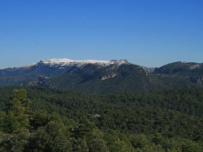
This path is a magnificent alternative to reach the summit of El Yelmo avoiding its forest track, which was paved a few years ago to facilitate access to the free flight takeoff enabled at the summit. We will walk through black pine forests, through holm oaks and through mixed forests of both species, the gall oak being abundant in the first half of the way. From time to time, we will see beautiful maples and hawthorn trees. Above 1600 meters of altitude the broom appears, dotted by the scarce and twisted larices that resist the harsh conditions of cold, snow, insolation and wind of the high mountains.
The views that we gain as we ascend are among the best that we can obtain in the Natural Park, since we can see the immense forests of the whole protected area, the distant peaks of Albacete and Granada and the plains of La Mancha.
In the harmonious set of forests and olive groves in the lowlands, the beautiful towns of Hornos de Segura and Segura de la Sierra stand out from a bird's eye view, as well as the waters of the El Tranco reservoir. The forest guardhouse on the summit, in whose surroundings it is possible to see groups of mountain goats, is an exceptional viewpoint that we will hardly forget.
Technical information
Route Name Rutas Bosques GR247
Rutas Bosques GR247 2: Refugio Casa Forestal del Campillo - Cumbre del YelmoHUSO 30S
Refugio C.F. El Campillo: x530654 y4233358
Cumbre de El Yelmo: x530010 y4234292
Refugio C.F. El Campillo: x530541 y4233151
Cumbre de El Yelmo: x529898 y4234085
TOTAL DISTANCE (IN KILOMETERS)3150
Asphalt or cement section 6,35%
Section of track or forest road or promenade 0 %
Senda section 93,65%
tramos-de-Vía-pecuaria 0 %
ESTIMATED RUN TIMEO
1 h 36 minMAXIMUM SLOPE348
DIFFICULTY. ASSESSMENT ACCORDING TO METHOD MEASURE
1
MEDIO.
Severity of the natural environment
1
Itinerary
Orientation in the itinerary
2
Displacement
Difficulty moving
2
EFFORT.
Amount of effort required
Rutómetro
Campillo Forest House Refuge
We leave the paved track next to the Casa Forestal and leave it after a few meters to take the wide path that comes out to the right.
We walked through a black pine forest dotted with gall pines, seeing El Yelmo in front. The beacons of this route are colored white and yellow, because although it is included in the Bosques del Sur Trail, it coincides in its entirety with the PR-A 194. Shortly afterwards we find a fork that we take to the right, showing holm oaks and some maples .
At 750 meters from the beginning, we take the small traditional path that goes up to the summit to the right, opening to the left magnificent views that anticipate those that we will enjoy from the summit. The path winds between larices and holm oaks, gaining height as well as panoramic views, to reach a hill with two old and twisted gall oaks in which there are extraordinary views towards the other slope, which are lost in the plains of La Mancha.
Helm Track
At this point the path reaches the Yelmo asphalt track, which we travel for about 100 meters to resume our path to the left, paying attention to the mark that indicates it. Soon we will find again and leave the track to continue along the twisted path, already through rocky and bare terrain.
Helm Summit
We reached the summit of Yelmo, which although it has numerous telecommunications infrastructures, is the peak of the entire northern area of the Natural Park that offers the best views: the Cortijos Nuevos valley and its villages to the west, and beyond, the plains of La Mancha from Ciudad Real; to the south, the great Tranco reservoir, the high mountains of the Sierras de Las Villas, Cazorla and El Pozo, as well as the peak of La Sagra, already in Granada, which touches an altitude of 2400 meters; and to the east the north, the numerous curtains that make up the calares of the Sierra de Segura, split by the valleys of the Madera and Segura rivers, and the Calar del Mundo, in the province of Albacete.

Follow us #JaénParaísoInterior


