


The landscapes of the GR 247 Bosques del Sur trail
The GR 247 Bosques del Sur Trail runs through an overwhelming extension of mountainous and wild territories where the scarce human footprint is integrated into the landscape, and where you can also enjoy the familiar and welcoming atmosphere of its white villages, the transparency of its rivers and streams and its gentle olive groves. In the Sierras crossed by the Path, the bright blue of the Mediterranean skies, the white of the snow on the peaks and the green of the largest forest mass in Spain merge. This wonderful combination of light, high mountains, large forests and small villages is not found anywhere else in Spain.
An abrupt and powerful relief
Through the GR 247 Bosques del Sur Trail you will discover one of the most important mountain ranges in the Iberian Peninsula. Most of the villages are situated between 700 and 1000 metres above sea level. More than half of the Park's surface area is between 1000 and 1500 metres, but there are peaks that rise above 2000 metres, such as Cabañas peak (2028 metres), Alto de la Cabrilla (2039 metres) and Empanadas peak (2107 metres), which is the highest point in the Park. On average, more than fifty peaks exceed 1600 metres.
This complex is arranged in abrupt alignments in a north-east- south-west direction, which sometimes intersect and are usually separated by deep valleys carved by the rivers, flanked by steep rocky escarpments.
The eastern part of the Natural Park is the most mountainous part. In the northeast area you can find many calares, which are elongated mountains that rise up on all four sides and ...
An abrupt and powerful relief
Through the GR 247 Bosques del Sur Trail you will discover one of the most important mountain ranges in the Iberian Peninsula. Most of the villages are situated between 700 and 1000 metres above sea level. More than half of the Park's surface area is between 1000 and 1500 metres, but there are peaks that rise above 2000 metres, such as Cabañas peak (2028 metres), Alto de la Cabrilla (2039 metres) and Empanadas peak (2107 metres), which is the highest point in the Park. On average, more than fifty peaks exceed 1600 metres.
This complex is arranged in abrupt alignments in a north-east- south-west direction, which sometimes intersect and are usually separated by deep valleys carved by the rivers, flanked by steep rocky escarpments.
The eastern part of the Natural Park is the most mountainous part. In the northeast area you can find many calares, which are elongated mountains that rise up on all four sides and are crowned by extensive plains. Continuing southwards, you will find one of the most original and unexpected landscapes of the Park: the great high plateau of Los Campos de Hernán Perea, at 1600-1700 metres of altitude. Further south, always in the eastern area, you will see the Empanadas and Cabrilla mountains, where the Park is more rugged and reaches its highest levels, with some ten peaks exceeding 2000 metres.
In the western part of the Park, the mountains begin in the north with moderate altitudes and simple profiles in the Calderón, Oruña and Cumbres de Beas mountain ranges, always below 1350 metres. To the south of these, in the Sierra de Las Villas, there is a complex and intricate relief, with peaks rising up on steep slopes above 1800 m.
At the southern end of the Natural Park, an impressive set of mountains rises decisively over the olive-growing countryside of Jaén and the sub-desert areas of Huesa and Hinojares (where the lowest point in the Park is at 470 metres). These are the Sierras de Cazorla and El Pozo, which reach their peak at Cabañas (2026 metres).
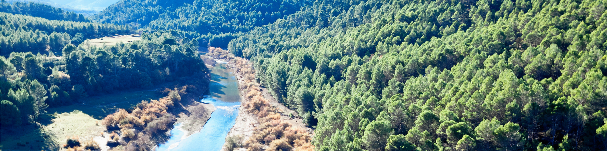
Many of these mountain ranges are separated by rivers which have carved out the landscape with deep rifts in the form of canyons, gorges, ravines, gullies and enclosed valleys which are undoubtedly one of the most unique landscape features of the Park.
Among the valleys, the Guadalquivir stands out. The beautiful corridor between mountains that opens up this river in a northeasterly direction continues, beyond the Tranco reservoir, into a wide intramountain depression covered by olive groves, which is drained by the Guadalimar River and flanked to the west by the Yelmo, one of the Park's most emblematic peaks because of its altitude (1808 metres) and because it is a famous free flight station. Other rivers have dug numerous valleys in the mountains, sometimes wild, sometimes more tame, but always attractive for the charm and harmony of the scenery they form.
Natural architectures
Walking along the GR 247, you will be surprised by the suggestive forms that many of the rocky formations of these Sierras show. The rocks, being limestone, do not react uniformly to the action of water, but their different parts offer unequal resistance, forming capricious profiles and natural architectures typical of the karst landscape. The picones, which are large needle-shaped or tower-shaped rocks, the molas and castellones, vertical rocks with flat summits, and the poyos, colossal stone blocks with horizontal contours that crown some mountains, are all impressive.
Other very characteristic formations are the tufas, beautiful lime plates that sediment under water in waterfalls and oozing walls. The rocky soils are sometimes densely carved by water, forming labyrinthine networks of cracks, crevices and depressions. These are the lapiaces, known in these mountains as lanchares. Sometimes the stone slabs are very steep ...
Natural architectures
Walking along the GR 247, you will be surprised by the suggestive forms that many of the rocky formations of these Sierras show. The rocks, being limestone, do not react uniformly to the action of water, but their different parts offer unequal resistance, forming capricious profiles and natural architectures typical of the karst landscape. The picones, which are large needle-shaped or tower-shaped rocks, the molas and castellones, vertical rocks with flat summits, and the poyos, colossal stone blocks with horizontal contours that crown some mountains, are all impressive.
Other very characteristic formations are the tufas, beautiful lime plates that sediment under water in waterfalls and oozing walls. The rocky soils are sometimes densely carved by water, forming labyrinthine networks of cracks, crevices and depressions. These are the lapiaces, known in these mountains as lanchares. Sometimes the stone slabs are very steep, so the action of the water is less noticeable. In these regions they are called lastras.
You can also find, in high areas, the surprising torcos or dolinas. These are collapses in the ground, with rounded contours and a funnel shape. Their bottom acts as a sinkhole for rainwater, which is why they are called sorbores in these mountain ranges and usually have continuity in the form of deep chasms.
On the flanks of the rock formations there are large rocky areas, here called cascajares, formed by the accumulation of stones that have been falling down the slope after the fragmentation of the rock located in the upper part of the mountain. Some plants are adapted to live in this hostile environment, because although their external appearance is very discreet, they have an extensive root system and their stems are easily renewed even if they are cut by the movement of the stones.
The vegetal landscape
Above all, this Natural Park is an immense pine forest. But, as can be seen along the Bosques del Sur path, it is a varied, diverse pine forest, where pines of different species and sizes blend harmoniously with many other trees and shrubs. Here you can hardly find those monotonous pine plantations that seem to be cloned, like columns over bare soils.
The three pine forests...
As you ascend the path, you will see Aleppo, Black and Corsican pines. Of the latter, the Natural Park is proud to have the best forests in Spain. With their straight trunks of whitish bark, these large pines are the masters of the landscape in the higher areas. Even higher up, the peaks are the space of the rock and the great panoramas.
Below the wide strip of pine forest, the landscape has been harmoniously humanised by the establishment of olive groves with an intense mountain personality, as they climb to the limit where this cul ...
The vegetal landscape
Above all, this Natural Park is an immense pine forest. But, as can be seen along the Bosques del Sur path, it is a varied, diverse pine forest, where pines of different species and sizes blend harmoniously with many other trees and shrubs. Here you can hardly find those monotonous pine plantations that seem to be cloned, like columns over bare soils.
The three pine forests...
As you ascend the path, you will see Aleppo, Black and Corsican pines. Of the latter, the Natural Park is proud to have the best forests in Spain. With their straight trunks of whitish bark, these large pines are the masters of the landscape in the higher areas. Even higher up, the peaks are the space of the rock and the great panoramas.
Below the wide strip of pine forest, the landscape has been harmoniously humanised by the establishment of olive groves with an intense mountain personality, as they climb to the limit where this cultivation is possible.
But in addition to olive groves, pine forests and panoramic peaks, Spain's largest protected area holds many surprises. Here there are very different combinations of altitude and orientation, which produce many nuances in the plant landscape.
The protective shade of the pine forest shelters dense undergrowth, which in turn is a hive of animal life. The pine groves located up to an altitude of 1000-1100 metres, which are those of Aleppo Pine (Pinus halepensis), are rich in rosemary and various rockroses on dry and sunny slopes, while in more favourable situations a bushy stratum develops with species typical of other formations that preceded the current pine groves. For example, we find the kermes oak (Quercus coccifera), the mastic tree (Pistacia lentiscus), the labyrinth or olive tree (Phillyrea angustifolia) and the durillo (Viburnum tinus).
The strip of land with the black pine (Pinus pinaster) (also called resinous and rhododenum) is situated between 1000 and 1300 metres above sea level. It is home to junipers (Juniperus oxycedrus), whose hard roots were used to make the large balls used in the popular game of mountain bowling, and cornicabras (Pistacia terebinthus), whose leaves turn intensely crimson in autumn. This bush, here called cornice, owes its name to the curious shape of the gills it develops in response to the bite of certain aphids.
Further up, in the band dominated by the laricio or salgareño pine (Pinus nigra ssp. salzmanii), the forest is rich in wild roses, of which the Park has thirteen different species, which in spring and summer offer their five-petal flowers whose colours range from white to various shades of pink. Its ovate red fruits, known as rosehips, have been eaten since ancient times by humans because of their strong astringent properties.
Another very abundant bush in this area is the hawthorn (Crataegus monogyna), which in spring is completely covered with white flowers that perfume the whole environment with a very sweet aroma, and in autumn it offers you its spherical red fruits -the majoletos- which are perfectly edible when they are very ripe.
From 1600-1700 metres onwards, and sometimes from further down depending on local conditions, you will find the area of peaks and limestone, where the climate plays rough and only the piornos and small plants adapted to the wind, snow and strong thermal contrasts survive. It is the kingdom of the rock and the great panoramic views, which the Bosques del Sur path allows you to discover in various points, all of them very unique.
There, the natural elements can be seen in all their purity because, precisely because of the roughness of their environment, their ecosystems have been preserved in a more natural state than in the middle and lower areas.
... and much more
But, although the pine woods make up the majority of the landscape, diversity is one of the signs of identity of the GR 247. Therefore, many other trees and bushes will attract your attention. Sometimes they are mixed with the pines and other times they become protagonists of the landscape as formations with their own personality.
Walking along the Bosques del Sur path, the hiker will find oaks (Quercus faginea) that form forests. Some old specimens have a majestic appearance that is a symbol of the fertile past of these mountains, when the oak trees occupied a larger area than today. The walker will also see holm oak and even juniper woods (Juniperus phoenicia). You will discover the Pyrenean oak groves (Quercus pyrenaica), so rare in the southeast, with their beautiful lobed leaves. Also strawberry trees, dotted with red and orange in autumn.
Scattered here and there, you will find maples, both the so-called Granada maple (Acer granatensis) and the Montpellier maple (Acer monspessulanum), the latter being very rare in southern Spain and both having a sensational autumn colouring.
The human footprint
If there is one thing that characterises the largest protected natural area in Spain, it is the discreet imprint that man has left on its landscape over the centuries. But that trace is there, almost always for the better.
The olive grove
Most of the human footprint inside the Natural Park can be seen in the northern area, that is, in the region of Segura. In the lower parts the GR 247 crosses olive groves that climb the slopes, with numerous patches of forest and bushes interspersed. The olive grove is the basis of the economy of the Park and its extensive area of influence, and a key element of its landscape, its culture and the daily life of its people. In reality, it is a cleared forest which, although artificial and lacking the structure and diversity of natural forests, constitutes an agrosystem complex where many species of plants and animals are present
The mountain pastures
In a large part o ...
The human footprint
If there is one thing that characterises the largest protected natural area in Spain, it is the discreet imprint that man has left on its landscape over the centuries. But that trace is there, almost always for the better.
The olive grove
Most of the human footprint inside the Natural Park can be seen in the northern area, that is, in the region of Segura. In the lower parts the GR 247 crosses olive groves that climb the slopes, with numerous patches of forest and bushes interspersed. The olive grove is the basis of the economy of the Park and its extensive area of influence, and a key element of its landscape, its culture and the daily life of its people. In reality, it is a cleared forest which, although artificial and lacking the structure and diversity of natural forests, constitutes an agrosystem complex where many species of plants and animals are present
The mountain pastures
In a large part of the high areas of the Segura region, the path runs through areas where the human footprint manifests itself in a totally different way: it is the livestock landscape. These are areas that have historically been deforested to open up pastures for Segureño sheep. The landscape is sometimes overwhelming due to the width of its panoramic views, always flanked by high elevations and dotted with patches of scrub and rocky formations. In winter it is the territory of snow. In spring, it is the land of green high grasses. And always, the home of an ancestral cattle culture that deserves the greatest recognition.
The villages and farmhouses
One of the most gratifying attractions of the Bosques del Sur Trail is its passage through small villages where you can breathe in an atmosphere that seems anchored in another time. Apart from the larger villages, the profusion of isolated villages and small farms is another feature that gives the Natural Park a marked personality, especially in the part corresponding to the Sierra de Segura. In the higher areas, many of these human enclaves are no longer populated, or are populated only during the months of more benign weather. The traditional architecture of the villages is unevenly preserved, but the presence of these nuclei is not only aesthetically pleasing, but also moving as a testimony to a way of life that has historically been hard and has been able to adapt masterfully to the difficult conditions of the mountains.
The orchards
Where the route passes by towns and villages the walker will see small vegetable gardens, called hortales. They are located in the strikes, as here the few more or less flat and fertile lands located by the river and the stream are called. Mountain farming in these mountains has always been purely subsistence, so many of these vegetable gardens have suffered the same fate as the villages and farmhouses to which they were linked: abandonment. But in the lower areas near the villages many vegetable gardens are still active, producing exquisite vegetables. Each strike, even if it is already abandoned, is a small landscape wonder that brings diversity to the whole in which it is integrated. Its balance is most relaxing, as it reconciles the wise gardening touch of the human hand -terraces, pools, walnuts, poplars...- with the grandeur of the surrounding mountains, which are always nearby.
The reservoirs
The abundance of water in the Natural Park has led to the construction of reservoirs of very different sizes and capacities. Walking along the GR 247 Bosques del Sur footpath you will discover three of them, those of Anchuricas, El Tranco and La Bolera. Surrounded by high mountains, all of them are a heritage of great economic and scenic importance, as well as very quiet places where only the force of the wind or the oars are allowed to navigate


