


Cycling route: Gil Cobo Recreational Area - Llanos de Jabalcaballo
Coming from Chilluévar, continue past the Aguascebas reservoir for about 8 km and then turn right at km 28 onto a secondary forest track or path where the road crosses a stream known as Aguascebas de Gil Cobo. This is where the route starts. You can also arrive at the starting point if you are coming from Charco del Aceite.

NAME OF THE TRAIL
Campamento de Gil Cobo a Cortijos del Pardal
TYPE OF TRAIL
Circular
START POINT
If it is accessed from Chilluévar and about 8 km after passing the Aguascebas reservoir, at km 28, there is a secondary forest track or path that leaves to the right of the road, just where the road crosses the Arroyo de las Aguascebas de Gil Cobo, start of the route. But we can also access the start from the Charco del Aceite.
HEIGHT
1178 m
ARRIVAL POINT
ITINERARY.
GIL COBO- CERRADA DE SAN GINES- LANCHA DE LA ESCALERA- LLANOS DE JABALCABALLO- CORTIJO DEL PARDAL
HEIGHT
1178 m
TOTAL DISTANCE (IN KILOMETERS)
11300 (one way)
Asphalt or cement section % of the total %
Section of track or forest road or promenade % of total 100%
Senda section % of the total %
Sections of livestock track. Green way % of the total %
Type of firm
Sandy and rocky
SLOPE
476 m
279 m
DIFFICULTY. ASSESSMENT ACCORDING TO METHOD MEASURE
0
MEDIO.
Severity of the natural environment
0
Itinerary
Orientation in the itinerary
0
Displacement
Difficulty moving
0
EFFORT.
Amount of effort required
TYPE OF CARTOGRAPHY
Topographic maps of ANDALUCÍA DE IGN (1: 25.000): SHEET 21
PASSAGE PLACES (IN ORDER TO THE DIRECTION OF TRAVEL)
Inicio- Gil Cobo
30S x=509107 y=4214671
1288
Cerrada de San Ginés
30S x=509642 y=4214119
1365
Junta de los Arroyos
30S x=509787 y=4214016
1341
Fuente Colorá
30S x=509268 y=4213487
1445
Tiná Serbal
30S x=509215 y=4213988
1440
Poyo de los Robles
30S x=508515 y=4213706
1574
Arroyo de la Fuente del Tejo
30S x=508280 y=4212323
1443
A Cortijos de la Cañá del Avellano
30S x=507833 y=4211202
1425
Cortijos la Berraza y manantial
30S x=508211 y=4210948
1415
Cortijo el Pardal
30S x=508418 y=4209450
1474
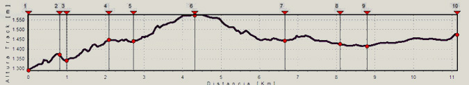
HEIGHT PROFILE
MUNICIPAL TERMS BY WHICH IT RUNS
Villacarrillo La Loma y Las VillasDESCRIPTION
The trail begins in the Gil-Cobos Recreational Area and Camp on the right bank of the Aguascebas stream, going up the secondary forest track that exists there in a southeast direction. 800 m from the beginning we find one of the most beautiful places on this route, the Cerrada de San Ginés, a vertical encirclement of rocky cliffs formed by the Lanchas del Lobo on the left and the Lancha de la Escalera on the right, It is surrounded by deciduous forests, pine forests, and riparian and rupicolous communities.
At the end of it, where the stream divides in two, the track also divides and we must turn right according to the direction of travel, to continue a steep climb in its first meters; After a steep curve we find a work fountain with some stone tables, it is Fuente Colorá, 2.1 km from the beginning. 600 meters further on we find on our left a tinda, it is Majalserbal, which stands on the beautiful and wild Lancha Ignacio. The other boat, which falls from the tinada towards the beginning of the Cerrada de San Ginés, is called Lancha del Sordo.
After 4.4 km we come to a hill. We are at the top of the Lancha de la Escalera (Torcales de la Lancha de la Escalera). The Poyo de los Robles is what all this land is also called. Great panoramic views of the Úbeda hill with several well-visible villages and the Sierra Mágina massif. We are close to 1600 m of altitude and the vegetation is characteristic of the high mountains of the Park, broom trees and other small plants, shrubs and thorns, as well as sand plants, black pines and some holm oaks.
This area will be the highest of our route, since from here we begin to descend. The track traces several curves with a firm formed of loose stones and quite bumpy until it enters the flat lands of Jabalcaballo. Unique karst landscape that will accompany us until the end of our journey. We find several streams in its highest part, such as Arroyo del Raso de la Escalera and Arroyo de la Fuente del Tejo, and at km 6.7 and also a reed with water called the Fuentecilla de los Buitres.
Further on, at km 8.2, we leave a track to the left, which leads to other farmhouses in Cañá del Avellano or farmhouses in Jabalcaballo as well. We will continue to the left to find the Cortijos de la Berraza at km 8.8, where there is a fountain. From this moment on, the road becomes more difficult and it begins to turn to the right to leave Peña Corba on our left.
At 11.3 km we reach the Cortijos del Pardal. It is advisable to ascend the peak on foot since, with its 1,578 m, it offers a wide panoramic view of the area. We will return by the same way out.
Follow us #JaénParaísoInterior


