


Refugio C.F. Hoya de los Trevejiles- ZAC Fuente de los Cerezos

It is a stage that takes place in low areas of the natural park, between 550 and 950 meters of altitude, in which we must highlight the steepness of the territory, the breadth of views throughout the route and the botanical and fauna wealth of the area . Part of the Hoya de Los Trevejiles forest house, which is one of the best in the natural park due to its location, conservation and architecture. We will descend to the deepest part of the Guadalquivir river valley, we will visit the Charco del Aceite Recreational Area, with an exceptional bathing area of ??crystal clear and cold waters, and we will cross the Puente de los Agustines, one of the few accesses to the Sierra de las Villas. Between pine forests, mountain olive groves, walnut trees, strawberry trees, lentiscares, holm oaks and kermes oak groves, the path will take us out onto the natural balcony of the Ermita de la Hoz, contemplating extensive olive groves towards Iznatoraf, the Picos del Guijarrón (or Quijarón) and the Cumbres de Beas, the Poyo de Andaragasca and the Lancha del Tosero.
The verticality of the limestone walls im ...
It is a stage that takes place in low areas of the natural park, between 550 and 950 meters of altitude, in which we must highlight the steepness of the territory, the breadth of views throughout the route and the botanical and fauna wealth of the area . Part of the Hoya de Los Trevejiles forest house, which is one of the best in the natural park due to its location, conservation and architecture. We will descend to the deepest part of the Guadalquivir river valley, we will visit the Charco del Aceite Recreational Area, with an exceptional bathing area of ??crystal clear and cold waters, and we will cross the Puente de los Agustines, one of the few accesses to the Sierra de las Villas. Between pine forests, mountain olive groves, walnut trees, strawberry trees, lentiscares, holm oaks and kermes oak groves, the path will take us out onto the natural balcony of the Ermita de la Hoz, contemplating extensive olive groves towards Iznatoraf, the Picos del Guijarrón (or Quijarón) and the Cumbres de Beas, the Poyo de Andaragasca and the Lancha del Tosero.
The verticality of the limestone walls impose a sinuous route on us, the great griffon vultures will continuously watch our steps from the sky, while the deer, wild boar and mountain goats will surprise us in some of the most beautiful corners of this territory. And we will immerse ourselves in the ancestral way of life maintained by the few inhabitants of these mountains, who have struggled for centuries to gain ground from the mountains to be able to grow olive trees, fruit trees, vegetables and cereals.
Technical information
Route Name Rutas Bosques GR247
Rutas Bosques GR247 6: Refugio C.F. Hoya de los Trevejiles- ZAC Fuente de los CerezosHUSO 30S
C.F. Hoya de los Trevejiles: x515603 y4226787
ZAC Fuente de los Cerezos: x513403 y4224044
C.F. Hoya de los Trevejiles: x515491 y4226580
ZAC Fuente de los Cerezos: x513291 y4223837
TOTAL DISTANCE (IN KILOMETERS)14660
Asphalt or cement section 17,05 %
Section of track or forest road or promenade 63,17 %
Senda section 19,78 %
tramos-de-Vía-pecuaria 0%
ESTIMATED RUN TIMEO
4 h 44 minMAXIMUM SLOPE415 m
DIFFICULTY. ASSESSMENT ACCORDING TO METHOD MEASURE
2
MEDIO.
Severity of the natural environment
2
Itinerary
Orientation in the itinerary
2
Displacement
Difficulty moving
3
EFFORT.
Amount of effort required
TOTAL DISTANCE (IN KILOMETERS) 19540 M
Start
The Hoya de los Trevejiles Forest House is accessed by a short paved forest track from the A-6202 road, which connects Villanueva del Arzobispo with the Tranco Dam.
Final
The Fuente de Los Cerezos Controlled Camping Area is accessed, both from Villanueva del Arzobispo and from El Tranco, by the A-6202 road and then by the Las Villas JH-7155 road, at the beginning passing through the Oil Charco .
INTERMEDIATE POINTS
PLACE
POSITION
TYPE OF ROAD
Km 9,6
Forest track
CYCLABILITY
Steep slopes on sections of the path between Fuente Negra and El Charco del Aceite, as well as between La Loma de la Be and the Cortijo de Los Estrechos de la Hoz.
WATER POINTS
Hoya de los Trevejiles Forest House, Charco del Aceite Recreational Area, Ermita de la Hoz, Controlled Camping Area Fuente de los Cerezos
PREFRESHING POINTS
On the trail: There is no
Rutómetro
Hoya de los Trevejiles Forest House
Our tour starts from the Hoya de los Trevejiles forest house along the forest track heading southeast. Just 300 meters away we come out onto a narrow paved track, where we must turn left downhill. To the right are several houses belonging to this small nucleus. On this descent we are entering a very deep river valley with a strong landscape character, dominated by Aleppo pines.
Highway A-6202
We come out onto the A-6202 road that connects El Tranco with Villanueva del Arzobispo. We will go to the right, and after 800 meters we must turn to the left. At the entrance to this new track there are signs indicating access to Fuente Negra. Access is via a very narrow and asphalted track, with a steeper descent, and soon we will leave the small houses that make up this tourist town on both sides. When you reach the lowest area, there is a larger building and here the track ends.
Low Houses of Fuente Negra
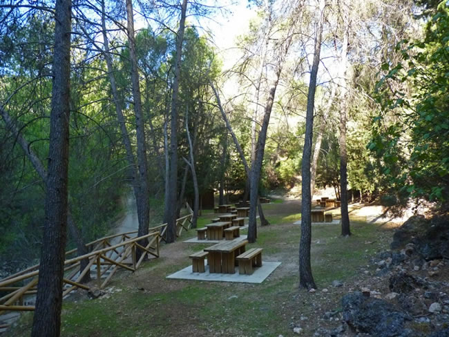
Upon reaching the large building, we take a wide path to the right that runs parallel to the Guadalquivir river on its right bank. After almost a kilometer we arrive at the Charco del Aceite Recreational Area, which is an area with a lot of shade given the boxing of the river at this height. The Aleppo pine begins to share its habitat with many other species, which make up a dense and diverse forest.
Charco del Aceite Recreational Area
This area is on our left and is well worth a good stop. The Guadalquivir's water is still and it is a perfect place to take a bath in summer or to enjoy a magnificent day the rest of the year. The area has tables and a kiosk-bar. The place is very embedded, so it is very leafy, and is framed by pine forests that descend from the steep rocky slopes that surround it. In its fresh crystalline waters inhabit the queen of the park's rivers, the audacious common trout, as well as barbel and river bogas.
On a large rock, which juts into the middle of the river, an exceptional viewpoint is striking, giving us a magnificent view of this unique place, whose waters reflect the intense green of the vegetation. According to tradition, the name of this place is due to the fact that, on one occasion, a donkey loaded with oil skins rushed down the narrow path that was then, falling into this puddle and staining it with the contents of its load.
Augustines Bridge
We leave by the track that accesses the recreational area and we come out onto the JH-7155 road at the height of Venta de los Agustines, made up of some small buildings on the left of which the bridge of the same name crosses the Guadalquivir river. At this point, in summer and taking advantage of the El Tranco water discharges, it is common to observe the descent of the river in rafting and open kayaking carried out by some active tourism companies in the area, which have this enclave as their starting point.
On the other side of the bridge, we find a mural where the roads of the area are represented, and their most important places. Barely 50 meters further on, to the right, a dirt track starts along which we enter to cross the Arroyo María, and continue parallel to the Guadalquivir river, gradually gaining height.
Olive groves appear, which will intermittently accompany us during almost our entire journey until after the Hermitage of La Hoz. They are mountain olive trees, with very steep slopes. Wild boars, deer and mountain goats are very common, as shown by the abundance of their tracks, and that we can easily observe if we go in silence.
The track soon begins to twist and turn, twisting on the slope it ascends as the panoramas begin to get wider and wider.
Track cut
In the middle of the climb, at an altitude of 700 meters and, when the presence of olive groves becomes intermittent, the track is cut by a barrage of detached earth. Here begins a wide path, with loose stone, that just in 800 meters leads back to an olive track. To the right we see a wide panoramic view of the Guadalquivir Valley. On the other side we see some large warehouses that correspond to the Sierra de Cazorla Water Bottling Plant (located in the Las Villas region) and further on, also to the right, when our track begins to turn south, we will contemplate at a height the town of Iznatoraf.
Track
The vegetation becomes more diverse, the first black pines appear and we avoid numerous vertical walls, full of griffon vulture vultures.
Above 950 meters of altitude, the track we are traveling on turns to the right uphill, and we must continue along the path that appears in front, at first leveling, but soon descending. This path takes us into a magnificent forest, where pine is the most striking tree due to its size, but it is not the dominant species. The forests that from this moment on we travel have a remarkable diversity of species of both flora and fauna.
Cortijo Los Estrechos de la Hoz
The path leads to a stone era traditionally used for threshing cereal, and we are surprised by a small farmhouse, which we must skirt, leaving it on our left, to get to the access trail. This farmhouse is still inhabited, like those that we will find later in the Ermita de la Hoz. It is important to be respectful with the inhabitants of the area and with their orchards, fruit trees, walnut trees, vines, etc. They are very friendly and communicative people who have stoically endured the depopulation that these mountains suffered during the last century.
Barely 200 meters from the farmhouse we pass a large walnut tree, at the foot of which there is an old laundry room. At this point you have to pay special attention, since you have to discard the road, which is busier, which turns to the right uphill, reaching the Cortijos de Casa de Cuadros. Our route, however, turns left. About 100 meters after this crossing we find a simple and inconsistent gate that we will have to open and close, to continue along the olive track that will soon take us to the Ermita de la Hoz.
Farmhouses Ermita de la Hoz
To our left we pass several farmhouses that make up this small nucleus, where apparently there was a hermitage that gave them their name. From here we will go through a track in good condition, ascending again, highlighting the wonderful views to the left, where we will always have the reference of Risca de Guijarrón (or Quijarón) and Cumbres de Beas, and even in some points La Hoya de los Trevejiles, place of departure.
Soon the olive trees disappear and we continue through this magnificent black pine forest, going uphill, leaving the Poyo de Andaragasca and the Lancha del Tosero on the left, very characteristic formations, in a landscape in which steep slopes and steep slopes predominate. That area was hit in 2005 by a fire, hence the particularly rugged aspect of the current landscape.
Approximately 1.5 kilometers from the Ermita de la Hoz we find a metal barrier, which we must cross without further ado. Soon we come out onto the paved road, where we must turn left.
Controlled Camping Area Cherry Tree Fountain
On the road and continuing uphill, we will walk approximately 400 meters, leaving the Cortijo de Arroyo Martín on the right, to finally reach the source that gives its name to this Controlled Camping Area, which has good facilities for organized groups.
Additional information
The tree herders
This stage crosses the Guadalquivir river, which for centuries was not only the main artery of Andalusian agriculture, but also a true highway where millions of logs were transported, giving way to the forest wealth of these mountains to Seville and other cities. The mountains that today are part of the park always had a strong forest use due to the quality of their black pine or salgareño pine (Pinus nigra ssp. Salzmanii) forests. Before modern means of transport and communication existed, the wood left these mountains through the rivers.
The wooden river pipes were strongly promoted during the 18th century, when these forests attracted the interest of builders and shipowners, as suppliers of raw materials for civil construction and shipbuilding. The woods went down the Guadalimar and Guadalquivir rivers towards Seville and through the Segura towards Cartagena. In the nineteenth century there were timber that exceeded one million pieces transported, but in the middle of the twentieth century this transport system ...
The tree herders
This stage crosses the Guadalquivir river, which for centuries was not only the main artery of Andalusian agriculture, but also a true highway where millions of logs were transported, giving way to the forest wealth of these mountains to Seville and other cities. The mountains that today are part of the park always had a strong forest use due to the quality of their black pine or salgareño pine (Pinus nigra ssp. Salzmanii) forests. Before modern means of transport and communication existed, the wood left these mountains through the rivers.
The wooden river pipes were strongly promoted during the 18th century, when these forests attracted the interest of builders and shipowners, as suppliers of raw materials for civil construction and shipbuilding. The woods went down the Guadalimar and Guadalquivir rivers towards Seville and through the Segura towards Cartagena. In the nineteenth century there were timber that exceeded one million pieces transported, but in the middle of the twentieth century this transport system became obsolete due to the introduction of road transport.
These woods could last several months and moved important contingents of pine downriver, accompanied by an entire quartermaster operation made up of hateros or guisanderos, messengers (who carried the daily food rations, called errands), guards, shopkeepers and payers. The pineros led the logs and sleepers with a long pole whose end was inserted into an iron hook with two ends, one straight and the other curved inward. That is why they were also called gancheros. His trade was dangerous and required great skill and sacrifice.
The conduction was very hierarchical. At the head was the river master, under whose command were the mayorales, responsible for two to four groups or companies. Each of these consisted of twelve to twenty men commanded by a squad. The front crews opened the conduction by marinating the river, that is, preparing it to facilitate the passage of wood in the most rugged places of the river or in the sections where it was dry, by means of dams, ramps and soles, which were channels made with the same logs.
The crews in the rear had to undo these works by reincorporating the wood used to drive, as well as freeing the logs caught in the river accidents and recovering the ducklings, or wood that sank to the bottom. For all this they had to work almost all day submerged in the river up to the waist.
J. Mañas Guspi did in 1898 a whole report on the pineros in which he wrote:
«The workers (...) to understand each other or transmit the necessary orders, have established a signal telegraph as perfect as it is fast, which is used after the warning whistle. Examples of signals are extending the arm and moving the closed fist, denoting that the piled wood is released, or placing the open hand in front with the arm extended, so that the wood is passed, or crossing both hands over it of the head, indicating some personal misfortune. If this were death (...) driving is stopped all day, accruing salary even if work is suspended.

Follow us #JaénParaísoInterior


