


Ruta Miradores Félix Rodríguez de la Fuente
This route starts at the bridge over the Cerrada de Utrero. Close by you will find the “START” sign indicating the beginning of the route, which also explains that you will be travelling along a forest track towards the Campos de Hernán Perea. The route is also open to vehicular traffic, so take care when travelling on foot.
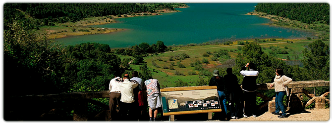
Throughout the journey a number of different viewing points will help you find out more about the landscape and delight you with the views to be found in these mountains. The most outstanding points along this route include the Cerrada de Utrero y Linarejos, where the River Guadalquivir has carved out a deep gorge; Poyos de la Mesa, a remarkable geological formation that is notable for its dramatic rocky outcrops; Nava de San Pedro, a karstic plateau ringed by mountains; the Guadalentín valley, which conducts the waters of its namesake river into La Bolera reservoir; and Estrecho de los Perales, a pronounced gorge where rocks dominate the landscape.
You will also pass close to the colossal stone ledges of Carilarga, which was home to the last native bearded vulture in Andalusia. This bird of prey has now returned to the skies above the natural park thanks to the efforts of a reintroduction programme.
The route begins at the LINAREJOS VIEWING POINT, where you will be treated to a superb panoramic view over a large part of the mountains that make up the natural park, such as the Cazorla mountain range. The great naturalist, who loved these landscapes, filmed countless scenes very near to this spot.
During the winter months you can hear the sound of water rushing over the nearby waterfall at Linarejos stream. In addition to the Félix Rodríguez de la Fuente Viewing Points route, close at hand there are a number of other, equally interesting routes that will give you a more intimate knowledge of this magnificent natural park, such as the Cerrada de Utrero and the Linarejos Viewing Point route.
The second VIEWING POINT on this route is at POYOS DE LA MESA, which offers one of the most spectacular panoramas in the park: the meseta, or tableland, of Poyos de la Mesa, which soars to an altitude of 1,635 metres. If you decide to visit the top of the meseta you will be rewarded with impressive views of the Guadalquivir valley, Vadillo-Castril and the parador (a historic, state-owned hotel) known as El Adelantado. Poyos de la Mesa is a high plateau with slopes that fall abruptly away, a magnificent example of a singular geological formation that is very common in these mountains. Amongst the pine trees you will see here is the Pino Abuelo or Grandfather Pine, one of the oldest specimens of its type to be found in the area.
Coordinates: 37.906835,-2.913155
The third VIEWING POINT on this route is at NAVA DE SAN PEDRO, where the meadows were turned into orchards and cultivated fields. This was done at a time when wood was one of the main resources of the mountains, and where in the few open spaces that existed the inhabitants of the area raised livestock and grew crops. On many occasions it was the rangers themselves who built the forest houses in suitable areas such as this, where the orchard and a few animals served to supplement their diet (and income). At this viewing point you will be able to take in the impressive views and also find out about the return of the bearded vulture to Andalusia: the landscape you are holidaying in was once the last refuge in this region for a bird that is as spectacular as it is enigmatic: the bearded vulture. This Iberian vulture vanished from these mountains in the late 1980s, which marked its total extinction in Andalusia.
DIFFICULTY. ASSESSMENT ACCORDING TO METHOD MEASURE
0
MEDIO.
Severity of the natural environment
0
Itinerary
Orientation in the itinerary
0
Displacement
Difficulty moving
0
EFFORT.
Amount of effort required
MUNICIPAL TERMS BY WHICH IT RUNS
Cazorla Sierra de CazorlaFollow us #JaénParaísoInterior


