


Ruta de los Miradores
Difficulty
Low
TOTAL DISTANCE (IN KILOMETERS)
15
SLOPE
350 m
350 m
DIFFICULTY. ASSESSMENT ACCORDING TO METHOD MEASURE
0
MEDIO.
Severity of the natural environment
0
Itinerary
Orientation in the itinerary
0
Displacement
Difficulty moving
0
EFFORT.
Amount of effort required
TIME OF THE YEAR
All year
SIGNALING
Sí
MUNICIPAL TERMS BY WHICH IT RUNS
Alcaudete Sierra SurRECOMMENDATIONS
The tour is easy, short and uncomplicated. It has a long asphalt climb that hardens on the forest road and ends with a gentle descent with short slopes. Any time of year is good, but the clear winter skies are more than advisable to enjoy the beautiful views. Don't forget to stock up on water at the Amuña fountain.
DESCRIPTION
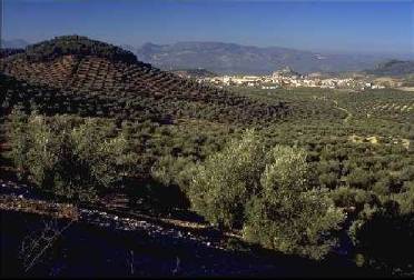
The excursion starts at the intersection of the road to Las Casillas and Villar Bajo with the road to Fuente Amuña. Located one kilometer from the town center. On the asphalt of the county, which usually supports little traffic, begins the ascent of the Sierra Ahillos. As you gain height, the panoramas unfold. At the back is Alcaudete with its imposing fortress and in front you can see the monotonous olive grove countryside. Before crowning the hill and at the end of a metal fence, leave the road to turn right (km. 6.7) along a forest path parallel to the fence. At this point there is a source of drinking water located in a ravine. You ascend through a pine forest to a high point and crossroads (km 7.7). The bicycles continue in a slight descent in order to surround the Ahillos mountain range. The magnificent views that will accompany this section begin to unfold: you can see the Sierra de La Pandera and the Sierra Alta Coloma, to the south La Parapanda does not go unnoticed and, as a backdrop to these mountainous horizons, the white peaks of Sierra Nevada . Further down, the pine forest gives way to the olive grove that will be constant until the end. Two lanes are left on the right, although the last one can be used as a shortcut. The route continues straight ahead and shortly after it reaches a crossroads (km. 11.8). On the right hand side, it crosses a ravine and immediately afterwards it begins to climb and then reaches the Vizcalmón pass. In this place the definitive descent to Alcaudete begins, which can already be seen among the fronds of the olive trees. A district with hardly any traffic, a forest track between pine groves and a rural path allow you to gently explore the contours of this sharp mountain range and enjoy its best perspectives. From the beginning, the first views are revealed: to the west the countryside stretches to the hurtful profile of the subbetic Cordoba. On the opposite slope, the landscape sneaks between the tops of the pines and it is possible to recognize each of the peaks of the Sierra Sur: from the bare rocky rocks of Alto de la Pandera to the docile top of La Martina, passing through the distant and resplendent Sierra Nevada. On the way down, a hill gives the keys to the last panoramic view of Alcaudete.
Follow us #JaénParaísoInterior


