


Ruta de las Alturas
Difficulty
high
TOTAL DISTANCE (IN KILOMETERS)
30 km
ESTIMATED RUN TIME
4 hours
SLOPE
835 m
835 m
DIFFICULTY. ASSESSMENT ACCORDING TO METHOD MEASURE
0
MEDIO.
Severity of the natural environment
0
Itinerary
Orientation in the itinerary
0
Displacement
Difficulty moving
0
EFFORT.
Amount of effort required
SIGNALING
Sí
MUNICIPAL TERMS BY WHICH IT RUNS
Valdepeñas de JaénREGION / S TO WHICH IT BELONGS
Valdepeñas de Jaén Sierra SurRECOMMENDATIONS
Although the route runs mainly on roads in good condition, a good physical condition is required to allow facing the four hills. Those less prepared should take it very easy and take advantage of the breaks to enjoy the scenery. The possibility of going down to the Barranco de los Tejos adds difficulty and unevenness to the route, each one will decide according to their strength. It is important to close the gates once they are open to go through them; your mission is to control the passage of cattle.
DESCRIPTION
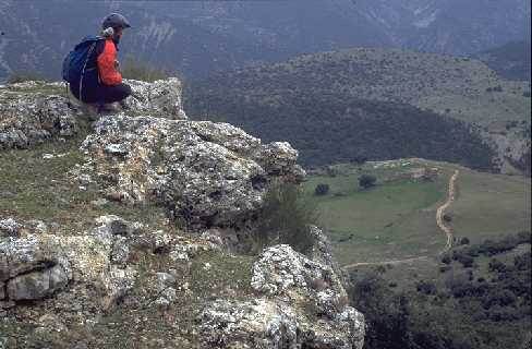
Leaving Valdepeñas in the direction of Jaén, a paved lane begins (km. 2), shortly after the gas station, which rises with steep slopes in its final section, to the port of Las Coberteras (km. 7.5). The esplanade separates the challenging rocky outcrops of the Sierra de La Pandera from the peaks of El Ventisquero. The asphalt ends at this point. The route now continues along a gravel path that gently loses height through the shady glade covered with dense tree vegetation. At Puerto Pitillos (km. 3.6) and just after crossing a barrier that prevents motor vehicles from entering, a long climb begins on the right through lush pine forests. As you gain altitude, the views unfold, first over the still waters of the Quiebrajano reservoir, and then when changing slopes over the ravine of the river that feeds it and the deep cliffs of the Sierra de los Alcabuces. After crossing a wire gate, the lane that descends to the Navalayegua ravine is left on the left, where there is an unusual grove of yew trees. The most difficult sections of the route that will almost certainly force you to set foot on the ground both on the slope and on the rocks, end when you reach another hill. Nearby, there is a semi-abandoned farmhouse surrounded by beautiful and old specimens of holm oaks. It only remains to overcome the last climb that will culminate in the Navalayegua pass (km. 21.9). In the hill the descent begins through the ravine of the Vadillo stream, which dies in the same town. The Sierra del Ventisquero is a forceful calcareous massif, on its arrogant slopes an almost wild vegetation survives in an extraordinary pure way. Holm oaks and gall oaks dominate the tree stratum and the scrub that accompanies them is sometimes very dense. On its southern slope, half hidden in the narrowness of a ravine, a community of old yew trees resists, a true relic of the past. The clearly mountainous route extracts the essence of these harsh landscapes.
Follow us #JaénParaísoInterior


