


Etapa 2: Río Madera - Segura de la Sierra

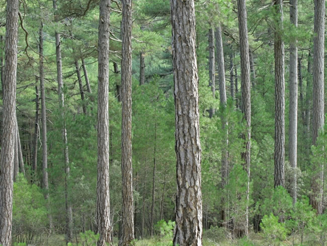
This Stage has all the ingredients to be one of the most varied and enjoyable on the Bosques del Sur Trail. It runs through forests that have been classified as the best black pine forests in Spain; travel through a stretch of the relaxing Valley of the Madera River; it passes through tiny white villages surrounded by orchards and fruit trees, such as Arroyo Canales and Moralejos; In some of its sections it runs along narrow traditional paths that have been recovered for hiking; it allows to see wide panoramic in some of its points; It facilitates knowing the place of Segura La Vieja, of archaeological interest; and ends in the Historic-Artistic Cunjunto of Segura de la Sierra.
Can you ask for more? Yes, the possibility that it offers the walker to combine various routes through the different signposted paths in the area to their liking, creating circular routes to suit them.
The Stage is a continuous up and down forest covered mountains. It begins by making a loop that begins and ends in the Valley of Río Madera, which then travels for 1.7 kilometers to leave it, climbing again a ...
This Stage has all the ingredients to be one of the most varied and enjoyable on the Bosques del Sur Trail. It runs through forests that have been classified as the best black pine forests in Spain; travel through a stretch of the relaxing Valley of the Madera River; it passes through tiny white villages surrounded by orchards and fruit trees, such as Arroyo Canales and Moralejos; In some of its sections it runs along narrow traditional paths that have been recovered for hiking; it allows to see wide panoramic in some of its points; It facilitates knowing the place of Segura La Vieja, of archaeological interest; and ends in the Historic-Artistic Cunjunto of Segura de la Sierra.
Can you ask for more? Yes, the possibility that it offers the walker to combine various routes through the different signposted paths in the area to their liking, creating circular routes to suit them.
The Stage is a continuous up and down forest covered mountains. It begins by making a loop that begins and ends in the Valley of Río Madera, which then travels for 1.7 kilometers to leave it, climbing again a hillside with dense pine forests and holm oaks. After Collado Verjaga, the route heads towards the village of Moralejos, going down the well-preserved slopes of the Dehesa Carnicera, full of trees.
The two neighborhoods of Moralejos, that of Arriba and that of Abajo, will captivate the walker because they are the purest expression of the rural environment of the mountain villages of Segura. Later, if desired, a detour allows you to go up to Segura la Vieja, where there are remains of an old settlement and from where unforgettable views can be seen. Segura de la Sierra is the finishing touch for a route like this, with its castle, its Arab Bath and its white alleys from which time and time again the contrast between the intimate and familiar corners and the wide views that are contemplated surprises us. .
Technical information
Route Name Rutas Bosques GR247
Rutas Bosques GR247 1: Etapa 2: Río Madera - Segura de la SierraHUSO 30S
Río Madera: x533157 y4233191
Segura de la Sierra: x530621 y423941
Río Madera: x533045 y4232984
Segura de la Sierra: x530509 y4239208
TOTAL DISTANCE (IN KILOMETERS)17600
Asphalt or cement section 18,29 %
Section of track or forest road or promenade 40,74 %
Senda section 40,97 %
tramos-de-Vía-pecuaria 0 %
ESTIMATED RUN TIMEO
5 h 57 minMAXIMUM SLOPE338 m
DIFFICULTY. ASSESSMENT ACCORDING TO METHOD MEASURE
2
MEDIO.
Severity of the natural environment
2
Itinerary
Orientation in the itinerary
2
Displacement
Difficulty moving
3
EFFORT.
Amount of effort required
TOTAL DISTANCE (IN KILOMETERS) 19540 M
Start
The Aldea de Río Madera is accessed from Segura de la Sierra by the JF-7038, and from Hornos by the JF-7039, which starts from the A-317a road that goes up the Garganta de Hornos.
Final
Access to Segura de Segura de la Sierra is via the JA-9118 road.
INTERMEDIATE POINTS
PLACE
POSITION
TYPE OF ROAD
Km 4,3
Carretera
Km 6
Carretera
Km 7,6
Carretera
Km 8,4
Pista forestal
Km 10,2
Carretera
Km 13,2
Carretera
CYCLABILITY
Much of this Stage runs along paths. Between points 1 and 3, as well as between points 4 and 5, there are sections with steep slopes and very uneven terrain. At kilometer 12.1 there are stairs.
WATER POINTS
Arroyo Canales, Cortijo de los Espinos, Valle de Río Madera, Moralejos de Abajo, Moralejos de Arriba, La Tejadilla, Segura de la Sierra.
PREFRESHING POINTS
On the trail: Segura de la Sierra
Near the trail: Orcera
LINKS WITH OTHER TRAILS
GR-147, PR-A 198
Rutómetro
Arroyo Canales (River Madera)
This Stage begins in the small village of Arroyo Canales, which is just five minutes from Río Madera. Very few inhabitants live there throughout the year, but the place could not be more seductive, with the small white houses surrounded by large pine forests at the bottom of a cool and narrow valley.
We find the starting panel on the road that goes up to El Campillo, on the right. Our route, which coincides for 2.5 kilometers with the GR 147, enters the forest of large black pines along a poorly defined path in its first meters, so you have to be attentive to the beacons. At 300 m the path appears perfectly defined and we immediately gain altitude, revealing great views.
At 500 meters we reach a small hill where we have views in all directions, highlighting, in front, the mount of El Yelmo. Soon the climb is smoother, and under the pines grows a closed understory of holm oaks. From time to time we enjoy wonderful views towards the elevations that flank the Valley of Río Madera on the opposite slope, highlighting the Cerro del Toril and the Calares de Peña Rubia and Los Caracoles.
At kilometer 1.6 we come to another hill, in the middle of an increasingly mature forest, with beautiful black pine trees with a parasol crown. We cross a stream, normally dry, and we go parallel to it, always among pines, holm oaks and hawthorn trees, along a poorly defined but perfectly marked path.
Collado
The route reaches a third hill, well signposted because it is very important, since two Stages of the Bosques del Sur Trail cross there. One is Stage 2, which would take us on the left to the Casa Forestal de El Campillo Refuge for 2.5 km, and in front of Segura de la Sierra through Trujala for 7.5 kilometers, coinciding with the GR 147.
Ours heads back to the Río Madera Valley, from which we have started, leaving the junction with the GR 147 and turning sharply to the right, almost in the opposite direction, to go to Segura de la Sierra via Moralejos in 15.1 kilometers. Combining these two paths, plus the one from Río Madera to El Campillo via La Huelga de Las Vigas, signposted by the Segura Hydrographic Confederation, and the small road from Río Madera, the hiker can design several circular routes, each more attractive.
We flatten a stretch under the holm oaks, paying attention to the beacons, and 200 meters later we reach a pleasant flat, where we turn right to take a clear traditional path along which we descend towards the Río Madera Valley. This section is very attractive because to the front and to the right great panoramic views are opening towards the other side of the valley. At kilometer 3.6 we arrive at the Cortijo de Los Espinos, where there is a fountain-washhouse at the foot of beautiful walnut trees. The route continues along a forest track next to a charming Christmas tree with fruit trees.
Wood River Valley
The route reaches the JF-7038 road, returning to the bottom of the Río Madera valley, since what we have done is a kind of clockwise semicircle. If we wanted to complete a loop back to the village, we would only have to travel 1.6 kilometers on the road to the right. Our Stage, however, turns left and runs along the road for 1.7 kilometers.
This section, despite going on asphalt, is one of the most attractive of the Stage, since the valley, flanked by slopes covered with one of the best black pine forests in Spain, is also dotted with poplar groves, orchards, fruit groves and small farmhouses, in a pleasant landscape where the trace of traditional human activity is harmoniously integrated into its mountainous environment, transmitting a particularly bucolic feeling in spring and autumn.
We will find on the right a crossroads through which it is advisable to deviate a few meters to discover the tiny and charming village of Prados de la Mesta. Back on our route along the road, at kilometer 5 we will pass a fountain on our left, and 500 meters further on we will arrive at the Río Madera Youth Camp. Advancing another 400 meters we leave the Cortijo de Cerrico Montero on the left, and immediately we leave the road.
Path to Collado Verjaga
At this point we take a path that ascends to the left, heading north. We change the environment, going back into the forest to leave the valley. We climb through an impressive pine forest, which higher up is transformed into a holm oak whose shady atmosphere creates a magical halo like an ancient forest.
At kilometer 7.2 we flatten through Collado Verjaga, to go down towards the JF-7016 road, changing the environment again because we have definitively left the surroundings of the Madera River Valley, appearing in some moments before our eyes the unmistakable picture of Segura de la Sierra with its castle on top.
Dehesa Butcher
We cross the road and continue along the forest track that appears just ahead. We enter the Dehesa Carnicera, which is a mountain belonging to the Segura de la Sierra municipality, very well preserved. Our track, narrow and delicious, descends through a forest more open than that of the previous section, with large specimens of black pine and holm oaks, and dotted with hawthorns and some pespejones or mountain pear trees (Sorbus torminalis) that add a touch of color autumn. The presence of junqueras indicates a significant degree of humidity in the soil during some sections.
After traveling 1.2 kilometers along this track we find another, wider, which is important, because to the right it leads to the nearby area of ??Navalcaballo, where the Forest Defense Center is located, and to the left it heads towards the village of El Robledo, next to Cortijos Nuevos. We cross it and continue ahead along a wide path that descends with a notable slope in some sections. The forest becomes more shady and closed, and in some stretches there are magnificent views towards the reddish cliffs of Los Poyos de Segura la Vieja.
Moralejos de Abajo
Our route reaches the bottom of the valley of the newly born Trujala River, which is still just a stream, and after crossing it, we enter the small village of Moralejos de Abajo, with its simple white houses, its fountain-laundry and its farmlands. From here, the signposting for our Stage has yellow, red and white stripes because it coincides with the PR-A 198 path. It is advisable to deviate along it for at least a stretch and enjoy its good views and then return to our Stage. We continue along a wide track that leaves the village to the right, facing Mount Navalperal.
Moralejos de Arriba
The route reaches the Moralejos road. The village of Moralejos de Arriba is on the right, and it is essential to deviate a few meters to visit it. It is somewhat larger than Moralejos de Abajo and has all the elements that make the villages of the Sierra de Segura so attractive: small and simple white houses, Arabic tile roofs, community oven, laundry room, narrow streets and even a small square. where the festival continues to be held during the festivities in summer.
And all this surrounded by a dreamlike landscape, with the era, the orchards -that are still being cultivated- and the poplars, the great vertical poyos of Segura la Vieja just above the village, and in the distance the mountains covered with trees, like Navalperal and Navalcaballo.
After wandering through the village we return to our route, that is to say, to the road, where we will find a fountain on the right. After traveling 400 meters we turn off onto a traditional path that goes right and goes into the forest. We walk again wrapped i ...
Moralejos de Arriba
The route reaches the Moralejos road. The village of Moralejos de Arriba is on the right, and it is essential to deviate a few meters to visit it. It is somewhat larger than Moralejos de Abajo and has all the elements that make the villages of the Sierra de Segura so attractive: small and simple white houses, Arabic tile roofs, community oven, laundry room, narrow streets and even a small square. where the festival continues to be held during the festivities in summer.
And all this surrounded by a dreamlike landscape, with the era, the orchards -that are still being cultivated- and the poplars, the great vertical poyos of Segura la Vieja just above the village, and in the distance the mountains covered with trees, like Navalperal and Navalcaballo.
After wandering through the village we return to our route, that is to say, to the road, where we will find a fountain on the right. After traveling 400 meters we turn off onto a traditional path that goes right and goes into the forest. We walk again wrapped in the trees, seeing the El Yelmo mountain in the background, and, for the third time in this Stage, with the pleasure of traveling an old path that was practically lost and that has been recovered so that it remains alive thanks to the hiking.
Approximately 800 meters after starting this path, there is an unmarked and poorly defined path that goes up to the Segura la Vieja area, whose visit is recommended. To identify its start, we must be careful when passing by some large vertical walls to the right. About 200 meters later we find two beacons for the continuity of the path, and in the middle of both, a path to the right, where there is another beacon in the wrong direction, since the Stage does not go up it. We can also look at a few piles of stones that are usually in the same boot.
Once located, we go up it and it is easy to follow it, since it is more defined than it seems at first, and there are also milestones with stones that mark the path. As we climb we have to the right the great cliffs of the Poyos de Segura la Vieja, and finally we reach a clear platform from which wonderful panoramic views are contemplated in all directions.
We are in Segura la Vieja, and if we look at the ground we will see stones already almost buried that mark the contour of ancient buildings, since there was a human settlement there. It was considered for a long time that its origin was Iberian, but more recent research is inclined to speak of a late ancient or high medieval town.
According to the most recent studies, the Hispanic Muslim population that inhabited this town would have abandoned it at the end of the 9th century or the beginning of the 10th, in the time of Abd-al Rahman III, to move to Segura de la Sierra –then called Saqura- and enjoy of better living conditions.
Returning to our route, the Stage continues along the old path with great views in its last section towards the Navalcaballo and El Yelmo mountains. From kilometer 11.7, after a sharp curve to the right, we begin to descend and another world opens up before our eyes, making out in the distance, to the west, the Sierra de Las Villas, the outer alignments of the Sierra de Segura and the town of Segura de la Sierra, while to the north we see Mount Peñalta and to the northeast the mountains around Siles.
Finally we go down some stairs to the Moralejos road (kilometer 12.1), which we take to the right. About 300 meters later we reach the JV-7032 road, which we take to the left in the direction of Segura de la Sierra. We walked along it for 800 meters enjoying excellent views to the north, seeing below the village of Linarejos, beyond the Peñalta, in the background the mountains of El Cambrón and the Puntal de Rayuela (also called La Ajedrea and Siles), and at the end the mountains of the neighboring Calares del Mundo and La Sima Natural Park, in the province of Albacete.
Track of La Tejadilla
At this point we leave the road and take a narrow forest track that we find on the right, along which we walk between black pines, holm oaks and junipers. At kilometer 14.3 we find the La Tejadilla fountain on the left, and a few meters further on, going down to the right, a small trough, which is a good place to rest. Further on, as our track turns to the west and south, views of Orcera and Mount Peñalta open up.
Shortly before the end of the track, the castle of Segura de la Sierra suddenly appears before our eyes, already very close and from a perspective that is not the one that is usually had from the asphalt roads.
Segura de la Sierra
The La Tejadilla track ends at the Segura de la Sierra road. In front we have the climb to the castle, which houses the Thematic Space of the Border Territory, and to the right the municipal swimming pool, small but with impressive views, and which in summer is the perfect place to end the Stage with a good dip. About 500 meters further on we arrive at the town of Segura de la Sierra, declared a Historic-Artistic Site and one of the most beautiful and interesting towns in the Natural Park due to its architectural heritage and its spectacular location.
Additional information
Mountains ruled by admirals
Thematic Space of the Maritime Province in Orcera The black pines that can be seen along this route, with their straight and tall trunks, have been one of the keys to the historical evolution of the Sierra de Segura, since the excellent aptitude of their wood for civil and naval construction it made them a highly coveted resource. To the point that, strangely enough today, there were times when all these mountains belonged to the so-called Maritime Province of Segura de la Sierra, whose declaration in 1748 had a strategic importance of the first order for the State, which was It thus ensured the supply of wood for the construction of warships.
On that date, some Marine Ordinances came into force that turned the old Ordinances of the Common of Segura and its Land (which are discussed in Stage 1) into a dead letter. There was an undeclared -but drastic- expropriation of the communal forests from which the majority of the mountaineers lived and a strong social trauma that caused many conflicts.
The re ...
Mountains ruled by admirals
Thematic Space of the Maritime Province in Orcera The black pines that can be seen along this route, with their straight and tall trunks, have been one of the keys to the historical evolution of the Sierra de Segura, since the excellent aptitude of their wood for civil and naval construction it made them a highly coveted resource. To the point that, strangely enough today, there were times when all these mountains belonged to the so-called Maritime Province of Segura de la Sierra, whose declaration in 1748 had a strategic importance of the first order for the State, which was It thus ensured the supply of wood for the construction of warships.
On that date, some Marine Ordinances came into force that turned the old Ordinances of the Common of Segura and its Land (which are discussed in Stage 1) into a dead letter. There was an undeclared -but drastic- expropriation of the communal forests from which the majority of the mountaineers lived and a strong social trauma that caused many conflicts.
The residents did not benefit from the enormous value of the wood, suffering rigid and repressive management by the Navy authorities, who established a special court in Orcera. The councils, whose coffers were fed until then from the sale of wood, were left in ruins, and livestock was also greatly affected by the restrictions that were imposed.
The Ministry of the Navy decided to conserve the forest wealth, but it failed due to bureaucracy, corruption and conflicts with the Ministry of Finance, with whom it took turns in logging, causing heavy deforestation.At this time it is known that it changed greatly the composition of the forests, passing to pine forests a good part of the old holm oaks, gall oaks and melojares of very high ecological value.
This surreal maritime province lasted until 1836, although the Segura pine, as the black pine was then called, continued to provide a large percentage of the wood with which some of the higher tonnage ships that were manufactured in the second half of the century were built. XIX century.

Follow us #JaénParaísoInterior


