


Calar del Espino
This Bypass places its beginning halfway through Stage 20 of the Bosques del Sur Trail, specifically 8.1 kilometers from Prado Maguillo. It is a route with two well differentiated parts, the first linear, which will have to be done back and forth with a length of 1.8 kilometers and the second a circular route of 4.1 kilometers.
Therefore, if we choose to complete Stage 20 and the Derivation to Calar del Espino in one day, it will mean traveling approximately 24.9 kilometers.
This is one of the most attractive routes in the Sierra de Segura, due to the ecological relevance of the area and the landscapes that can be seen. The path is a real balcony from which practically all the wild areas and peaks of the Park can be seen.
Towards the north we will see the Sierra del Agua, whose name is due to the existence in distant times of ingenious hydraulic mechanisms for sawing wood, powered by the water of the Tus River, which rises nearby.
The route runs entirely through the Las Acebeas-Nava del Espino Reserve Area, which as such enjoys the highest level of protection withi ...
This Bypass places its beginning halfway through Stage 20 of the Bosques del Sur Trail, specifically 8.1 kilometers from Prado Maguillo. It is a route with two well differentiated parts, the first linear, which will have to be done back and forth with a length of 1.8 kilometers and the second a circular route of 4.1 kilometers.
Therefore, if we choose to complete Stage 20 and the Derivation to Calar del Espino in one day, it will mean traveling approximately 24.9 kilometers.
This is one of the most attractive routes in the Sierra de Segura, due to the ecological relevance of the area and the landscapes that can be seen. The path is a real balcony from which practically all the wild areas and peaks of the Park can be seen.
Towards the north we will see the Sierra del Agua, whose name is due to the existence in distant times of ingenious hydraulic mechanisms for sawing wood, powered by the water of the Tus River, which rises nearby.
The route runs entirely through the Las Acebeas-Nava del Espino Reserve Area, which as such enjoys the highest level of protection within the Natural Park due to the presence of numerous endemic and endangered plant species. We will pass through impressive black pine forests, dotted with holly, maples, gall oaks and hawthorn trees, as well as a well-preserved holm oak grove on the middle slope.
At the top of the calar, at the northern end of which there are remains of the old fire guardhouse of Fuente del Tejo, we will contemplate the typical karst modeling, as well as rich grasslands, broom and sand pits. The views that two magnificent panoramic viewpoints strategically located to the north and east give us are deep and grand.
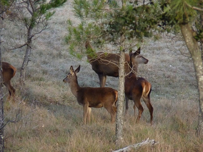
A large part of the great fauna of the Park frequents these places, such as the mountain goat, the deer, the golden eagle and the griffon vulture.
Technical information
Route Name Rutas Bosques GR247
Rutas Bosques GR247 9: Calar del EspinoHUSO 30S
Pista a Calar del Espino: x540018 y4236801
Pista a Calar del Espino: x539906 y4236594
TOTAL DISTANCE (IN KILOMETERS)7700
Asphalt or cement section 0 %
Section of track or forest road or promenade 51,94 %
Senda section 48,06 %
tramos-de-Vía-pecuaria 0 %
ESTIMATED RUN TIMEO
2 h 41 minMAXIMUM SLOPE285 m
DIFFICULTY. ASSESSMENT ACCORDING TO METHOD MEASURE
2
MEDIO.
Severity of the natural environment
2
Itinerary
Orientation in the itinerary
2
Displacement
Difficulty moving
2
EFFORT.
Amount of effort required
Rutómetro
Track to Calar del Espino
Between the Cortijos de La Viuda and the Collado de Góntar starts the narrow track that we will cross in the initial part of the route. It is very easy to identify the exact place by the existence of wooden railings that delimit a parking area, in addition to finding the starting panel of this route.
In addition to the signaling of the derivation in white and red, we will find white, red and yellow beacons and markings, as part of the route coincides with the old PR-A 178 and we can also find beacons with white arrows also to indicate the correct direction. Shortly after starting the path through a thick and humid black pine forest, we will contemplate some specimens of holly, a northern species, which finds in these places the right microclimate to have one of its last southern paradises.
1.3 kilometers from the start, we leave a track on the left that leads to the aforementioned PR-A 178, which from now on will accompany us on our route. 300 meters further on we pass several fenced areas, one of them with an antenna, and another is a mountain goat trap that has been used mainly for health purposes, passing the track next to a small shed that is part of it.
Circular route
At this point the circular section begins. It is advisable to travel it in an anti-clockwise direction, to smooth the ascent. Towards the left we see the wide and little traveled road through which we will then return to this point.
We are in one of the most ecologically relevant enclaves of the Park, so it is important that we go as unnoticed as possible so that our passage does not cause alterations.
It is relatively easy to surprise the elusive goats and ibex and the graceful deer, as well as to see vultures and various birds of prey fly overhead.
Hoya del Trigo Fountain
The narrow track that we have traveled from the beginning seems to get lost and we find a tornajo (fountain-trough) on the right. Right at this point we leave the track to continue the ascent along a restored path to the left between holm oaks in the middle of the slope. In tornajos it is common to find tadpoles of various species of amphibians, some of them with a very limited distribution.
As we ascend, the arboreal vegetation becomes more limited, and the broom and sandy areas begin to have a certain role, between rocky and rocky areas. When we finish the ascent, we will be surprised by a wide cove of almost two kilometers in length.
Bifurcation of paths
The path in the Calar is very easy to follow and it is delimited laterally for the most part by rows of stones. Against the left, we see another path with the same characteristics that we will travel later, but first we must continue towards the north end of Calar, continuing the path marked north.
Cerro del Espino viewpoint
We reached the geodesic point of Espino and the North Calar viewpoint, with deep views over the Sierra del Agua, the Tus Valley, the Calar del Mundo and the Cerrico de las Mentiras, among others.
The diversion as such and the PR-A 178 only have signs up to this point, but the path that we have previously left to the left is worth it, as it is part of a path recently restored by the Ministry of the Environment. It is conditioned in the same way as the one that brought us to this point and can be followed without any possible misunderstandings. Thus we will enter the heart of the calar, allowing us 360º panoramic views.
Calar Nava del Espino viewpoint
It offers us the best possible panoramic view of the calar itself and places such as the Collado de Góntar, the castle of Segura de la Sierra, the Banderillas, the Sagra de (Granada), the Calar del Mundo (Albacete) and the La Mancha plain (Ciudad Real ), among many other places.
From this viewpoint the path runs towards the southern end of the calar, where we can see no less than several specimens of yew encased on the rocks. Afterwards, the path turns to the northeast, to descend vertiginously between the rocks towards the place where we had started the circular route, finding a sign that indicates the end of the path and taking 5.9 kilometers from the beginning.
From there we turn right along the track we traveled at the beginning to return to the starting point of the Derivation.
NOTE: Points 7 and 8 of the Profile coincide with points 2 and 1 respectively, as it is a route with a circular section.

Follow us #JaénParaísoInterior


