


Castillo de Giribaile
Yacimientos Arqueológicos
Monumentos
Carretera comarcal A-312. 23220, Vilches Cómo llegar
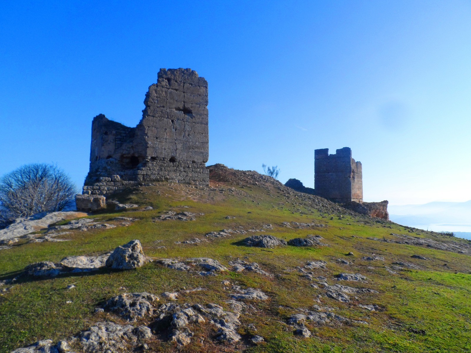
Giribaile constituye un conjunto arqueológico cuya evolución histórico-arquitectónica puede leerse hoy en día en la superposición de estructuras de fortificación. La meseta del cerro está acotada mediante una línea de murallas que defendieron un oppidum ibérico. Al pie del escarpe del cerro encontramos un interesante hábitat rupestre con aposentos tallados en la roca viva entre la Tardoantigüedad y la Alta Edad Media. Finalmente, en el extremo noreste de la meseta, se conservan los restos de una fortaleza medieval, conformada por dos torres cuadradas de tapial, un pequeño aljibe y algunos lienzos de muralla de mampostería, un baluarte que jugó un importante papel en los conflictos políticos y militares que se desarrollaron en varios periodos de al-Ándalus.
El castillo de Giribaile posee una estratégica posición sobre un cerro amesetado, entre los ríos Guadalimar y Guadalén, rodeado de acuíferos y manantiales. Es una fortificación que evolucionó desde un simple refugio para comunidades rurales, que aprovecha los elementos de la antigua fortaleza ibérica y la escarpada orografía del terreno, hasta convertirse en una sólida fortaleza de mampostería irregular dotada de torres y lienzos de muralla, que defendería a un grupo de rebeldes muladíes, para posteriormente convertirse en primera línea fronteriza frente a los ejércitos cristianos. Se trata de una de las fortalezas giennenses que mantienen, sin apenas modificación, su antigua estructura islámica.
Información

La fortaleza medieval de Giribaile se sitúa en el extremo noreste de un alargado cerro amesetado, ocupando un amplio saliente rocoso protegido por acantilados de roca que le sirven de defensas naturales, y por una vaguada en el sur que le separa del resto de la meseta.
Actualmente se extienden por la mayor parte de la planicie los restos de un oppidum ibérico, cuyas estructuras pudieron ser reutilizadas por los habitantes de este asentamiento a lo largo de la Edad Media.
La fortificación emiral-califal fue construida en mampostería irregular trabada con mortero de cal y arena. Su planta irregular tiene tendencia triangular, adaptándose a la orografía del terreno y aprovechando algunos restos de la antigua fortificación ibérica. Torres y lienzos de muralla se levantan sobre la base rocosa, a modo de muros en cremallera que reproducen los sucesivos entrantes y salientes del espolón.
La puerta principal de acceso al interior de la fortaleza, se emplazó en el lienzo suroeste, estaba protegida por dos torres, mientras que en el lienzo noroeste se abría otra puerta o poterna, a la que se accedía tras ascender por una suave senda que discurría por la ladera del cerro. Se trataba de un complejo acceso en codo formado por tres torres, la primera edificada sobre un pequeño espolón rocoso de la ladera, desde la que partía un lienzo que enlazaba con la más oriental de las otras dos torres, que flanqueaban la puerta.
Entre los siglos XII y XIII, los almohades llevaron a cabo una reestructuración de la fortificación, que afectó principalmente al sector sur, donde se va a levantar una nueva torre de tapial de argamasa, sobre un sólido basamento de grandes sillares de piedra caliza, dividida interiormente en tres estancias.
Estaba rodeada, en tres de sus frentes, por un antemuro, a modo de barrera de corta altura y edificado con la misma técnica constructiva, que dejaba un espacio o liza de 2 m de anchura entre ambos. Este antemuro se extendería de forma paralela a la muralla meridional, reforzando el flanco sur de la fortaleza. En el lienzo suroeste, una de las torres que protegían la puerta principal del castillo fue forrada por tres de sus frentes con un grueso revestimiento de tapial de argamasa levantado sobre un basamento de mampostería regular, a la vez que se rellenó, convirtiéndola en un cubo macizo.
En la actualidad, aunque se puede distinguir el trazado de la fortificación, solo se conserva el alzado de dos torres cuadradas de tapial y de algunos lienzos de muralla. En el interior del castillo permanecen los restos de un pequeño aljibe rectangular cubierto con bóveda de cañón y de dos dependencias anexas, posiblemente utilizadas como almacenes.
El asentamiento de Giribaile ha sido ocupado a lo largo de la historia, en diferentes periodos de tiempo más o menos duraderos, correspondiendo la ocupación más temprana a un poblado de la Edad del Bronce.
En época ibérica el cerro estuvo ocupado por un oppidum fortificado de 14,56 hectáreas, que formó parte del pago de Cástulo, territorio político que en el siglo IV a.C. alcanzaba las fronteras naturales de las cabeceras de los ríos Guarrizas y Montizón, donde se localizan los santuarios de Collado de los Jardines y Castellar de Santisteban. La desaparición de este asentamiento está vinculada a un episodio de destrucción violenta, con el incendio de la ciudad, que pudo tener lugar en el marco de una acción de castigo desarrollada durante la Segunda Guerra Púnica.
La posición estratégica de la meseta de Giribaile, junto a la existencia de abundantes manantiales naturales, fueron determinantes para la ocupación prácticamente ininterrumpida desde la Tardoantigüedad hasta la Baja Edad Media.
Los primeros momentos de esa ocupación podrían remontarse a los siglos VI y VII d.C., momento en que los habitantes del valle lo abandonan, trasladándose al cerro. En la pared rocosa del lado este habilitan una serie de cuevas naturales, que amplían y transforman para constituir un complejo hábitat troglodítico de altura, mientras que por la meseta se expandiría un poblamiento más o menos disperso, protegido aún por los elementos de fortificación edificados en época ibérica.
Este hábitat se mantuvo tras la invasión islámica hasta que, a lo largo de los siglos IX y X, la inestabilidad creada por las sublevaciones de finales de época emiral, empuje a la población a concentrarse en la plataforma norte, convirtiéndose en un hisn (castillo-refugio) que aglutinaría a gran parte de los habitantes de la zona. Es posible que las reparaciones de las antiguas defensas ibéricas y la construcción de una nueva fortaleza en el extremo noreste del cerro, se debiese a ibn al-Sāliya, rebelde muladí que se enfrentó a los emires omeyas.
Una vez consolidada la islamización de al-Ándalus, bajo Abd al-Rahmān III, se abandonan buena parte de los asentamientos defensivos de altura, y los que permanecen se transforman en puntos estratégicos para controlar el territorio. En el entorno de Giribaile la población debió ser obligada a trasladarse a centros en desarrollo como Vilches, Baeza o Santisteban.
Finalmente, los acontecimientos políticos y militares acaecidos en al-Ándalus entre los siglos XII y XIII, que llegaron a convertir el Alto Guadalquivir en un territorio prácticamente independiente durante periodos muy concretos, así como la expansión hacia el sur de los ejércitos cristianos, promovieron un proceso de fortificación, intensificado por los almohades, para controlar la cabecera del Guadalquivir. Las últimas remodelaciones del castillo de Giribaile corresponden a este momento histórico, en el que se refuerza principalmente su flanco sur, más accesible.
Tras su conquista por los castellanos, en 1227, Giribaile se integró en el territorio de la Comunidad de Villa y Tierra (Concejo de Realengo) de Baeza, perdiendo su importancia militar.
LEYENDAS
Leyenda de la muerte de Gil Baile. Un noble de Baeza, don Gil Baile, señor de las tierras donde se asienta el castillo al que da nombre, mandó grabar en la puerta de su casa, bajo el escudo de su linaje: “Entre río y río todo lo que hay es mío. Esta es la tierra de Gil Baile que no morirá de sed ni de hambre”.
Una mañana salió de caza con otros distinguidos nobles. Descubrió un hermoso venado que el noble siguió al galope por el monte, hasta que se precipitó al abismo de una oscura sima de la que no pudo salir. Era un camino poco transitado y nadie escuchó sus gritos de auxilio, hasta que finalmente falleció, muriendo de frío, de sed y de hambre.
? ![]()
Síguenos #JaénParaísoInterior


