DETOUR 02: Forestrand House Refuge del Campillo - Summit ofl Yelmo
Hiking, GR247 Forest Routes
Segura de la Sierra



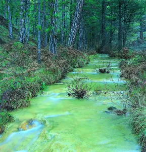


This route, which is part of the small and beautiful village of Segura de la Sierra, leads along small mountain roads to the valley of Rio Madera, ascends to the vicinity of the Yelmo and returns to the starting point.
ROUTE NAME
Segura de la Sierra - Río Madera
TRAIL TYPE
--
DIFFICULTY
--
TOTAL DISTANCE (IN KILOMETERS) --
Stretch of asphalt or concrete:
Section of track, forest road, or dry watercourse:
Trail section:
Sections of livestock trails:
HUSO 30S
ESTIMATED TRAVEL TIME
ROAD SURFACE TYPE
Forest track
--
--
DIFFICULTY. RATING ACCORDING TO THE MIDE METHOD
--
MEANS
Severity of the natural environment
--
ITINERARY
Route guidance
--
DISPLACEMENT
Difficulty moving about
--
EFFORT
Amount of effort required
ACCESSIBILITY TYPE
TIME OF YEAR
SIGNALING
Sí
MORE INFORMATION
TUNNELS
STEEL VIADUCTS
METAL WALKWAYS
WATER POINTS
PONTOONS
GUARD BOOTHS AND BARRIERS
SWITCHMAN'S CABINS
CYCLABILITY
RECREATIONAL OR SPORTS AREAS NEAR THE TRAIL
AID STATIONS
LINKS TO OTHER TRAILS
SHELTERS
RECOMMENDATIONS
OTHER INFORMATION OF INTEREST (ARCHITECTURAL OR HISTORICAL-CULTURAL, GEOLOGICAL-ECOLOGICAL)
Technical Description
Its main attractions are the large forests of pine laricio, the head of the valley of the river Madera and some small villages.
Below we tell you how to make the route and suggest some possibilities:
Km 2.8.To the right part of the road to the small and hidden village of Moralejos, which is reached in a few minutes. We advise you to visit her, because she has a very harmonious environment and is well preserved.
Km 6.The Royos. From this tiny village you can see beautiful views of the header of the Trujala valley. Km 8.3. Important cross with many indications. We turn right, towards Rio Madera, on the JF-7016 road. To the left we would go to Las Azebeas and Siles. Here is a significant change in the plant environment, as we have entered the area of the pine pine larice.
Km 8.7.On the left, a forest track opens that gives access to Navalespino, the Collado de Góntar and the abandoned village of Prado de Juan Ruiz, among other areas of high quality landscape.
Km 9.5.Fountain and forest house of Navalhora. The pinar acquires all its splendor. Three hundred meters further, take the long forest track from Navalhora to El Robledo to the right, for which we recommend walking.
Km 10.1.At this crossing, our route follows to the left, towards Rio Madera, on the JF-7038 road. From here we go down and we'll see large copies of complaints and some twins. Km 12.3. Start a forest track to the left, to the counter. It gives access, without taking any detour, to the far-off villages of La Tobilla and Prado Espinosillo.
Km 13.5.Los Negros' controlled camp area. It has a fountain and tables, and is accessible for people with reduced mobility. An excellent place to rest under large larity pines. From here, during the 4.3 km that separate us from the village of Arroyo Canales, we recommend to walk quietly next to gardens and small cortijos, always close to the river Madera and in the middle of one of the best pine lario forests in Spain.
Km 17.8.The village of Arroyo Canales, sometimes given the name of the village of Rio Madera, is a strategic point throughout the area. At this very marked crossing, we turn right on the JF-7039 road. From here on the route rises and the forest is less lush, but you gain splendid views. We will find several forest tracks signposted to El Jaral, La Huelga de la Vigas and the Collado de Los Asperones. All of them are interned in magnificent places.
Km 22.4.Very marked cross where we turn right, on the JF-7016 road. Two hundred meters later, we ignored the left crossing towards the Hornos de Segura and followed the front. From here on the plain route and the environment becomes more lush.
Km 23.7.We arrived at the location of El Campillo, where there is an old forest house. To the left, the asphalted forest track goes up to El Yelmo. Both on the road and at the summit, the views are extraordinary.
Km 32.5.We found again the crossing through which we went down to Rio Madera. From here on, we return to Segura de la Sierra on the same route we brought.
PRACTICAL PARTICULARS
The route is 42 km, and it starts and ends in Segura de la Sierra. The beginning from which we count the kilometers is at the exit of Segura de la Sierra on the road JV-7032, exactly at the point where the road to the castle comes right.