

Ravine of la Hoanda-La Pandera
Description
The beginning is at the Km 14 of Jaén to the Embalse del Quiebrajano, next to the so-called Casa del Pintor (house with green graffiti on the walls), in the vicinity of the road crossing between the Cañada de las Azadillas and the Embalse del Quiebrajano.
Datos de la ruta
ROUTE NAME
Barranco de la Hoya-La Pandera
TRAIL TYPE
--
DIFFICULTY
--
TOTAL DISTANCE (IN KILOMETERS) --
-
Stretch of asphalt or concrete: --
-
Section of track, forest road, or dry watercourse: --
-
Trail section: --
-
Sections of livestock trails: --
HUSO 30S
ESTIMATED TRAVEL TIME
ROAD SURFACE TYPE
Trail
--
--
DIFFICULTY. RATING ACCORDING TO THE MIDE METHOD
--
MEANS
Severity of the natural environment
--
ITINERARY
Route guidance
--
DISPLACEMENT
Difficulty moving about
--
EFFORT
Amount of effort required
ACCESSIBILITY TYPE
TIME OF YEAR
SIGNALING
No
MORE INFORMATION
TUNNELS
STEEL VIADUCTS
METAL WALKWAYS
WATER POINTS
PONTOONS
GUARD BOOTHS AND BARRIERS
SWITCHMAN'S CABINS
CYCLABILITY
RECREATIONAL OR SPORTS AREAS NEAR THE TRAIL
AID STATIONS
LINKS TO OTHER TRAILS
SHELTERS
RECOMMENDATIONS
OTHER INFORMATION OF INTEREST (ARCHITECTURAL OR HISTORICAL-CULTURAL, GEOLOGICAL-ECOLOGICAL)
Technical Description
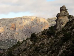
We take a track that goes up the ravine of Estoril and after leaving to our left a huge rocky coat, in which there are curious prehistoric engravings with geometric shapes, we go out to a valley dominated by the castle of Otiñar. There comes a sidewalk that, after entering a narrow throat, rises with a strong slope all over the ravine of the Hoya del Caño. We ignore all the detours to the left and right and pass by the Bishop's source. After a very hard rise in some sections the sidewalk, which passes almost all the time on the right side of the ravine in the sense of ascension, we are located in the Llanos de las Navas, beautiful enclave more than 1500 m high where the forest of lush pine trees with fresh meadows is altered. In winter it is not uncommon to find them snowy. To get here, we'll need about three hours and a lot of physical effort.
The plains are taking a slope to the side of the Pandera, which we have in front of us. In the upper area, on its eastern side, there is a cave disguised by a huge rock that is in front of its entrance. Right on the top of this cave, which serves as a shelter for pastors and mountaineers, a path begins that, through a rocky high mountain terrain will lead us in an hour and a half more to the summits of the Pandera. The sidewalk, which must be located by reference to the cave, is clearly marked at first, as it takes place by opening way between low mountain, but we will have to pay attention to not lose it as we gain height. In days of low visibility or bad weather it is risky to venture to the summit. We will unwind in a vaguada that forms between the Peña del Altar (1809 m) on our left, and the Alta de La Pandera (1870 m) on our right. In addition to this last summit, there are old military facilities. In the Peña del Altar we will see two small constructions: a fire guard house and a small open shelter that is used by the mountaineers for overnight stay. The views from Peña del Altar are spectacular. Its rocky cliffs fall to the Quebrajano. We are at the highest point in the entire South Sierra de Jaén. Much of the province of Jaén and Granada is seen from here. The countryside and the Guadalquivir Valley after the Sierra de Jabalcuz to the north, the peaks of Sierra Magina and the Sierras de Cazorla, Segura and the Villas to the east and to the south and west all the bethic mountain system, with the backdrop of the Sierra Nevada mountain range.
The descent will have to be realized by returning to our steps. In winter time, we will have to be careful of the slippery ice-cream snowers that we can find in this area of darkness. There is an alternative that the end of the tour will be made to the road from Los Villares to Valdepeñas, in the area known as Arroyo Frio, which will require coordination with a second vehicle that would be left in this area previously. In any case it is a route that requires practice in the orientation, as to this point would still have to go several kilometres of paths, with the use of cartography, and even the current guidance systems with browser and / or GPS, being recommended. This stretch, in the reverse sense, is explained in more detail in the section of the Sierra Sur, clicking on the path Puerto de la Hoya.