

Route Miradores Félix Rodríguez de la Fuente
Description
This route is located in Puente de la Cerrada del Utrero. Nearby you will find the INITIO sign of path where it explains that we will travel through the forest track that is headed to the fields of Hernán Perea. It is a free road for road traffic so we must take precautions to walk on a path.
Along the itinerary several viewpoints will help us to interpret the landscape by delights us with the views that these saws offer us.
Among the most striking points are the Cerrada de Utrero and Linarejos, where the waters of the Guadalquivir River have excavated a deep throat, the Poyos de la Mesa, a striking geological formation in which the strong rocky, the Spora de San Pedro, a kárstic planicie surrounded by mountains, The Guadaltir Valley, which leads the waters of this river to the reservoir of La Bolera, and the Strait of Perales, pronounced throat where the rock is the main protagonist of the environment.
You will also pass by the poyos of the Carilong, where he lived the last broken bones of Andalusia. At present this rapture is once again spreading the natural park skies thanks to the reintroduction.
Is part of

Datos de la ruta
ROUTE NAME
Ruta Miradores Félix Rodríguez de la Fuente
TRAIL TYPE
--
DIFFICULTY
Media
TOTAL DISTANCE (IN KILOMETERS) 15,2 km
-
Stretch of asphalt or concrete: --
-
Section of track, forest road, or dry watercourse: --
-
Trail section: --
-
Sections of livestock trails: --
HUSO 30S
ESTIMATED TRAVEL TIME
4 h 30 min
ROAD SURFACE TYPE
Forest track
--
--
DIFFICULTY. RATING ACCORDING TO THE MIDE METHOD
--
MEANS
Severity of the natural environment
--
ITINERARY
Route guidance
--
DISPLACEMENT
Difficulty moving about
--
EFFORT
Amount of effort required
ACCESSIBILITY TYPE
TIME OF YEAR
All year round
SIGNALING
No
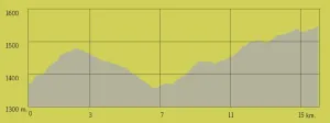
PERFIL DE ALTURAS

MORE INFORMATION
TUNNELS
STEEL VIADUCTS
METAL WALKWAYS
WATER POINTS
PONTOONS
GUARD BOOTHS AND BARRIERS
SWITCHMAN'S CABINS
CYCLABILITY
RECREATIONAL OR SPORTS AREAS NEAR THE TRAIL
AID STATIONS
LINKS TO OTHER TRAILS
SHELTERS
RECOMMENDATIONS
OTHER INFORMATION OF INTEREST (ARCHITECTURAL OR HISTORICAL-CULTURAL, GEOLOGICAL-ECOLOGICAL)
Technical Description
This route begins at the LINAREJOS VIEWPOINT, from where you can enjoy an excellent panoramic view of much of the Sierra de Cazorla, one of the mountain ranges that make up the Natural Park. The renowned naturalist and great admirer of these landscapes filmed countless scenes very close to this location. During the winter months, you can hear the sound of the water plunging down the nearby Linarejos Stream waterfall. In addition to the “Félix Rodríguez de la Fuente Viewpoints” Route, there are other equally interesting routes nearby that allow visitors to discover more of this magnificent Natural Park, such as Cerrada de Utrero and the Linarejos Viewpoint Route.
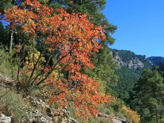
The second VIEWPOINT included on this route is POYOS DE LA MESA, which offers one of the most spectacular panoramic views in the Sierras de Cazorla, Segura y Las Villas Natural Park: the Poyos de la Mesa plateau, which reaches an altitude of 1,635 metres. Should you decide to climb it, you will enjoy breathtaking views of the Guadalquivir Valley, Vadillo-Castril and the El Adelantado Parador, among other places. It is a geological formation highly characteristic of these mountains: a unique high plateau that ends in a steep descending slope. Among the pine forests near this point stands the Pino Abuelo, or Grandfather Pine, one of the oldest trees in the area.
Coordinates: 37.906835,-2.913155
The third VIEWPOINT on the route is NAVA DE SAN PEDRO, where the meadows were once converted into vegetable gardens and cultivated fields. It provides an insight into living conditions at a time when timber was one of the main resources extracted from the mountains and the inhabitants used the relatively scarce open spaces for livestock farming and agriculture. On many occasions, the forest rangers themselves established forest houses in suitable locations such as this one, where vegetable gardens and small-scale livestock farming supplemented both their diet and their income. From this viewpoint, you can enjoy impressive views and learn about the return of the bearded vulture to Andalusia.
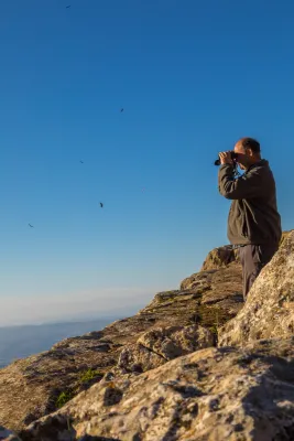
The landscape before you was the last Andalusian refuge of an animal as little known as it is spectacular: the bearded vulture. This Iberian vulture disappeared from the mountains you are now looking at in the late 1980s, resulting in its extinction in Andalusia.
Shortly afterwards, work began on the programme to reintroduce the bearded vulture to Andalusia, promoted by the Regional Ministry of the Environment. The species’ most remarkable characteristic is its scavenging diet, as it is the only bird on the planet that feeds almost exclusively on bones. To do so, it has developed an ingenious behaviour from which it takes its name: it drops bones from great heights so that they break against the ground in places known as bone-breaking sites. This allows it to consume large, hard bones. Although the bird is harmless, all the threats faced by bearded vultures are associated with human beings and their activities.
Their populations declined and became locally extinct as a result of direct persecution, collecting, collisions and electrocution involving power lines, and the illegal use of poisoned bait.
Today, they are also affected by disturbance around nesting sites caused by nearby recreational activities such as climbing and paragliding, as well as by reduced food availability and the decline of extensive livestock farming.
To achieve the return of the bearded vulture to Andalusia, feasibility studies were carried out to identify the most suitable areas for the species. A captive-breeding programme was established to provide chicks for reintroduction, together with a release and monitoring plan and a public-awareness programme aimed at informing the sectors involved in its conservation.
The fourth stop has been named the BARRANCO DEL GUADALENTÍN VIEWPOINT, where you can clearly observe the course followed by the river on its way towards the nearby La Bolera Reservoir. Over the centuries, the Guadalentín River has carved an impressive valley through the hard rock, which later narrows into secluded gorges known locally as “cerradas”. From here, the Sierra del Pozo rises majestically, containing some of the highest peaks in the Natural Park, including Pico Cabañas, which stands at over 2,000 metres and dominates the mountain landscape. At the foot of the viewpoint lies the path of the “Félix Rodríguez de la Fuente Viewpoints” Route, which climbs continuously until reaching the end of this magnificent route at the Estrecho de los Perales.
The fifth stop is the ESTRECHO DE LOS PERALES VIEWPOINT, a remarkable gorge distinguished by the beauty of its unusual rock formations. Below, the Valdetrillo Stream tumbles through lively rapids, providing a pleasant natural soundtrack. In this area, you may see agile mouflons and male Iberian ibex climbing the vertical rock faces, or enjoy the majestic flight of a golden eagle, griffon vulture or booted eagle. Behind the viewpoint stands Cerro de los Trancos, which offers views of some of the highest mountains in this protected natural area, including El Cabañas.
“We must do everything within our power; we must fight together, united and tenaciously, so that a vast, round rock does not die: a rock with a heart of iron and basalt, a rock with a skin of water and clouds, a rock whose voice is the singing of birds and the whisper of the breeze, now increasingly overwhelmed by the roar of the machines invented by humankind; a rock travelling through space, carrying the human species and every living animal; a rock that I like to call the blue planet.”
Félix Rodríguez de la Fuente in El Hombre y la Tierra.