




Recreational Area Río Cuadros – Caño del Aguadero
Description
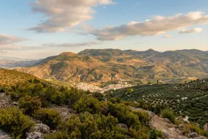
A journey that links the Recreative Area of the Cuadros River with Bélmez de la Moraleda, ascending between pinars and thunderheads until the Caño del Aguadero and the high slopes of Magina. The tour combines forest slopes and half-mountain trails, with wide views over the valley of the Cuadros River and the Garganton Barrio, to end up coming down between olive groves and gardens towards the urban town of Bélmez.
Is part of

Datos de la ruta
ROUTE NAME
Área Recreativa Río Cuadros – Caño del Aguadero
TRAIL TYPE
--
DIFFICULTY
Alta
TOTAL DISTANCE (IN KILOMETERS) 21,1 km
-
Stretch of asphalt or concrete:
-
Section of track, forest road, or dry watercourse:
-
Trail section:
-
Sections of livestock trails:
HUSO 30S
ESTIMATED TRAVEL TIME
ROAD SURFACE TYPE
MAXIMUM ELEVATION CHANGE 1317mm
--
--
DIFFICULTY. RATING ACCORDING TO THE MIDE METHOD
--
MEANS
Severity of the natural environment
--
ITINERARY
Route guidance
--
DISPLACEMENT
Difficulty moving about
--
EFFORT
Amount of effort required
ACCESSIBILITY TYPE
TIME OF YEAR
SIGNALING
No
MORE INFORMATION
TUNNELS
STEEL VIADUCTS
METAL WALKWAYS
WATER POINTS
PONTOONS
GUARD BOOTHS AND BARRIERS
SWITCHMAN'S CABINS
CYCLABILITY
RECREATIONAL OR SPORTS AREAS NEAR THE TRAIL
AID STATIONS
LINKS TO OTHER TRAILS
SHELTERS
RECOMMENDATIONS
OTHER INFORMATION OF INTEREST (ARCHITECTURAL OR HISTORICAL-CULTURAL, GEOLOGICAL-ECOLOGICAL)
Technical Description
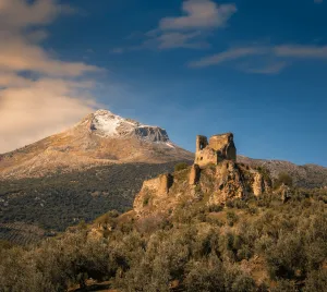
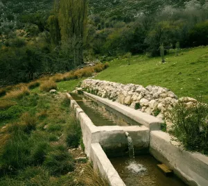
A serene and balanced route that runs through one of the most unique river landscapes of Sierra Mágina, from the south of the Cuadros River to the Caño del Aguadero, then to Búlmez de la Moraleda. A itinerary where water, geology and rural memory are combined in a comfortable layout, designed to enjoy without haste. The tour begins in the Recreative Area of the River Cuadros, in the surroundings of Bedmar, entrance door to an exceptional thinning, one of the best preserved and most extensive of the southern peninsular. From the first steps, the path runs next to the channel, between walkways, limestone slopes and riverside shade, with the constant rumor of water marking the rhythm. The route gently ascends through the valley following the main route, shared in the start with the C5 cycloturist route, while the river accompanies between galleries of adelfas, willows and fig trees. The landscape reveals its fluviokarctic character: limestone walls, rocky highlights and small throats modeled by the discharge of the Cárceles-Carluca aquifer, which feeds the springs of the area. The central point of the itinerary is the Caño del Aguadero, a cold and constant spring that sprouts at the foot of the limestone and gives life to the valley even in the driest months. It is an ideal place to stop, read the landscape and recognize the peaks of Magina that are cut on the horizon. From here, the route changes from the side to the Garganton Valley, starting a progressive descent with open views of olive groves and pine trees. Before reaching Bélmez, a short detour allows you to look at the hill of the Torre del Lucero, an ancient medieval atalaya that watched the steps of the Jandulilla and maintained visual contact with the castle of Bélmez de la Moraleda. The final section descends through clear paths between burning and open lomas until entering the urban centre, where the route ends. It is a tour that invites you to understand how the water structure the territory, from the saw to the gardens, and to walk calmly through a living and worked landscape for centuries. General recommendations Route suitable for walking trails. See the weather, especially after rain, when springs can increase their flow. Use shoes with good grip in wet sections and respect the riverside environment and springs, avoiding getting out of the trail. It has enough water, although you will find seasonal sources on the tour.


