Scenic Drive Mogón Charco del Aceite
Description
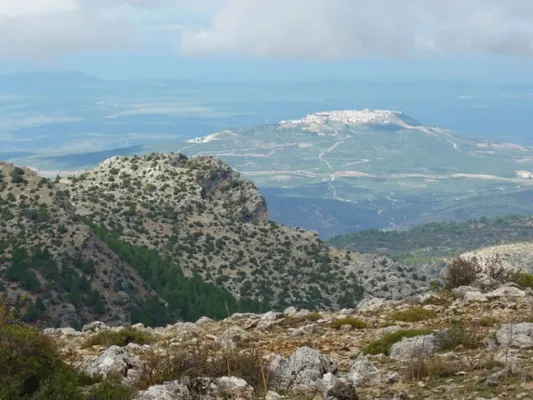
The winding and winding route of this road, which is perfectly framed in this beautiful environment, will discover a part of this unexplored and almost unknown paradise and will show us many landscapes of a prodigious beauty, where water is often the protagonist.
We will find numerous cortijos, some standing and others in ruins, faithful examples of popular architecture. As we advance our journey, we are shown forests of majestic pine trees, authentic sabinars, dense riverside forests in the streams and centuries-old examples of oak trees and complaints.
Is part of

Datos de la ruta
ROUTE NAME
Ruta en coche Mogón Charco del Aceite
TRAIL TYPE
Scenic Drive
DIFFICULTY
--
TOTAL DISTANCE (IN KILOMETERS) 60 km
-
Stretch of asphalt or concrete:
-
Section of track, forest road, or dry watercourse:
-
Trail section:
-
Sections of livestock trails:
HUSO 30S
ESTIMATED TRAVEL TIME
ROAD SURFACE TYPE
Forest track
--
--
DIFFICULTY. RATING ACCORDING TO THE MIDE METHOD
--
MEANS
Severity of the natural environment
--
ITINERARY
Route guidance
--
DISPLACEMENT
Difficulty moving about
--
EFFORT
Amount of effort required
ACCESSIBILITY TYPE
By car, on foot
TIME OF YEAR
All year round
SIGNALING
No
MORE INFORMATION
TUNNELS
STEEL VIADUCTS
METAL WALKWAYS
WATER POINTS
PONTOONS
GUARD BOOTHS AND BARRIERS
SWITCHMAN'S CABINS
CYCLABILITY
RECREATIONAL OR SPORTS AREAS NEAR THE TRAIL
AID STATIONS
LINKS TO OTHER TRAILS
SHELTERS
RECOMMENDATIONS
The use of all-terrain vehicle is recommended if we move away from the road.
OTHER INFORMATION OF INTEREST (ARCHITECTURAL OR HISTORICAL-CULTURAL, GEOLOGICAL-ECOLOGICAL)
Technical Description
1. Km 0. Mogón. This beautiful village, which belongs to the municipality of Villacarrillo, lies in the Guadalquivir Valley. Its olive groves and fertile river plains are also watered by the Aguascebas River, as both waterways converge at this point. It has a large, well-equipped bathing area in the “El Molinillo” beauty spot.
2. Km 9.9. La Osera and Cerro Vilorto Viewpoints. On our left are these two viewpoints, offering magnificent panoramic views of La Osera, one of the most iconic natural areas in these mountains.
3. Km 14. Curva del Tambor. Its name comes from its pronounced circular layout. From here, looking eastwards, there are extensive views over the Cañamares River Valley, the waterfall and the vulture nesting site at Peña Palomera, as well as the villages of Cazorla, La Iruela and Burunchel.
4. Km 18.5. Chorrogil Waterfall. Approximately 500 metres before reaching the Aguascebas Reservoir, a dirt track begins on the right-hand side and leads us close to this spectacular horsetail-shaped waterfall. Among the lush vegetation are several birch trees, a northern species whose presence at this latitude is truly exceptional. Its multicoloured rock face makes the area even more attractive.
5. Km 19. Aguascebas Reservoir. This charming artificial lake supplies drinking water to the villages throughout La Loma. It is also a high-mountain rainbow trout fishing reserve. Bathing is not permitted.
6. Km 22. La Fresnedilla. This is the main hub of this part of the Sierra de las Villas. It is a small village equipped with a primary school and a municipal hostel. Around 700 metres from this point, several tracks branch off to the left, providing access to charming places that are well worth exploring on foot, such as Arroyo del Torno, Nava del Milano and the summit of Navazalto.
7. Km 24. Collado del Lobo, Nava del Rico and Collado del Pocico. A particularly distinctive type of vegetation catches our attention here: the juniper woodland. Magnificent specimens of Phoenician juniper occupy the limited soil between the limestone rocks at Lancha del Sabinar. On our right, a track provides access to beautiful places such as Cruz de Juan Núñez, Cortijo de la Cruz, Las Castañetas and Prado de los Chopos.
8. Km 28. Cerrada de San Ginés. On our right begins the track that provides access to the highest areas of this remarkable mountain range and brings us closer to this natural site. The waters of the small Aguascebas de Gil Cobo River flow through the canyon, alternating between distinctive waterfalls and refreshing pools. The first section of this area is well worth exploring on foot, both for its undeniable beauty and for its extraordinary botanical wealth, which includes numerous endemic species and specimens of yew, holly and birch. The Gil Cobo Recreational Area is located just a few metres from the beginning of this forest track.
9. Km 34.5. Cueva del Peinero. A recreational area located in a setting of majestic beauty beside the Aguascebas Grande River, whose waters flow through lush riverside vegetation and between large stone blocks.
10. Km 40. Collado del Ojuelo. This location is a crossroads. To the left, the forest track leads to places such as Collado de la Tobilla, La Muela and Cañada de la Madera. To the right, the Tableros track, which is closed to vehicles by a barrier, provides access to lesser-known locations such as Prado de los Chortales, Cañada Somera, Collado de los Hermanillos and Caballo de Torraso.
11. Km 47. Agua de los Perros. This spectacular site is dominated by the enormous dome known as Iglesia de los Perros. Its centre is pierced by an opening resembling a skylight, through which the stream that flows into it falls like fine raindrops. At Piedra del Agujero there is an enormous opening carved into the rock by erosion, as well as a natural bridge shaped in the rock by the stream. Visitors can cool down at its spring of cold, crystal-clear water.
12. Km 48. Collado del Agua de los Perros. At an altitude of 1,200 metres, this location is well worth a stop to admire the views, the pine forests and the beautiful specimens of Spanish juniper.
13. Km 50. Mirador del Tapadero. An essential stop at this viewpoint overlooking the abyss. Below, the narrow and turbulent course of the Chillar Stream can be seen.
14. Km 55.4. Fuente de los Cerezos Regulated Campsite. Beside the road stands a beautiful fountain with two spouts. Near this location, approximately 300 metres to the right, beside the first stream, we can see one of the few surviving tar kilns, traditionally used to extract juniper tar, that remains fully intact within the Natural Park. It is a silent reminder of how people once made use of the natural resources of these mountains.
15. Km 58.2. Puente de los Agustines – Charco del Aceite. After crossing the bridge over the Guadalquivir River, a short turning on our right leads to a delightful bathing area. The Charco del Aceite Recreational Area is a natural setting where the Guadalquivir forms a large pool of clean, refreshing water.