Route Gil Cobo - Fuente Colorá
Description
If you access from Chilluévar and about 8 km away. after passing the reservoir of the Aguascebas, in the km. 28, there is a secondary forest track or road that leaves to the right of the road, just where it crosses the Arroyo de las Aguascebas de Gil Cobo, beginning of the route.
Is part of

Datos de la ruta
ROUTE NAME
Campamento de Gil Cobo a Cortijos del Pardal
TRAIL TYPE
Circular
DIFFICULTY
--
TOTAL DISTANCE (IN KILOMETERS) 11,3 km (solo ida)
-
Stretch of asphalt or concrete: 0
-
Section of track, forest road, or dry watercourse: 0.01
-
Trail section: 0
-
Sections of livestock trails: 0
HUSO 30S
30S x = 508418 and = 4209450
ESTIMATED TRAVEL TIME
ROAD SURFACE TYPE
Sandy and rocky
ELEVATION CHANGE
476mm
279mm
DIFFICULTY. RATING ACCORDING TO THE MIDE METHOD
--
MEANS
Severity of the natural environment
--
ITINERARY
Route guidance
--
DISPLACEMENT
Difficulty moving about
--
EFFORT
Amount of effort required
ACCESSIBILITY TYPE
TIME OF YEAR
All year round
SIGNALING
No
PERFIL DE ALTURAS

MORE INFORMATION
TUNNELS
STEEL VIADUCTS
METAL WALKWAYS
WATER POINTS
PONTOONS
GUARD BOOTHS AND BARRIERS
SWITCHMAN'S CABINS
CYCLABILITY
RECREATIONAL OR SPORTS AREAS NEAR THE TRAIL
AID STATIONS
LINKS TO OTHER TRAILS
SHELTERS
RECOMMENDATIONS
OTHER INFORMATION OF INTEREST (ARCHITECTURAL OR HISTORICAL-CULTURAL, GEOLOGICAL-ECOLOGICAL)
Technical Description
The path begins in the recreational area and camp of Gil-Cobos by the right margin of the stream of the Aguascebas, up the secondary forest track that exists there in a southeast direction. At 800 m from the beginning we find one of the most beautiful areas of this tour, the Cerrada de San Ginés, a vertical setting of rocky lanterns formed by the Lobo's Locks on the left, and the Escalera's boat on the right, which is surrounded by deciduous forests, pinars, and riparian and rupic communities.
At the end of it, where the stream is divided into two, the track is also divided and we will have to turn right according to the direction of the march, to continue a steep rise in its first meters; after a sharp curve we find a source of work with some stone tables, it is Fountain Colorá, at 2.1 km. From the beginning. 600 meters later we find on our left a shop, it is Majalserbal, which is raised on the beautiful and agribusiness boat Ignacio. The other boat, which falls from the ink to the beginning of the Cerrada de San Ginés, has the name "Lancha del Sordo."
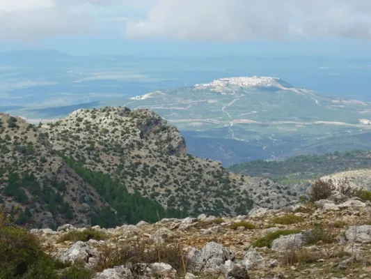
After walking 4.4 km. We got to a collar. We are at the top of the Stairboat. The Poyo of the Robles is what is also called all this land. Large panorama of the lome of Ubeda with several well-visible villages and the massif of Sierra Magina. We are close to 1,600 m of altitude and vegetation is characteristic of the high mountain of the Park, piornal and other small-scale, arbustive and thorny plants, as well as herring, larice pines and some oaks.
This area will be the highest of our journey, as from here we begin to descend. The track tracks several curves with firm formed of loose stones and quite bumpy until it enters the flat lands of Jabalhora. A unique karctic landscape that will accompany us until the end of our journey. We found several streams on its highest side, such as Arroyo del Raso de la Escalera and Arroyo de la Fuente del Tejo, and in the km. 6.7 and also a jungle with water called the Fuentecilla of the Vultures.
Later, in the km. 8.2, we left a track to the left, which is directed to other cortijadas in the Avellano Canyon or Jabalhora cortijos also called. We will continue to the left to find in the km. 8.8 The cords of the Berraza, where there is a source. From this moment on the firm becomes more difficult and begins to turn right to leave Peña Corba to our left.
At 11.3 km. We got to the Pardal Cortijos. It is recommended to climb to the peak on foot, as with its 1.578 m., it offers a wide view of the area. The return will be on the same way out.