



Cerro Golondrina
Description
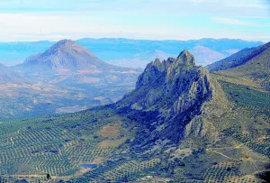
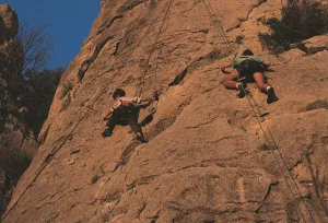
It is a very bright wall, which is integrated into an interesting relief formation and surrounded by a landscape with magnificent views. It is located at the limits of the Natural Park of Sierra Magina. Although it is a school of local interest, it may be of interest for a short visit. His inclination is quite vertical. The insurance system allows sports climbing with a certain technical character. The limestone walls reach 25 meters of level, with an average height of 15 meters.
Is part of

Datos de la ruta
ROUTE NAME
Cerro Golondrina
TRAIL TYPE
--
DIFFICULTY
--
TOTAL DISTANCE (IN KILOMETERS) --
-
Stretch of asphalt or concrete:
-
Section of track, forest road, or dry watercourse:
-
Trail section:
-
Sections of livestock trails:
HUSO 30S
30S x = 470026 and = 4185186
ESTIMATED TRAVEL TIME
ROAD SURFACE TYPE
Road
--
--
DIFFICULTY. RATING ACCORDING TO THE MIDE METHOD
--
MEANS
Severity of the natural environment
--
ITINERARY
Route guidance
--
DISPLACEMENT
Difficulty moving about
--
EFFORT
Amount of effort required
ACCESSIBILITY TYPE
TIME OF YEAR
SIGNALING
No
MORE INFORMATION
TUNNELS
STEEL VIADUCTS
METAL WALKWAYS
WATER POINTS
PONTOONS
GUARD BOOTHS AND BARRIERS
SWITCHMAN'S CABINS
CYCLABILITY
RECREATIONAL OR SPORTS AREAS NEAR THE TRAIL
AID STATIONS
LINKS TO OTHER TRAILS
SHELTERS
RECOMMENDATIONS
OTHER INFORMATION OF INTEREST (ARCHITECTURAL OR HISTORICAL-CULTURAL, GEOLOGICAL-ECOLOGICAL)
Number of routes:16
You're up to V:60%
Votes from V + to 6c +:40%
Vies from 7a to 7c +:0%
Eight-way:0%
Best time:spring and autumn
Technical Description
For water, food and accommodation.- Water should be brought, as the nearest water is in Bedmar or Jodar. The accommodation and restaurants of the immediate villages are ideal for finding supply.
How to get there.- The area is 60 kilometres from Jaén capital. From this city you have to go to Bedmar (C-328). After that municipality we turn right through the crossing with the C-325. We arrived shortly after the area. The walls have no loss. They get up in the middle of the hill. There's enough space to park on both sides of the road.


