

Description
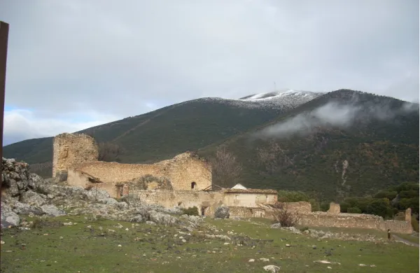
Cambil, located in a large valley south of Sierra Mágina, is surrounded by high peaks and thick mountains. Cambil has two large rocks, almost vertical murallions of Marchesian limestone separated by a cut carved by the Villanueva River, where the Muslim castles of Cambil and Alhabar were located, whose origin is related to the border of the Nazari Kingdom of Granada in 1246. The castle of Alhabar is located in the rocky farallon of the same name located to the east of the river, while the castle of Cambil occupies the entire plateau of the peñasco of the same name, to the west of the river.
The Castle of Alhabar, occupies the entire upper plateau of the farallon of the east bank of the river. It was of small proportions but of a higher size than the castle of Cambil, of rectangular floor and adapted to the rock steep by two of its sides (north and south), against which it raised its wall, on the east and west facades, of which remains of very damaged structures.
In the inner space it is worth noting the existence of two levels that were enhanced by human work: a central one that makes the times of alcazareño and another peripheral. The visible work inside the castle is of small and abundant plaster mortar.
Access to the castle was made in the west by a narrow entrance preceded by a very long staircase, very narrow, partially carved on the rock, so it was not accessible for riding. At this point the space was closed with a wall of bulkhead.
The other wall lock, the east lock, is very restored to avoid collapse. Near this, at the top of the rib in which the hill seems to be nailed, there are signs of a rectangular construction, probably the only living space of Alhabar.
A lookout has now been enabled from the castle of Alhabar, from where you can see the field of vision that was held at that time from the castle.
The Cambil Castle, occupied the entire top plateau, approximately rectangular, of the rocky pharallion on the west bank of the river. It had natural defenses on three of its fronts, protected only by a small parapet, due to the steep nature of the rock on which it settled, only the west side has a low level of about 4 or 5 meters, so on this side it was where it had some kind of fortification and where the castle should be accessed.
The interior of the castle is rather rough, with small masonry and a lot of plaster mortar. It was structured on two levels: one central as an alcazarejo, and the other peripheral.
The alcazarejo is formed by an overheated plateau that was surrounded by parapets and perhaps leveled with land. In the eastern sector, a tight structure is detected that supports and enhances it, two walls of bulkhead at a right angle with the corner formed by a chain of very narrow and well-cut chairs.
The inner space from which we could call the courtyard of weapons, was divided into two longitudinal sectors by a divisive of dry bulkheads, today completely melted although their stones are in situ.
The remains of the pond, carved on the living rock, reveal the entrance of the castle. In some areas of the castle there are stone bowls, which, because of their dispersion, could be remnants of the bombing carried out in 1485 by the Catholic Kings.
Today, remains of the wall can still be seen.
Is part of