


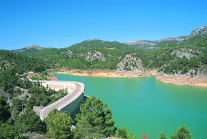

Hiking Route Aguascebas de Gil Cobo and subida al Blanquillo
Description
The wide road enters the San Ginés closed, parallel to the stream. The channel has been capriciously modeled by the action of water, giving rise to unique jumps and small water pods. Some sections are flanked by abrupt rocky brown. On its shores we find an exceptional vegetation with various endemic species, as well as tides, stalks and even some birches, a purely northern and very scarce tree in the Natural Park.
We continue as far as the track forks and follow our left, accompanied by magnificent pinars. The sinuous route of the road allows us a smooth rise to the Collado del Perenoso, where we have a spectacular view of this whole environment. This is the starting place towards the peak of the Blanquillo or Pedro Miguel.
The tour here has plenty of attractive to do, but if we want stronger emotions, we can ascend to this extraordinary summit. We take to our right a narrow path that runs through a soft hill between salgarean pines in its first stretch.
We continue along this path, through a small ledge that diagonally crosses a rocky wall, and with great caution we pass some sections that have some difficulty. We follow the path, passing a stream that descends from the summit, and we reach a small plain, which is named "La Carrasquilla," from where we see the dominant limestone mole, the modesty vegetation of the high mountain and the shaded pine trees that indicate the extreme weather conditions of this place.
From here we see the final section of this route. We will head towards a small hill and from there we follow the rope, where the arrival to the top is more serene. Once at the summit we have before us all the immensity and beauty of these unusual places.
Is part of

Datos de la ruta
ROUTE NAME
Ruta de senderismo Aguascebas de Gil Cobo y subida al Blanquillo
TRAIL TYPE
--
DIFFICULTY
--
TOTAL DISTANCE (IN KILOMETERS) --
-
Stretch of asphalt or concrete:
-
Section of track, forest road, or dry watercourse:
-
Trail section:
-
Sections of livestock trails:
HUSO 30S
ESTIMATED TRAVEL TIME
ROAD SURFACE TYPE
Forest Track and Trail
--
--
DIFFICULTY. RATING ACCORDING TO THE MIDE METHOD
--
MEANS
Severity of the natural environment
--
ITINERARY
Route guidance
--
DISPLACEMENT
Difficulty moving about
--
EFFORT
Amount of effort required
ACCESSIBILITY TYPE
On foot
TIME OF YEAR
All year round
SIGNALING
No
MORE INFORMATION
TUNNELS
STEEL VIADUCTS
METAL WALKWAYS
WATER POINTS
PONTOONS
GUARD BOOTHS AND BARRIERS
SWITCHMAN'S CABINS
CYCLABILITY
RECREATIONAL OR SPORTS AREAS NEAR THE TRAIL
AID STATIONS
LINKS TO OTHER TRAILS
SHELTERS
RECOMMENDATIONS
Once at the top, approach the pinar that is observed to the north, known as Black Pinar. It is a forest made up of centenary and unique examples of salgarean or laritian pine trees (Pinus nigra ssp. salzmanii), in which there is a small fountain with its wooden tornachs, which the mountain-flocks use as a watershed.
The possibility to make the descent through the rope in a southwestern direction towards the hill of White Water and descent through the vaguada, towards the main track of the Cerrada San Gines.
OTHER INFORMATION OF INTEREST (ARCHITECTURAL OR HISTORICAL-CULTURAL, GEOLOGICAL-ECOLOGICAL)
Technical Description
Forest track that starts at km 28 of the JH-1755 (Transversal de las Villas) road, to the right, right next to the river Aguascebas de Gil Cobo, very close to Recreative Area of the same name.


