

Trail Veredón-Mojón Blanco
Description
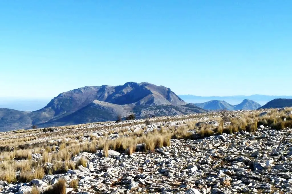
The path from the Veredón to Mojón Blanco runs along the Pecuaria route Colada Fuente de la Teja, in Pegalajar. It allows us to climb to the peak in which the municipal terms of Pegalajar, Mancha Real and Torres are joined, and from which are seen spectacular views of the Bercho umbria, one of the most steep and wild areas of the municipal term Pegalajar. We can also enjoy amazing views of the Sierra de Jaén.
It is a relatively short path that we can complete with a visit to the beautiful village of Pegalajar and its famous pond, which in the years of abundant rains appears as a huge pond within the urban centre.
This path can be linked to those who come from the Royal Mancha, as well as other pecuary ways, or even, to the Pico Almadén.
Is part of

Datos de la ruta
ROUTE NAME
Sendero Veredón-Mojón Blanco
TRAIL TYPE
Linear
DIFFICULTY
Media
TOTAL DISTANCE (IN KILOMETERS) 2,9 km
-
Stretch of asphalt or concrete:
-
Section of track, forest road, or dry watercourse:
-
Trail section:
-
Sections of livestock trails:
HUSO 30S
ESTIMATED TRAVEL TIME
1 h 30 min
ROAD SURFACE TYPE
Trail
--
--
DIFFICULTY. RATING ACCORDING TO THE MIDE METHOD
--
MEANS
Severity of the natural environment
--
ITINERARY
Route guidance
--
DISPLACEMENT
Difficulty moving about
--
EFFORT
Amount of effort required
ACCESSIBILITY TYPE
On foot
TIME OF YEAR
All year round
SIGNALING
No
MORE INFORMATION
TUNNELS
STEEL VIADUCTS
METAL WALKWAYS
WATER POINTS
PONTOONS
GUARD BOOTHS AND BARRIERS
SWITCHMAN'S CABINS
CYCLABILITY
RECREATIONAL OR SPORTS AREAS NEAR THE TRAIL
AID STATIONS
LINKS TO OTHER TRAILS
SHELTERS
RECOMMENDATIONS
- In front of COVID19, keep the safety distance and carry a mask, avoid agglomerations and contact with surfaces, wash your hands frequently, use hydroalcoholic gel and consult the available digital materials. Take care of your health and others.
- It works to prevent fires. Do not throw cigarettes or any other object that produces combustion.
- By consuming local products and having companies in the area you will contribute to rural development.
- He lives with the local people and other users. It respects private property and property.
- Unwind in a sustainable way: public transport, bike, walk, shared vehicle...
- Noise is another form of pollution. In silence you will enjoy your experience more.
- It facilitates the use of people with special needs.
- The trash doesn't come back alone. Take her with you to the nearest container. Reduce, reuse, recycle.
- Don't leave a mark on your way through nature.
- It practices a responsible and committed tourism with the environment. Be a real ecotourist!
- Respect the facilities at your disposal. We all pay for your maintenance.
- Check the weather forecast before starting your activity.
- Avoid going out alone. If you do, it communicates tour and time of return to other people.
- Extreme caution under adverse conditions and with the occasional presence of animals or motor vehicles.
- Please provide prior information on the possible existence of cynegetic activity.
- It has water, sun protection, proper clothes and shoes.
- It carries a mobile with enough battery in case of emergency (112), but remember that there is not always coverage.
- Don't even bother animals. You would negatively alter his behavior.
- For your safety and the safety of the environment, don't get out of the signposted road or take shortcuts.
- Remember that the capture of animals, light fire, fish and collect plants or minerals is prohibited.
- If you bring a dog, take him with his strap and make sure he doesn't bother other animals or people.
- Your safety is our concern, but it's your responsibility.
Thank you for your cooperation!
OTHER INFORMATION OF INTEREST (ARCHITECTURAL OR HISTORICAL-CULTURAL, GEOLOGICAL-ECOLOGICAL)
Technical Description
The path from the Veredón to Mojón Blanco runs along the Pecuaria route Colada Fuente de la Teja, in Pegalajar. It allows us to climb to the peak in which the municipal terms of Pegalajar, Mancha Real and Torres are joined, and from which are seen spectacular views of the Bercho umbria, one of the most steep and wild areas of the municipal term Pegalajar. We can also enjoy amazing views of the Sierra de Jaén.
It is a relatively short path that we can complete with a visit to the beautiful village of Pegalajar and its famous pond, which in the years of abundant rains appears as a huge pond within the urban centre.
This path can be linked to those who come from the Royal Mancha, as well as other pecuary ways, or even, to the Pico Almadén.