


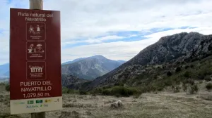


Route Natural del Puerto de Navatrillo
Description
It is a circular route that runs along rural roads and trails of the municipality.
Datos de la ruta
ROUTE NAME
Ruta Natural del Puerto de Navatrillo
TRAIL TYPE
Circular
DIFFICULTY
Media
TOTAL DISTANCE (IN KILOMETERS) 7,7 km
-
Stretch of asphalt or concrete:
-
Section of track, forest road, or dry watercourse:
-
Trail section:
-
Sections of livestock trails:
HUSO 30S
ESTIMATED TRAVEL TIME
3 h
ROAD SURFACE TYPE
Road
--
--
DIFFICULTY. RATING ACCORDING TO THE MIDE METHOD
--
MEANS
Severity of the natural environment
--
ITINERARY
Route guidance
--
DISPLACEMENT
Difficulty moving about
--
EFFORT
Amount of effort required
ACCESSIBILITY TYPE
TIME OF YEAR
All year round
SIGNALING
No
MORE INFORMATION
TUNNELS
STEEL VIADUCTS
METAL WALKWAYS
WATER POINTS
PONTOONS
GUARD BOOTHS AND BARRIERS
SWITCHMAN'S CABINS
CYCLABILITY
RECREATIONAL OR SPORTS AREAS NEAR THE TRAIL
AID STATIONS
LINKS TO OTHER TRAILS
SHELTERS
RECOMMENDATIONS
- Use comfortable shoes and dress suitable for the time of year.
- Hold on to water.
- Always go with another or other hikers.
- Calculate your route to complete before sunset.
- In case of an accident, call the emergency number 112.
OTHER INFORMATION OF INTEREST (ARCHITECTURAL OR HISTORICAL-CULTURAL, GEOLOGICAL-ECOLOGICAL)
Technical Description
It is a circular route that runs along rural roads and trails of the municipality. Its starting point is on the Valdepeñas road, on the access lane to La Urbanización La Carrasquilla (Los Torcales lane). To the point of kilometric 3,300, the stretch is shared with the Natural Route of the Sierra, ending at the starting point. Arriving at the port of the Navatrillo, we go down to the Dark Cave and, through the Llano de los Propios, we can access the cave of the Contadero. Then we'll go down a lane to Los Villares. To highlight the impressive views of the Cave of the Contadero, which allow to appreciate to our right Jabalcuz, to the background the rock of Castro and the Sierra la Grana, to the front of the Mount Wind and to the left the Pandera, as well as a fantastic panoramic of the village.


