

Route de los Nazaríes
Description
The historical, monumental and landscape heritage is united in this path, which is marked by the endless succession of the castles and atalayas that constituted the impressive defensive system that both Muslims and Christians built, as these lands continued to pass from one hand to another during the 13th to 15th centuries. Part of the Navas de Tolosa and runs through the lands from which Nasar House, founders of the Nazi dynasty, originated.
https: / / www.andalucia.org / es / rutas-ruta-de-the-nazaries
Is part of

Datos de la ruta
ROUTE NAME
Ruta de los Nazaríes
TRAIL TYPE
--
DIFFICULTY
--
TOTAL DISTANCE (IN KILOMETERS) --
-
Stretch of asphalt or concrete:
-
Section of track, forest road, or dry watercourse:
-
Trail section:
-
Sections of livestock trails:
HUSO 30S
ESTIMATED TRAVEL TIME
ROAD SURFACE TYPE
--
--
DIFFICULTY. RATING ACCORDING TO THE MIDE METHOD
--
MEANS
Severity of the natural environment
--
ITINERARY
Route guidance
--
DISPLACEMENT
Difficulty moving about
--
EFFORT
Amount of effort required
ACCESSIBILITY TYPE
TIME OF YEAR
All year round
SIGNALING
No
MORE INFORMATION
TUNNELS
STEEL VIADUCTS
METAL WALKWAYS
WATER POINTS
PONTOONS
GUARD BOOTHS AND BARRIERS
SWITCHMAN'S CABINS
CYCLABILITY
RECREATIONAL OR SPORTS AREAS NEAR THE TRAIL
AID STATIONS
LINKS TO OTHER TRAILS
SHELTERS
RECOMMENDATIONS
OTHER INFORMATION OF INTEREST (ARCHITECTURAL OR HISTORICAL-CULTURAL, GEOLOGICAL-ECOLOGICAL)
Technical Description
The starting point of this route is located in the Navas de Tolosa, where the decisive departure that made it possible to open Andalusia to Christianity was won. The route is built through vigorous landscapes in the town of La Carolina and in ancient fortified villas like Baños de la Encina, with its califal-era castle, in historic crossroads of roads like Bailén or Mengibar and in large cities like Andújar, surrounded by the nature of its natural park.
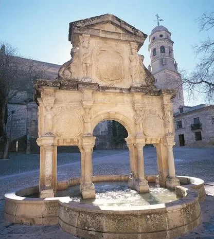
The itinerary is held in the municipalities of the western countryside of Jaén: Arjona, Porcilla, Torredonjimeno, Martos, Torredelcampo, synonyms of border squares, monumental enclosures and industrial villas with oil as protagonist. Then the route goes back to the course of the high Guadalquivir, approaching Linares, to follow the region of La Loma. Here are two unique jewels: Baeza and Ubeda. Two Renaissance sets, unparalleled tops of the history and art of Andalusia.
From here on, the Sierra Magina road through Jódar and its fortress, Jimena and Mancha Real, until entering Jaén, head of Holy Kingdom, crowned by the castle of Santa Catalina and the Cathedral. This route then runs through La Guardia de Jaén, through mountains and ports in the direction of Cambil and Huelma, before entering the province of Granada by Guadahortuna, Píñar and Iznalloz. Only the mountains of Sierra Nevada separate us from the one that was cut from the Nazari sultans. In the meantime, the houses of Deifontes, Albolote, Maracena, as predecessors of the destination of the route, stand out: Granada, which is covered by living traditions in which the indelible heritage of the Andalusian civilization is reflected.