





Piscifactoría del Borosa
Description
This route is one of the most classic and frequented of the Natural Park, as it brings together a very attractive landscape dominated by the water of the Tranco reservoir with the possibility of visiting a number of facilities, in which we will enjoy knowing and observing the natural wealth of this protected space. It is mostly due to the winding road A-319, for which it is appropriate to drive with caution, especially on the dates of the greatest tourist influx. You will find various viewpoints and recreational areas in which we recommend stopping you, but below we recommend a series of stops and almost mandatory visits. You will find expanded information from most of these places on this same website.
Datos de la ruta
ROUTE NAME
Piscifactoría del Borosa
TRAIL TYPE
--
DIFFICULTY
--
TOTAL DISTANCE (IN KILOMETERS) --
-
Stretch of asphalt or concrete:
-
Section of track, forest road, or dry watercourse:
-
Trail section:
-
Sections of livestock trails:
HUSO 30S
30S x = 511961 and = 4207528
ESTIMATED TRAVEL TIME
ROAD SURFACE TYPE
Road
--
--
DIFFICULTY. RATING ACCORDING TO THE MIDE METHOD
--
MEANS
Severity of the natural environment
--
ITINERARY
Route guidance
--
DISPLACEMENT
Difficulty moving about
--
EFFORT
Amount of effort required
ACCESSIBILITY TYPE
TIME OF YEAR
SIGNALING
No
MORE INFORMATION
TUNNELS
STEEL VIADUCTS
METAL WALKWAYS
WATER POINTS
PONTOONS
GUARD BOOTHS AND BARRIERS
SWITCHMAN'S CABINS
CYCLABILITY
RECREATIONAL OR SPORTS AREAS NEAR THE TRAIL
AID STATIONS
LINKS TO OTHER TRAILS
SHELTERS
RECOMMENDATIONS
OTHER INFORMATION OF INTEREST (ARCHITECTURAL OR HISTORICAL-CULTURAL, GEOLOGICAL-ECOLOGICAL)
Technical Description
The route is 45 km. It begins in the farm of the Borosa and ends in the Hornos de Segura. It is recommended at least one full day. There are many tourist accommodation on the route.
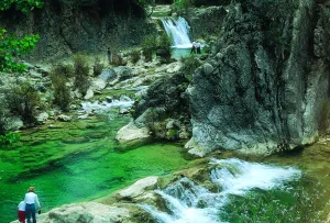
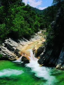
Km 0 - Piscifactory and River Borosa River Interpreting Center. In this Centre we will know the importance of water and river ecosystems in the Natural Park, in which emblematic species such as the common trout and the otter stand out.
Km 1,7 - Vinagre Tower. This area is one of the most crowded in the Park and is located in a geographically privileged area for its centrality. Here it is essential to know the Park Visitors Center, which has been recently modernized and has various interactive resources. It has a Natural Park Store, toilets, cafe, rest room and children's play area on the outside. Very close to this center is the Botanical Garden, a pleasant place with a wide and careful selection of natural park plants, from small herbaceas to large trees. It is a perfect place to observe and learn to distinguish them or simply to take a pleasant walk between lush vegetation.
Km 6.5 - Coto Ríos. This village, on the banks of the Guadalquivir, was built in the 1960s of last century to house families living in scattered villages and cortijos and whose houses were expropriated to create the National Cazorla-Segura Hunting Coto (now the Andaluza de Caza Reserve). It has medical assistance, shops and other services, in addition to several campsites.
Km 13.3 - Wild Fauna Park Collado del Almond. In their enclosure they pasture in semi-freedom deer, mountain goats, wos and muflons. You can see them and photograph them by walking a pleasant itinerary with fountains, banks and several viewpoints with splendid views of the Tranco reservoir and the ruins of the castle of Bujaraiza.
Km 14 - FRF look. It is one of the milestones of the Route of the same name, dedicated to the mythical naturalist Felix Rodríguez de la Fuente, who from this point of view filmed the famous scenes of the berrea of the deer in the 1970s. In front of it is Mount Bujaraiza, which sometimes, when the reservoir is very full, becomes an island, and is crowned by the ruins of an Arab turret.
Km 17.6 - Old-garden controlled area. This place is very nice to eat and rest, except on the dates you are occupied by some camp.
Km 19.2 - House of Crafts Los Casares. It is an old Forest House converted into a shop of crafts and products from the Park.
Km 26 - Old Control Recreative Area. It is a large and recently built area with magnificent views over the northern part of the Tranco reservoir. It has banks, tables to eat and fountain.
Km 28.4 Tranco Dam - This impressive dam, whose height on the Guadalquivir channel is 82 meters, is one of the largest in Spain. In its surroundings there are several restaurants, terraces and water sports facilities, as well as the village that was raised for the workers who built the dam.
Km 31.5 - The Parral Recreative Area. It is in the middle of the carrasco pine pinar and has a look-out with good views over the waters of the Tranco reservoir.
Km 35.7 - Cñada Morales. When it reaches this village the landscape is opened and no longer exclusively forest, to give way to large humanized areas with olive groves, orchards and scattered cortijos.
Km 44.6 - Safe Furnaces. This small town, built on the top of a peñasco, is in the center of the Natural Park. Its monuments, views and irregular alleys of the Arab past, served him the declaration of Artistic Historical Set.


