



Ascent to Pandera
Description
The area has abundant snow wells, used until the 20th century, of which snow was extracted that would then be transformed into ice, to be used for medical purposes and as a water revival.
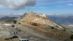
The Alto de La Pandera is a great lookout for the entire Jiennense province and other areas. Thus, in clear sky conditions, it is possible to see Sierra Nevada and the Sierra de Alhama (Granada), the Cordobese subbetic saw, the Ronda serrania and the Málaga Mountains, the Alpujarra almerienne and even Gibraltar.
Datos de la ruta
ROUTE NAME
Subida a la Pandera
TRAIL TYPE
Narrow paved and signposted road.
DIFFICULTY
Alta
TOTAL DISTANCE (IN KILOMETERS) 8,3 km
-
Stretch of asphalt or concrete:
-
Section of track, forest road, or dry watercourse:
-
Trail section:
-
Sections of livestock trails:
HUSO 30S
ESTIMATED TRAVEL TIME
7 h 8 min
ROAD SURFACE TYPE
Road
ELEVATION CHANGE
1217mm
1217mm
DIFFICULTY. RATING ACCORDING TO THE MIDE METHOD
--
MEANS
Severity of the natural environment
--
ITINERARY
Route guidance
--
DISPLACEMENT
Difficulty moving about
--
EFFORT
Amount of effort required
ACCESSIBILITY TYPE
On foot
TIME OF YEAR
All year round
SIGNALING
No
PERFIL DE ALTURAS

MORE INFORMATION
TUNNELS
STEEL VIADUCTS
METAL WALKWAYS
WATER POINTS
PONTOONS
GUARD BOOTHS AND BARRIERS
SWITCHMAN'S CABINS
CYCLABILITY
RECREATIONAL OR SPORTS AREAS NEAR THE TRAIL
AID STATIONS
LINKS TO OTHER TRAILS
SHELTERS
RECOMMENDATIONS
OTHER INFORMATION OF INTEREST (ARCHITECTURAL OR HISTORICAL-CULTURAL, GEOLOGICAL-ECOLOGICAL)
The access road to Alto de La Pandera is closed to the traffic of vehicles so it is necessary to request the key of the cancel in the City of Valdepeñas de Jaén (Tel. 953 310 111) or Los Villares (Tel. 953 320 005).
Technical Description
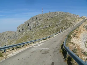
The road that leads to La Pandera, which is accessed from the road A-6.050 Jaén-Valdepeñas de Jaén-Castillo de Locubín, through a detour to the left located at the point of 24,500, is an asphalt and narrow itinerary built to access the military facilities at its top. In recent years it has become a forced quote from La Vuelta Ciclista to Spain, being considered as one of the mountain queen stages. For the first 3 km. We are accompanied by the typical landscape of the Mediterranean forest, with plenty of shrubs splashed by oak trees.
When you reach a quarry, the first important ramps appear, with slopes about 15% changing the vegetation as the altitude rises: lavender, thyme, aulagas, thorn, rosemary, cardo... The road, even in the dark, is becoming more and more difficult and offers the cycloturist the first landscape panorama. The environment is gradually becoming more arid, but the visual basin is greatly expanded and the views of Los Villares, Valdepeñas de Jaén or the capital itself, surrounded by olive fields, are impressive.


