Saltar al contenido principal

La Iruela

MUNICIPIOS
  • Castillo La Iruela
  • 00aa1637-c873-62dd-9f08-19a8dc93b82a?t=1594840447803
  • cascada-calavera-jpg
  • 142fcccc-1b78-b00f-12b9-9861653aa985?t=1594840446686
  • 984dda33-81c5-6dfc-f4c8-879496a017f7?t=1594840444901
  • cf00562e-66a8-42de-cafc-977dfa1c9576?t=1619544364548
  • 0427da0e-3bb3-5495-44e8-9e5136623cc5?t=1611000362766
  • arroyo-de-las-truchas-la-iruela-2-jpg
  • Castillo La Iruela
  • 00aa1637-c873-62dd-9f08-19a8dc93b82a?t=1594840447803
  • cascada-calavera-jpg
  • 142fcccc-1b78-b00f-12b9-9861653aa985?t=1594840446686
  • 984dda33-81c5-6dfc-f4c8-879496a017f7?t=1594840444901
  • cf00562e-66a8-42de-cafc-977dfa1c9576?t=1619544364548
  • 0427da0e-3bb3-5495-44e8-9e5136623cc5?t=1611000362766
  • arroyo-de-las-truchas-la-iruela-2-jpg

Description

La Iruela, a small and beautiful town located in the north-east of the Sierra de Cazorla region. In its western part there are the cultivated lands, the rest of the municipal term is a mountain area reforested with pine trees. It belongs to the Natural Park of the Sierras de Cazorla and Las Villas, being its main entrance door.

The municipality of La Iruela, as if it were a puzzle, is composed of numerous cores, 17 pedanias are the ones that make it up. Burunchel, El Palomar, El Burrueco, Arroyo Frio, Fontanares, La Estrella, Mortalejos, Tramaya, El Pocico, San Martín, Pasada Barrero, Los Tísanas, Arroyos de Plaza, Juntas de Muriel, Nubla, Cortijo Enroque and Cañamares.

The economic activity of the municipality rests on two basic pillars: olive cultivation and nature tourism, also highlighting forest activity.
Among its historical heritage we quote the medieval castle, the ruins of the church of Saint Domingo de Silos and the conistory house.

The Iruela has been declared Artistic Historical Set in 1985.

Useful Information

Tourist area: Serras de Cazorla, Segura and the Villas
Distance to the capital (km): 106
Altitude over sea level (m): 954
Extension (km ²): 123
Number of inhabitants: 1,899
Gentilicon: Iruelenses or Firuqueños
Postal code: 23476

Is part of

AUDIOVISUAL CONTENT

MORE INFORMATION

Culture

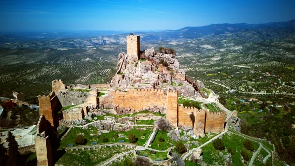
  • La Iruela Castle. The imposing castle rises on an abrupt rock and at its feet a medieval district of unquestionable architectural value is spread. It is of mothade origin and is built on pre-Berber foundations. In the eighth century, La Iruela was occupied by Muslims, who in order to cultivate the land created alqueras, then walls to defend themselves from the enemies and, already in the twelfth century, the first fortress of the three that it currently presents. The second, also the work of the Almohades, was a courtyard of weapons surrounded by a series of defensive torreons united with each other by thick wall canvas. Inside the courtyard of arms are the remains of a large aljibe. When Fernando III conquers this area, Christians reform the castle and build the tower of tribute in the highest part of the rock. An auditorium with artistic and cultural activities has been created between the castle and the rock. It was declared a Historical Monument in 1985.
  • Ruins of the church of Saint Sunday. 16th century Renaissance Church, raised inside the walled castle enclosure. The church was composed of three ships, the largest central and where the presbytery was to be found, the sides had chapels. A building attached to the church would be the old tower-door of Muslim origin that would give entrance to the interior of the Almohad fortress and that Christians reused as a bell tower. During the French invasion, La Iruela suffered attacks and fires, in one of them (1810) the building was severely damaged. Some of its noble areas are still standing today.
  • Consistory house. It is a Mudejar-style monument that in its day was posited and grain storage. It dates back to the late 15th century. He was looted and burned in the War of Independence. In the mid-19th century it was set up as the municipality of La Iruela. A remodeling made at the end of the last century gave him the present look.

Nature

The Iruela is in the skirts of the saw of Cazorla, crowning the Guadalquivir valley. It is located 932 m above sea level, which means it is the highest municipality in the entire region, and the one that has the most portion of the Natural Park of the Sierras de Cazorla, Segura and Las Villas.

If something characterizes the area is the variety in the landscapes and ecosystems, with altitudes ranging from 2,100 m in the Cabilla saw to 360 m in the vicinity of the Cerrada bridge.

The region is characterized by landscapes where the high peaks are mixed with deep ravines, soft reliefs and large valleys, forests, olive groves and high mountain pastures, orchards, humid, dry and arid areas. The altitude rises from the west to the east, but not continuously, but forming saw teeth, whose rising and incoming with progressively more pronounced, alternating river courses and summit lines.

The traditional useof these lands has been of pastures for livestock, forestry, small areas of traditional crops (olive, cereal, orchard), hunting, fishing, collection of mushrooms, wild fruits of the forest and spartum and wicker for the varied popular crafts, mainly.

These traditional uses have given way to new economic activities, mainly service companies, especially tourism, in the area of the Natural Park. Today La Iruela has a large tourist infrastructure that, together with those of the cities of Ubeda and Baeza, are the most important in the province of Jaén.

At present the olive tree has been displacing the other crops, the loins are occupied by a sea of olive trees interrupted, sometimes, by orchards, all framed in the surrounding saws. In the drier and driest areas the almonds spatter in white spring.

A space with many ecosystems in which infinity of species that make up rich and varied fauna:: from the rapacious birds, the carrionies, the cynetic species, both of major and minor hunting, the fish, amphibians, reptiles, as well as the characteristic fauna of the riverside vegetation that exists next to the stream and river.

Without a doubt, a true natural paradise to recreate. It is almost compulsory to make direct contact with one of the wonderful places that this territory hides, where in addition to observing "in situ" both vegetation and fauna, we can enjoy a fabulous panoramic view of the mountains and the jienese countryside.
Most of the land in La Iruela belongs to Mount Público Guadahornillos, with just over 6,740 hectares.

In the municipality of La Iruela, the following public equipment is highlighted:

  • Nature Hall "El Cantalar."
  • Recreative area "Tejina"
  • "Air Pass" lookout
  • Path Rio Borosa (partial)
  • Path Cold Arroyo to Cerrada de Utrero (partial)
  • Mirador "Ribera del Guadalquivir", located on the path Arroyo Frio to Cerrada de Utrero.
  • Several sections of GR-247 Southern Forests. Stage 10 "Refugio CF La Zarza - La Iruela" and derivation stage "Port of the Doves - Cold Arroyo".
  • Most of the GR-7 "Coto Rios a Vadillo Castril" and some trips of the Vadillo Castril - Quesada section.

Parties and Events

We began the festive cycle of La Iruela in January:

  • Saint Anton, January 17. It is tradition to light fires and bless animals so that Saint Anthony Abad will protect them throughout the year.
  • San Blason February 3. The traditional doughnuts are distributed and a joint raffle is made with the products that the neighbors have donated. A few days before the celebration of the party, the image is brought from its Nubla hermitage. During the procession, the saint is the reason for many offerings in thanks to the favors received.
  • Celebrations in honor of the Virgin of the Unprotected and Holy Silos Sunday. They are held in the last days of August. There are many and varied activities that are carried out: fireworks, barter championships, serrano bolus, domino tournaments, local garden and gastronomy products competition, children's theatre, pasacalles, recitals and verbenas. The Virgin is brought from her hermitage to the parish, where she will remain until the fall, when she will return to her.
  • Saint Martin and the Virgin of the Rosary. Romeria that is celebrated the first weekend of October since time immemorial. In the pedania of San Martín
  • Party in honor of the Assumption of the Virgin Mary. It is celebrated between the 13th and the 15th of August and takes place in the pedanias of Arroyo Frio and El Palmar.
  • Celebrations in honor of the Immaculate Conception and Saint Julian. From 22 to 25 August, it is held in the pedanía of Burunchel. The saint is transferred from the hermitage of Saint Julian to Burunchel, where it is processed.

Gastronomy

It shares its gastronomy with the region where it is located. In general, peas are made from land products. Among the most characteristic are the following:

  • Gachamita, which is made from olive oil, flour, water and potatoes. You can eat with chorizos, torreznos...
  • Farmed flour, which are made with hard pasta.
  • Tallarines. It consists of a stew of meat, vegetables and mushrooms in which wafers of mass are cooked that are broken.
  • Rin-Ran. It has red pepper, onion, potatoes, cod, black olives and olive oil.
  • Serrano eggs. They are usually served in saucepan with pork products, such as chorizo, scratched bacon and meat from game animals.
  • Other: In Easter the dishes made with cod and Fried artichokes.

Warehouse:

  • Lis flowers. They are made of a very liquid mass of flour and passed through the frying pan in hot iron mold.
  • Fried milk and sugar roses.

History

The first signs of human presence in the Iruela environment date from the Copper Age, with great occupation until the Bronze Age. Then there was a depopulation of the area for which the researchers have no explanation, since after time we attended a proliferation of settlements. One of them is that of Nubla, with remains of fortification and that was active from the Iberians to the medieval era, the same happening in the times of the Romans, the bridge of the Mill that crosses the Cañamares River is attributed to this period.

It has been said that the Carthaginians founded the city, that it was popular in Roman times, and that the Arabs destroyed it and then populated and rebuilt it.

During the Islamic period it must have been one of the villages that populated the region. Around the 11th century this population was walled and the top of the promontory served as a refuge.

In the time of King Fernando III and thanks to the troops of the Archbishop of Toledo, conquer the castle and the rest of the municipality. In thanks the king gives him the jurisdiction of these lands within the advance of Cazorla. By the end of the 13th century, in order to strengthen the Alfoz of Cazorla, they donate to him La Iruela as a village, but La Iruela did not want to accept this privilege given to Cazorla.

He sometimes got the privilege of a villa, but for very short spaces of time.
Francisco de los Cobos, Secretary of Charles I, got the monarch to give him the villa to the detriment of the archbishop of Toledo, who pleaded until in 1606 he recovered it again. In this short period of time, the Cobos, large mecenas on the lands of their lordship, ordered to build the church of Saint Sunday of Silos in the interior of the castle.

The archbishops of Toledo always maintained the possession of this villa until 1811, when the Cortes of Cadiz abolished the territorial jurisdiction of the archbishop of Toledo. The spiritual jurisdiction over these lands reaches 1958, when it passed to Jaén.

In this municipality

51

Accommodations

15

Restaurants

17

Services

6

Events

We recommend